NOT LISTED FOR SALE

5335 Highway 231 Ford, WA 99013

Estimated Value: $135,000 - $419,000

19.31 Acres
$13,717 Price per Acre
841,144 Sq Ft Lot

Sale Details

Date Sold: October 24, 2025

Last sale price $135,000

Est. 96% increase in value since last sale

Current estimated payment $1,573 / mo

3 Days on Market

Highlights

  • 19.31 Acre Lot
  • No HOA
  • Landscaped with Trees
  • Territorial View
  • Pasture
  • Spring water is a source of water for the property

About This Lot

As of October 2025

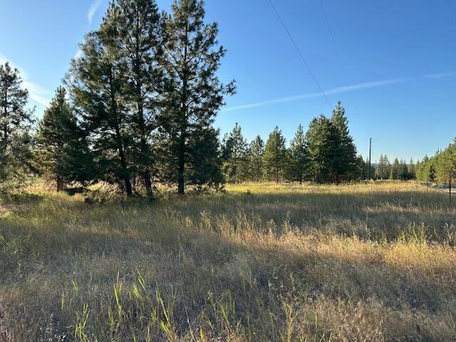
Beautiful property features 19 acres of level, usable land with easy access of state hwy 231. High producing well for plenty of water for your garden, household or animals. Power is at the road. Bring your critters and house plans and create the country living paradise you are dreaming of! Great location, 10 miles from Springdale, 20 miles from Reardan.

Last Agent to Sell the Property

Day Star Realty Team

KELLER WILLIAMS REALTY COLVILLE Listed on: 08/22/2025

KELLER WILLIAMS REALTY COLVILLE

Last Buyer's Agent

Kimberly Dailey

JOHN L. SCOTT, INC. License #133367

JOHN L. SCOTT, INC.

Property Details

Property Type

  • Land

Est. Annual Taxes

  • $437

Lot Details

  • 19.31 Acre Lot
  • Rural Setting
  • Partially Fenced Property
  • Level Lot
  • Landscaped with Trees
  • Property is zoned County

Utilities

  • Electricity To Lot Line
  • Spring water is a source of water for the property
  • Drilled Well
  • Sewer Not Available

Additional Features

  • Territorial Views
  • Pasture
  • Mobile Home Allowed

Community Details

  • No Home Owners Association

Listing and Financial Details

  • Assessor Parcel Number 2441206

Property Details

Property Type

Land

Est. Annual Taxes

$437

Lot Details

19.31 Acres

Listing Details

  • Directions: Hwy 231 in Ford Washington
  • Prop. Type: Land
  • Property Sub-Type: Acreage
  • LotFeatures: Pasture
  • Lot Size Acres: 19.31
  • Co List Office Phone: 509-684-1414
  • MLS Status: Closed
  • Accessibility Features: Public Road, Paved
  • Master Plan Zoning: County
  • Property Information Waterfront: None
  • Property Information Lot Dimensions: irregular
  • Property Information # of Acres: 19.31
  • Location Tax Legal:Taxes2: $437
  • Topography:Level: Yes
  • Property Information Crops: No
  • Property Information CCR'S: Unknown
  • Property Information Setting: Rural
  • Property Information Borders Govt: No
  • Property Information Mobile Approved: Yes
  • Property Information Developed Water: Yes
  • Sewage None4: Yes
  • View Territorial: Yes
  • Highlights Pasture2: Yes
  • Highlights Moderate Trees: Yes
  • Utilities PowerProperty Line: Yes
  • Water System Drilled Well: Yes
  • Improvements Partial Fencing: Yes
  • Special Features: None
  • Property Sub Type: LotsLands

Exterior Features

  • Topography: Level
  • View: Territorial

Utilities

  • Water Source: Drilled Well

Condo/Co-op/Association

  • Association Fee Frequency: None
  • Association: No

Lot Info

  • Current Use: Residential
  • Parcel #: 2441206
  • Lot Dimensions: irregular
  • Lot Size Sq Ft: 841143.6
  • ResoLotSizeUnits: Acres
  • Zoning Description: Residential

Ownership History

Date Name Owned For Owner Type

Purchase Details

Closed on
Oct 10, 2017
Sold by
Peterson Burdette D
Bought by
Buter Joseph G and Buter Marcella V
Current Estimated Value
$264,882

Home Financials for this Owner

Home Financials are based on the most recent Mortgage that was taken out on this home.
Original Mortgage
$196,377
Outstanding Balance
$162,817
Interest Rate
3.99%
Mortgage Type
FHA
Estimated Equity
$102,065

Purchase Details

Closed on
Mar 10, 2014
Sold by
Pritchard Marion A and Pritchard Gwen E
Bought by
Peterson Burdette D
Source: Public Records
Create a Home Valuation Report for This Property
The Home Valuation Report is an in-depth analysis detailing your home's value as well as a comparison with similar homes in the area

Purchase History

Date Buyer Sale Price Title Company
Buter Joseph G $200,000 Stevens County Title Co
Peterson Burdette D $143,000 Stevens County Title Company
Source: Public Records

Mortgage History

Date Status Borrower Loan Amount
Open Buter Joseph G $196,377
Source: Public Records

Property History

Date Event Price List to Sale Price per Sq Ft
10/24/2025 10/24/25 Sold $135,000 0.0% --
08/25/2025 08/25/25 Pending -- -- --
08/22/2025 08/22/25 For Sale $135,000 -- --
Source: Northeast Washington Association of REALTORS®

Tax History

Year Tax Paid Tax Assessment Tax Assessment Total Assessment is a certain percentage of the fair market value that is determined by local assessors to be the total taxable value of land and additions on the property. Land Improvement
2025 $2,018 $276,441 $56,000 $220,441
2024 $2,018 $263,242 $56,000 $207,242
2023 $1,975 $263,390 $56,000 $207,390
2022 $1,582 $191,058 $56,000 $135,058
2021 $1,628 $177,046 $56,000 $121,046
2020 $1,409 $177,046 $56,000 $121,046
2019 $1,549 $150,370 $50,000 $100,370
2018 $1,210 $142,329 $50,000 $92,329
2017 $1,068 $107,460 $30,000 $77,460
2016 $1,019 $107,460 $30,000 $77,460
2015 $1,024 $101,910 $30,000 $71,910
2013 -- $101,910 $30,000 $71,910
Source: Public Records

Agents Affiliated with this Home

  • Section Image
  • Section Image
See All Agents

Map

Source: Northeast Washington Association of REALTORS®

MLS Number: 45060

APN: 2441210

Your Personal Tour Guide

Ask me questions while you tour the home.