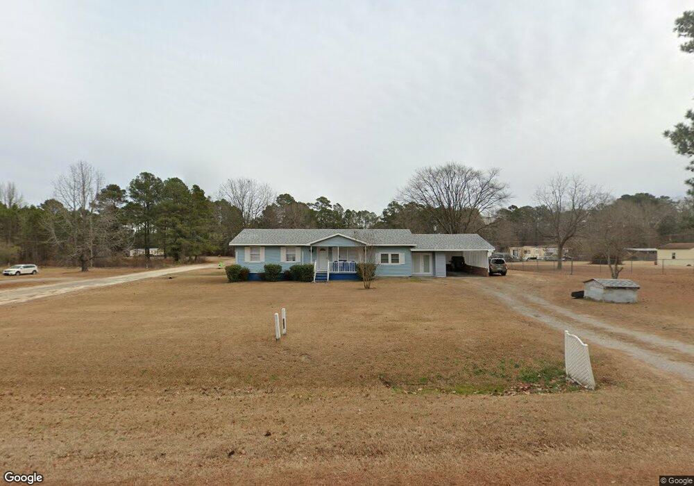
538 Farley Cir Roanoke Rapids, NC 27870
Estimated Value: $111,000 - $180,000
3
Beds
2
Baths
1,248
Sq Ft
$111/Sq Ft
Est. Value
About This Home
This home is located at 538 Farley Cir, Roanoke Rapids, NC 27870 and is currently estimated at $138,032, approximately $110 per square foot. 538 Farley Cir is a home located in Halifax County with nearby schools including Aurelian Springs Elementary School, William R. Davie Middle School, and Northwest Halifax High School.
Ownership History
Date
Name
Owned For
Owner Type
Purchase Details
Closed on
May 5, 2021
Sold by
Jones Tuwana Pierce and Jones Danny Barrett
Bought by
Jones Khiyah Cellane
Current Estimated Value
Home Financials for this Owner
Home Financials are based on the most recent Mortgage that was taken out on this home.
Original Mortgage
$105,000
Outstanding Balance
$87,418
Interest Rate
3.1%
Mortgage Type
New Conventional
Estimated Equity
$50,614
Create a Home Valuation Report for This Property
The Home Valuation Report is an in-depth analysis detailing your home's value as well as a comparison with similar homes in the area
Purchase History
| Date | Buyer | Sale Price | Title Company |
|---|---|---|---|
| Jones Khiyah Cellane | $105,000 | None Available |
Source: Public Records
Mortgage History
| Date | Status | Borrower | Loan Amount |
|---|---|---|---|
| Open | Jones Khiyah Cellane | $105,000 |
Source: Public Records
Tax History
| Year | Tax Paid | Tax Assessment Tax Assessment Total Assessment is a certain percentage of the fair market value that is determined by local assessors to be the total taxable value of land and additions on the property. | Land | Improvement |
|---|---|---|---|---|
| 2025 | $11 | $94,600 | $6,100 | $88,500 |
| 2024 | $11 | $94,600 | $6,100 | $88,500 |
| 2023 | $975 | $79,000 | $6,100 | $72,900 |
| 2022 | $978 | $79,000 | $6,100 | $72,900 |
| 2021 | $948 | $79,000 | $6,100 | $72,900 |
| 2020 | $956 | $79,000 | $6,100 | $72,900 |
| 2019 | $900 | $72,100 | $6,000 | $66,100 |
| 2018 | $899 | $72,100 | $6,000 | $66,100 |
| 2017 | $887 | $72,100 | $6,000 | $66,100 |
| 2016 | $828 | $72,100 | $6,000 | $66,100 |
| 2015 | $775 | $72,100 | $6,000 | $66,100 |
| 2014 | $789 | $78,800 | $6,480 | $72,320 |
Source: Public Records
Map
Nearby Homes
- 163 Deer Run Rd
- 38 US Highway 158
- 62 Hickory Cir
- 63 Hickory Cir
- 40 Green Ash Ct
- 38 Green Ash Ct
- 39 Green Ash Ct
- 37 Bald Eagle Dr
- 21 Bald Eagle Dr
- 25 Bald Eagle Dr
- 29 Bald Eagle Dr
- 31 Bald Eagle Dr
- 33 Bald Eagle Dr
- 35 Bald Eagle Dr
- 24 Bald Eagle Dr
- 26 Bald Eagle Dr
- 28 Bald Eagle Dr
- 32 Bald Eagle Dr
- 34 Bald Eagle Dr
- 36 Bald Eagle Dr
- 215 Cosmos Ln
- 506 Farley Cir
- 568 Farley Cir
- 30 Star Dr
- 590 Farley Cir
- 549 Farley Cir
- Lot# 17 River's Edge
- 745 River's Edge Pkwy
- 741 River's Edge
- 0 Industrial Unit 60043894
- 581 Farley Cir
- 499 Farley Cir
- 597 Farley Cir
- 56 Star Dr
- 628 Farley Cir
- 483 Farley Cir
- 2403 Sam Powell Dairy Rd
- 623 Farley Cir
- 453 Farley Cir
- 2395 Sam Powell Dairy Rd
Your Personal Tour Guide
Ask me questions while you tour the home.