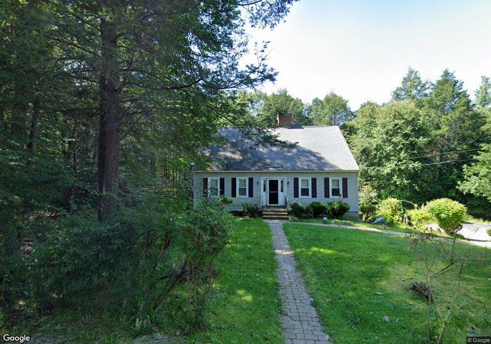
54 Willard Rd Westminster, MA 01473
Estimated Value: $555,504 - $688,000
3
Beds
3
Baths
2,100
Sq Ft
$299/Sq Ft
Est. Value
About This Home
This home is located at 54 Willard Rd, Westminster, MA 01473 and is currently estimated at $628,876, approximately $299 per square foot. 54 Willard Rd is a home located in Worcester County with nearby schools including Oakmont Regional High School.
Ownership History
Date
Name
Owned For
Owner Type
Purchase Details
Closed on
Nov 2, 2024
Sold by
Lathrop Alan R
Bought by
Lathrop Daniel R
Current Estimated Value
Purchase Details
Closed on
Jul 31, 2019
Sold by
Lathrop Daniel R and Lathrop Alicia
Bought by
Lathrop Daniel R and Lathrop Alan R
Purchase Details
Closed on
Jan 15, 2010
Sold by
Holmes Samuel B and White Rachael A
Bought by
Lathrop Daniel R and Lathrop Alicia
Home Financials for this Owner
Home Financials are based on the most recent Mortgage that was taken out on this home.
Original Mortgage
$267,755
Interest Rate
5.25%
Mortgage Type
FHA
Purchase Details
Closed on
Jun 15, 2007
Sold by
Fisher Howard W and Fisher Rita T
Bought by
White Rachael A and Holmes Samuel B
Home Financials for this Owner
Home Financials are based on the most recent Mortgage that was taken out on this home.
Original Mortgage
$294,300
Interest Rate
6.19%
Mortgage Type
Purchase Money Mortgage
Create a Home Valuation Report for This Property
The Home Valuation Report is an in-depth analysis detailing your home's value as well as a comparison with similar homes in the area
Home Values in the Area
Average Home Value in this Area
Purchase History
| Date | Buyer | Sale Price | Title Company |
|---|---|---|---|
| Lathrop Daniel R | -- | None Available | |
| Lathrop Daniel R | -- | None Available | |
| Lathrop Daniel R | -- | -- | |
| Lathrop Daniel R | $277,000 | -- | |
| White Rachael A | $327,000 | -- | |
| Lathrop Daniel R | $277,000 | -- | |
| White Rachael A | $327,000 | -- |
Source: Public Records
Mortgage History
| Date | Status | Borrower | Loan Amount |
|---|---|---|---|
| Previous Owner | Lathrop Daniel R | $267,755 | |
| Previous Owner | White Rachael A | $294,300 | |
| Previous Owner | White Rachael A | $50,000 | |
| Previous Owner | White Rachael A | $56,800 |
Source: Public Records
Tax History
| Year | Tax Paid | Tax Assessment Tax Assessment Total Assessment is a certain percentage of the fair market value that is determined by local assessors to be the total taxable value of land and additions on the property. | Land | Improvement |
|---|---|---|---|---|
| 2025 | $5,494 | $446,700 | $123,400 | $323,300 |
| 2024 | $5,256 | $428,700 | $123,400 | $305,300 |
| 2023 | $5,280 | $404,300 | $115,400 | $288,900 |
| 2022 | $5,318 | $336,600 | $100,300 | $236,300 |
| 2021 | $5,211 | $310,900 | $87,300 | $223,600 |
| 2020 | $5,093 | $290,200 | $79,300 | $210,900 |
| 2019 | $5,048 | $276,600 | $65,700 | $210,900 |
| 2018 | $4,741 | $255,600 | $65,700 | $189,900 |
| 2017 | $4,573 | $251,400 | $65,700 | $185,700 |
| 2016 | $4,518 | $240,600 | $54,700 | $185,900 |
| 2015 | $4,870 | $257,000 | $54,700 | $202,300 |
| 2014 | $4,878 | $257,000 | $54,700 | $202,300 |
Source: Public Records
Map
Nearby Homes
- 169 Narrows Rd
- 20 Battles Rd
- 5 Notown Rd
- Lot 0 Narrows Rd
- 3 Linda Dr
- 2 Roberts Way
- 76 Saw Mill Pond Rd
- 2 Taymax Rd
- 23 Hager Park Rd
- 0 Worcester Rd Unit 73326124
- 0 Syd Smith Rd Unit 73395578
- 0 Syd Smith Rd (Rear)
- 0 Syd Smith Rd Map 71 Lot 4-2
- 0
- 97 Worcester Rd
- 17 Leominster St
- 2 Seaver St
- 1199 Franklin Rd
- 147 Constitution Dr Unit 147
- 72 Green Briar Rd
Your Personal Tour Guide
Ask me questions while you tour the home.