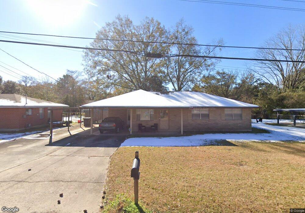
5420 Devore Dr Baton Rouge, LA 70811
Scotlandville NeighborhoodEstimated Value: $150,750 - $174,000
About This Home
This home is located at 5420 Devore Dr, Baton Rouge, LA 70811 and is currently estimated at $162,438, approximately $117 per square foot. 5420 Devore Dr is a home located in East Baton Rouge Parish with nearby schools including Brownfields Elementary School, Scotlandville Magnet High School, and Impact Charter School.
Ownership History
We collect this data history from publicly available records. To have your information removed, we recommend requesting removal directly through your county’s website.
Purchase Details
Home Financials for this Owner
Home Financials are based on the most recent Mortgage that was taken out on this home.Purchase Details
Home Values in the Area
Average Home Value in this Area
Purchase History
We collect this data history from publicly available records. To have your information removed, we recommend requesting removal directly through your county’s website.
| Date | Buyer | Sale Price | Title Company |
|---|---|---|---|
| $108,000 | -- | ||
| -- | -- |
Mortgage History
We collect this data history from publicly available records. To have your information removed, we recommend requesting removal directly through your county’s website.
| Date | Status | Borrower | Loan Amount |
|---|---|---|---|
| Open | $105,624 |
Tax History
We collect this data history from publicly available records. To have your information removed, we recommend requesting removal directly through your county’s website.
| Year | Tax Paid | Tax Assessment Tax Assessment Total Assessment is a certain percentage of the fair market value that is determined by local assessors to be the total taxable value of land and additions on the property. | Land | Improvement |
|---|---|---|---|---|
| 2025 | $821 | $13,675 | $739 | $12,936 |
| 2024 | $821 | $13,675 | $739 | $12,936 |
| 2023 | $825 | $12,210 | $660 | $11,550 |
| 2022 | $1,656 | $12,210 | $660 | $11,550 |
| 2021 | $1,629 | $12,210 | $660 | $11,550 |
| 2020 | $1,647 | $12,210 | $660 | $11,550 |
| 2019 | $1,553 | $11,100 | $600 | $10,500 |
| 2018 | $1,536 | $11,100 | $600 | $10,500 |
| 2017 | $1,536 | $11,100 | $600 | $10,500 |
| 2016 | $509 | $11,100 | $600 | $10,500 |
| 2015 | $442 | $10,800 | $600 | $10,200 |
| 2014 | $441 | $10,800 | $600 | $10,200 |
| 2013 | -- | $10,800 | $600 | $10,200 |
Map
- 11747 Troy St
- 0000 Plank Rd
- 5765 Kleinpeter Rd
- 12265 Plank Rd
- 11940 Newsom Dr
- 5656 Guice Dr
- 11225 Plank Rd
- 000000 Clark St
- 4534 Clark St
- 6313 Kleinpeter Rd
- 6345 Kleinpeter Rd
- 6525 Kleinpeter Rd
- 13405 Lillywood Ct
- 5404 Gallantry Ct
- 5362 Gallantry Ct
- 5356 Gallantry Ct
- 13302 Lillywood Ct
- 5410 Gallantry Ct
- 13405 Lilywood Ct
- 13309 Lilywood Ct
- 5450 Devore Dr
- 5380 Devore Dr
- 5425 Devore Dr
- 5445 Devore Dr
- 5415 Truman St
- 5453 Truman St
- 5375 Devore Dr
- 5476 Devore Dr
- 5364 Devore Dr
- 5455 Devore Dr
- 5465 Truman St
- 5363 Devore Dr
- 5351 Truman St
- 5410 Brownfields Dr
- 5400 Brownfields Dr
- 5418 Brownfields Dr
- 5484 Devore Dr
- 5344 Devore Dr
- 5477 Truman St
- 5465 Devore Dr
Ask me questions while you tour the home.