Estimated Value: $98,543 - $197,000
Studio
--
Bath
--
Sq Ft
20,038
Sq Ft Lot
About This Home
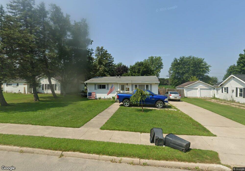
This home is located at 5426 Sandusky Rd, Peck, MI 48466 and is currently estimated at $153,636. 5426 Sandusky Rd is a home with nearby schools including Peck Community Elementary School and Peck Junior/Senior High School.
Ownership History
Date
Name
Owned For
Owner Type
Purchase Details
Closed on
Jul 24, 2020
Sold by
Erick Ford
Bought by
Frizzle Scott and Frizzle April
Current Estimated Value
Home Financials for this Owner
Home Financials are based on the most recent Mortgage that was taken out on this home.
Original Mortgage
$91,919
Outstanding Balance
$81,355
Interest Rate
3%
Mortgage Type
New Conventional
Estimated Equity
$72,281
Purchase Details
Closed on
Jul 2, 2015
Sold by
Francis Agnes
Bought by
Ford Erick
Purchase Details
Closed on
Mar 15, 2002
Sold by
Quinlan William
Bought by
Francis Agnes
Purchase Details
Closed on
Aug 22, 1995
Sold by
Welsh Thomas A
Bought by
Quinlan William and Quinlan Leona B
Create a Home Valuation Report for This Property
The Home Valuation Report is an in-depth analysis detailing your home's value as well as a comparison with similar homes in the area
Purchase History
| Date | Buyer | Sale Price | Title Company |
|---|---|---|---|
| Frizzle Scott | -- | -- | |
| Ford Erick | $47,000 | -- | |
| Francis Agnes | $70,000 | -- | |
| Quinlan William | $55,000 | -- |
Source: Public Records
Mortgage History
| Date | Status | Borrower | Loan Amount |
|---|---|---|---|
| Open | Frizzle Scott | $91,919 |
Source: Public Records
Tax History
| Year | Tax Paid | Tax Assessment Tax Assessment Total Assessment is a certain percentage of the fair market value that is determined by local assessors to be the total taxable value of land and additions on the property. | Land | Improvement |
|---|---|---|---|---|
| 2025 | $631 | $43,950 | $0 | $0 |
| 2024 | $360 | $37,400 | $0 | $0 |
| 2023 | $358 | $29,700 | $0 | $0 |
| 2022 | $341 | $25,750 | $0 | $0 |
| 2021 | $511 | $21,506 | $0 | $0 |
| 2020 | $985 | $20,926 | $0 | $0 |
| 2019 | $231 | $17,488 | $0 | $0 |
| 2018 | $255 | $19,369 | $0 | $0 |
| 2017 | $253 | $19,205 | $0 | $0 |
| 2016 | $294 | $19,767 | $0 | $0 |
| 2015 | -- | $20,427 | $0 | $0 |
| 2014 | -- | $18,858 | $0 | $0 |
Source: Public Records
Map
Nearby Homes
- 95 W Lapeer St
- 8 Lila
- 5645 Mill St
- 5475 Roho
- 0001 Duquette Rd
- 5375 Shawn St
- 2240 Mark St
- 2259 Bart St
- 8060 Brockway Rd
- 2880 S Sandusky Rd
- 0 E Wellman Line Rd
- 3155 Peck Rd
- 3211 Willis Rd
- 00000 Galbraith Line Rd
- VL Galbraith Line Rd
- 0 Mortimer Line Unit 25023305
- 3544 Burnsline Rd
- 8706 Cork Rd
- 0 La Salle St
- 00 La Salle St
- 5416 Sandusky Rd
- 30 W Rebecca St
- 5436 Sandusky Rd
- 5406 Sandusky Rd
- 84 W Rebecca St
- 5380 Sandusky Rd
- 5425 Sandusky Rd
- 5409 Sandusky Rd
- 5417 Sandusky Rd
- 5470 Sandusky Rd
- 5389 Sandusky Rd
- 5366 Sandusky Rd
- 5457 Sandusky Rd
- 5470 Bartlett St
- 30 E Pine St
- 5362 Sandusky Rd
- 19 E Rebecca St
- 5469 Sandusky Rd
- 5367 Sandusky Rd
- 25 E Pine St
Your Personal Tour Guide
Ask me questions while you tour the home.