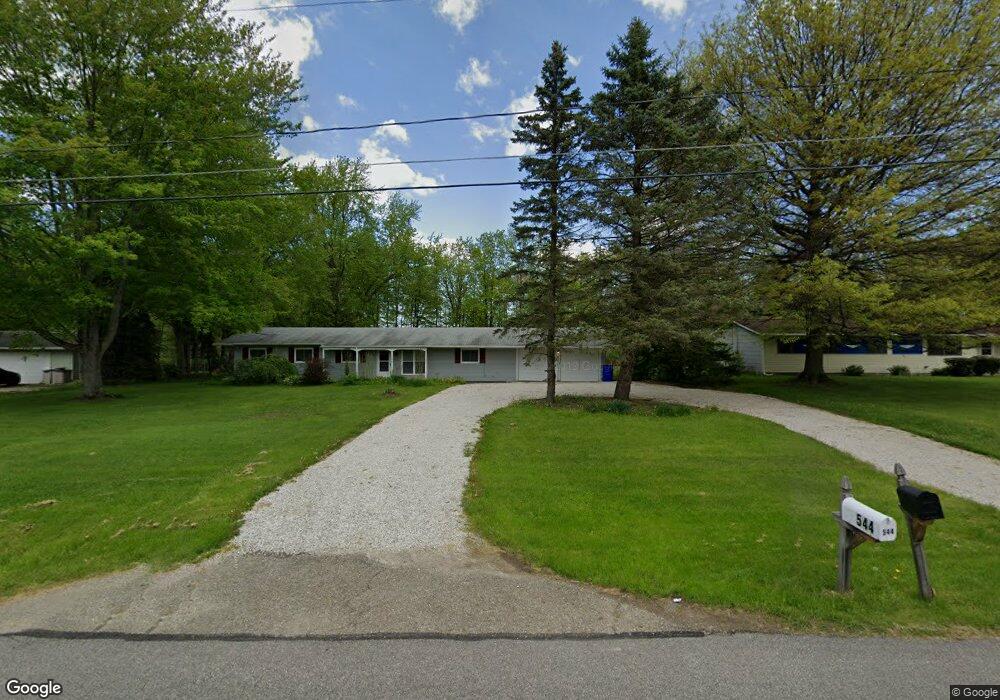
544 Robinhood Dr Aurora, OH 44202
Estimated Value: $286,000 - $316,000
About This Home
This home is located at 544 Robinhood Dr, Aurora, OH 44202 and is currently estimated at $298,320, approximately $167 per square foot. 544 Robinhood Dr is a home located in Portage County with nearby schools including Miller Elementary School, Craddock/Miller Elementary School, and Leighton Elementary School.
Ownership History
We collect this data history from publicly available records. To have your information removed, we recommend requesting removal directly through your county’s website.
Purchase Details
Purchase Details
Home Financials for this Owner
Home Financials are based on the most recent Mortgage that was taken out on this home.Purchase Details
Home Financials for this Owner
Home Financials are based on the most recent Mortgage that was taken out on this home.Purchase Details
Home Financials for this Owner
Home Financials are based on the most recent Mortgage that was taken out on this home.Home Values in the Area
Average Home Value in this Area
Purchase History
We collect this data history from publicly available records. To have your information removed, we recommend requesting removal directly through your county’s website.
| Date | Buyer | Sale Price | Title Company |
|---|---|---|---|
| $73,334 | None Available | ||
| $56,000 | None Available | ||
| $148,000 | Minnesota | ||
| $90,000 | -- |
Mortgage History
We collect this data history from publicly available records. To have your information removed, we recommend requesting removal directly through your county’s website.
| Date | Status | Borrower | Loan Amount |
|---|---|---|---|
| Previous Owner | $44,800 | ||
| Previous Owner | $148,000 | ||
| Previous Owner | $89,622 |
Tax History
We collect this data history from publicly available records. To have your information removed, we recommend requesting removal directly through your county’s website.
| Year | Tax Paid | Tax Assessment Tax Assessment Total Assessment is a certain percentage of the fair market value that is determined by local assessors to be the total taxable value of land and additions on the property. | Land | Improvement |
|---|---|---|---|---|
| 2025 | $3,794 | $81,660 | $15,160 | $66,500 |
| 2024 | $3,729 | $81,660 | $15,160 | $66,500 |
| 2023 | $3,624 | $64,580 | $15,160 | $49,420 |
| 2022 | $3,299 | $64,580 | $15,160 | $49,420 |
| 2021 | $3,340 | $64,580 | $15,160 | $49,420 |
| 2020 | $2,858 | $51,490 | $15,160 | $36,330 |
| 2019 | $2,865 | $51,490 | $15,160 | $36,330 |
| 2018 | $2,511 | $42,010 | $15,160 | $26,850 |
| 2017 | $2,511 | $42,010 | $15,160 | $26,850 |
| 2016 | $2,248 | $42,010 | $15,160 | $26,850 |
| 2015 | $2,312 | $42,010 | $15,160 | $26,850 |
| 2014 | $2,388 | $42,010 | $15,160 | $26,850 |
| 2013 | $2,344 | $42,010 | $15,160 | $26,850 |
Map
- 635 Sherwood Dr
- 684 Sherwood Dr
- 435 Dunwoody Dr
- 520 Bristol Dr
- 390 Blair Cir
- 545 Bristol Dr
- 959 Grand View Ln
- 436 Cochran Rd
- 460 Club Dr
- 752 Club Dr W
- 762 Club Dr W
- 900 Rock Creek Dr
- 560 Club Dr
- 715 Lake Trail
- S/L 2 Trentstone Cir
- 887 Colony Dr
- 705 Lake Trail
- 191 Brighton Dr
- 636 Cherry Park Oval
- S/L 17 Trentstone Cir
- 554 Robinhood Dr
- 536 Robinhood Dr
- 524 Robinhood Dr
- 566 Robinhood Dr
- 543 Robinhood Dr
- 553 Robinhood Dr
- 535 Robinhood Dr
- 516 Robinhood Dr
- 576 Robinhood Dr
- 565 Robinhood Dr
- 523 Robinhood Dr
- 575 Robinhood Dr
- 515 Robinhood Dr
- 500 Robinhood Dr
- 584 Robinhood Dr
- 544 Sherwood Dr
- 499 Robinhood Dr
- 583 Robinhood Dr
- 554 Sherwood Dr
- 536 Sherwood Dr
Ask me questions while you tour the home.