Estimated Value: $308,000 - $352,000
3
Beds
1
Bath
948
Sq Ft
$349/Sq Ft
Est. Value
About This Home
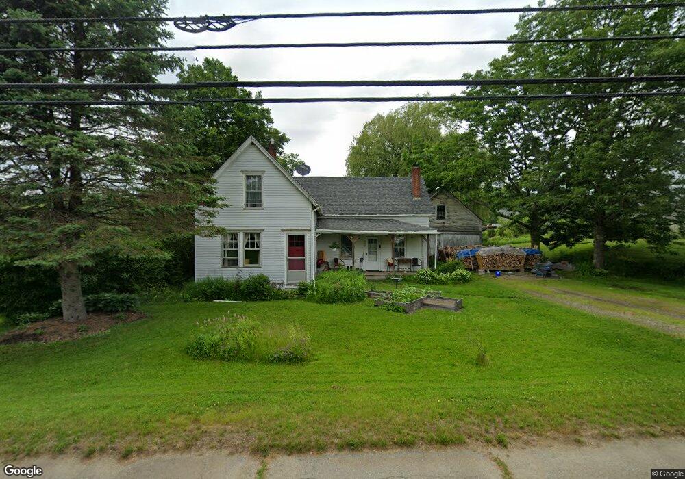
This home is located at 548 Common Rd, Union, ME 04862 and is currently estimated at $330,756, approximately $348 per square foot. 548 Common Rd is a home located in Knox County with nearby schools including Medomak Valley High School.
Ownership History
Date
Name
Owned For
Owner Type
Purchase Details
Closed on
Nov 23, 2005
Sold by
Knight Abraham A
Bought by
Vonkamecke Julie P and Von Kamecke P
Current Estimated Value
Home Financials for this Owner
Home Financials are based on the most recent Mortgage that was taken out on this home.
Original Mortgage
$104,000
Outstanding Balance
$28,681
Interest Rate
6.06%
Mortgage Type
Purchase Money Mortgage
Estimated Equity
$302,075
Create a Home Valuation Report for This Property
The Home Valuation Report is an in-depth analysis detailing your home's value as well as a comparison with similar homes in the area
Home Values in the Area
Average Home Value in this Area
Purchase History
| Date | Buyer | Sale Price | Title Company |
|---|---|---|---|
| Vonkamecke Julie P | -- | -- |
Source: Public Records
Mortgage History
| Date | Status | Borrower | Loan Amount |
|---|---|---|---|
| Open | Vonkamecke Julie P | $104,000 | |
| Closed | Vonkamecke Julie P | $13,000 |
Source: Public Records
Tax History
| Year | Tax Paid | Tax Assessment Tax Assessment Total Assessment is a certain percentage of the fair market value that is determined by local assessors to be the total taxable value of land and additions on the property. | Land | Improvement |
|---|---|---|---|---|
| 2025 | $3,893 | $292,700 | $166,700 | $126,000 |
| 2024 | $3,989 | $231,900 | $81,200 | $150,700 |
| 2023 | $3,594 | $231,900 | $81,200 | $150,700 |
| 2022 | $3,432 | $231,900 | $81,200 | $150,700 |
| 2021 | $2,677 | $147,900 | $54,100 | $93,800 |
| 2020 | $2,662 | $147,900 | $54,100 | $93,800 |
| 2019 | $2,707 | $147,900 | $54,100 | $93,800 |
| 2018 | $2,277 | $147,900 | $54,100 | $93,800 |
| 2017 | $2,337 | $147,900 | $54,100 | $93,800 |
| 2016 | $2,229 | $131,900 | $54,100 | $77,800 |
| 2015 | $2,137 | $131,900 | $54,100 | $77,800 |
| 2014 | $2,097 | $131,900 | $54,100 | $77,800 |
Source: Public Records
Map
Nearby Homes
- 291 Mic Mac Ln
- Lot 9 & 15 S Union Rd
- 261 S Union Rd
- 425 Sennebec Rd
- 122 Oak Point Ln
- 84 Dewmar Ln
- 00 W Appleton Rd
- 2529 Heald Hwy
- 38 Jasmine Ln
- 23 Bonnie Ln
- 84 Annis Ln
- Lot #1 Millay Ln
- 21 Shepard Hill Rd
- 1941 Eastern Rd
- 32 Pound Hill Rd
- 00 Clarry Hill Rd
- 3 Clarry Hill Ln
- 163 Main St
- Lot #26 Sennebec Rd
- 110 Jackson Rd
- 572 Common Rd
- 1422 Heald Hwy
- 1438 Heald Hwy
- 9 S Union Rd
- 523 Common Rd
- 0 Barrett Hill Unit 859943
- 0 Barrett Hill Unit 780502
- 0 Barrett Hill Unit 659101
- 0 Barrett Hill Unit 514001
- 0 Barrett Hill Unit 386231
- 0 Barrett Hill Unit 364073
- 0 Barrett Hill Unit 764869
- 0 Barrett Hill Unit 601931
- 0 Barrett Hill Unit 507729
- 0 Barrett Hill Unit 549221
- 0 Barrett Hill Unit 306897
- 0 Barrett Hill Unit 672903
- 0 Barrett Hill Unit 910941
- 0 Barrett Hill Unit 954528
- Lot 2 Barret Hill Rd
Your Personal Tour Guide
Ask me questions while you tour the home.