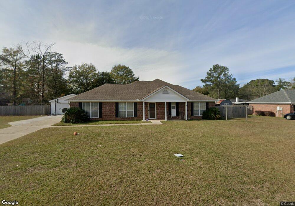
5489 Maple Ct Satsuma, AL 36572
Satsuma AreaEstimated Value: $201,000 - $298,000
About This Home
This home is located at 5489 Maple Ct, Satsuma, AL 36572 and is currently estimated at $251,172, approximately $147 per square foot. 5489 Maple Ct is a home located in Mobile County with nearby schools including Robert E. Lee Elementary School, Satsuma High School, and Satsuma Christian School.
Ownership History
We collect this data history from publicly available records. To have your information removed, we recommend requesting removal directly through your county’s website.
Purchase Details
Home Financials for this Owner
Home Financials are based on the most recent Mortgage that was taken out on this home.Purchase Details
Purchase Details
Home Financials for this Owner
Home Financials are based on the most recent Mortgage that was taken out on this home.Home Values in the Area
Average Home Value in this Area
Purchase History
We collect this data history from publicly available records. To have your information removed, we recommend requesting removal directly through your county’s website.
| Date | Buyer | Sale Price | Title Company |
|---|---|---|---|
| $239,500 | None Listed On Document | ||
| $140,000 | None Available | ||
| $93,000 | -- |
Mortgage History
We collect this data history from publicly available records. To have your information removed, we recommend requesting removal directly through your county’s website.
| Date | Status | Borrower | Loan Amount |
|---|---|---|---|
| Open | $118,030 | ||
| Closed | $100,000 | ||
| Previous Owner | $5,901 | ||
| Previous Owner | $124,620 | ||
| Previous Owner | $30,000 | ||
| Previous Owner | $92,988 | ||
| Previous Owner | $92,270 | ||
| Previous Owner | $74,400 |
Tax History
We collect this data history from publicly available records. To have your information removed, we recommend requesting removal directly through your county’s website.
| Year | Tax Paid | Tax Assessment Tax Assessment Total Assessment is a certain percentage of the fair market value that is determined by local assessors to be the total taxable value of land and additions on the property. | Land | Improvement |
|---|---|---|---|---|
| 2025 | $935 | $16,400 | $2,400 | $14,000 |
| 2024 | $935 | $16,580 | $2,400 | $14,180 |
| 2023 | $946 | $15,620 | $2,000 | $13,620 |
| 2022 | $832 | $14,740 | $2,000 | $12,740 |
| 2021 | $737 | $13,180 | $1,600 | $11,580 |
| 2020 | $744 | $13,300 | $1,600 | $11,700 |
| 2019 | $792 | $14,080 | $0 | $0 |
| 2018 | $800 | $14,220 | $0 | $0 |
| 2017 | $731 | $13,080 | $0 | $0 |
| 2016 | $752 | $13,420 | $0 | $0 |
| 2013 | $603 | $10,880 | $0 | $0 |
Map
- 150 Orange Ave E
- 204 Bayou Ave E
- 57 Willie Crook Ave
- 5303 U S 43
- 0 Willie Crook Ave
- 19 Bradford Ave
- 5523 Darring St
- 5522 6th St
- 32 Oak Ave
- 0 Raegan Ln Unit 386633
- 0 Raegan Ln Unit 386635
- 0 Travelers Ct Unit 315632
- 49 Plateau Ave W
- 311 Magnolia Ave Unit 54
- 161 Magnolia Ave
- 0 Kalifield Blvd Unit 7706300
- 5499 Timberland Dr
- 5665 Orchard St
- 0 Travellers Ct Unit 34
- 5719 Warrior Dr
Ask me questions while you tour the home.