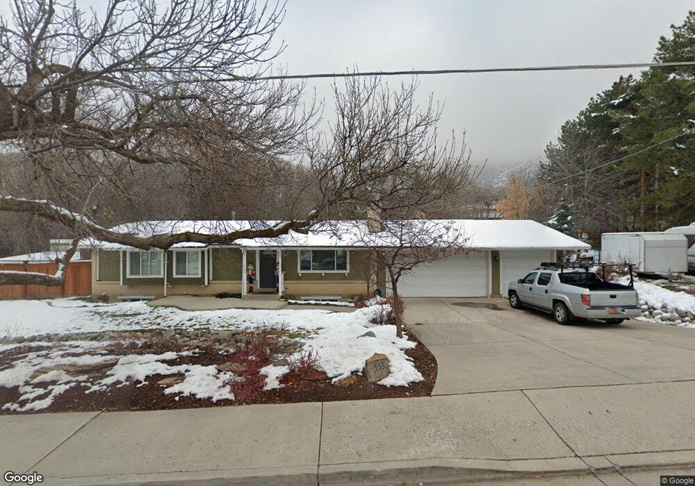
553 S High Bench Rd Alpine, UT 84004
Estimated Value: $672,000 - $830,316
5
Beds
3
Baths
2,289
Sq Ft
$321/Sq Ft
Est. Value
About This Home
This home is located at 553 S High Bench Rd, Alpine, UT 84004 and is currently estimated at $735,329, approximately $321 per square foot. 553 S High Bench Rd is a home located in Utah County with nearby schools including Alpine School, Timberline Middle School, and Lone Peak High School.
Ownership History
Date
Name
Owned For
Owner Type
Purchase Details
Closed on
Nov 29, 2016
Sold by
Hurd William F
Bought by
Hurd William F and Hurd Danee M
Current Estimated Value
Home Financials for this Owner
Home Financials are based on the most recent Mortgage that was taken out on this home.
Original Mortgage
$532,500
Outstanding Balance
$520,916
Interest Rate
3.54%
Mortgage Type
Reverse Mortgage Home Equity Conversion Mortgage
Estimated Equity
$214,413
Purchase Details
Closed on
Nov 9, 2016
Sold by
Thorn Kevin and Thorn Amanda
Bought by
Hurd William F
Home Financials for this Owner
Home Financials are based on the most recent Mortgage that was taken out on this home.
Original Mortgage
$532,500
Outstanding Balance
$520,916
Interest Rate
3.54%
Mortgage Type
Reverse Mortgage Home Equity Conversion Mortgage
Estimated Equity
$214,413
Purchase Details
Closed on
May 30, 2008
Sold by
Coverston Sam Jason and Coverston Gaylee
Bought by
Thorn Kevin and Thorn Amanda
Home Financials for this Owner
Home Financials are based on the most recent Mortgage that was taken out on this home.
Original Mortgage
$286,602
Interest Rate
6.05%
Mortgage Type
FHA
Purchase Details
Closed on
Mar 3, 2004
Sold by
Coverston Sam Jason
Bought by
Coverston Sam Jason and Coverston Gaylee
Home Financials for this Owner
Home Financials are based on the most recent Mortgage that was taken out on this home.
Original Mortgage
$29,720
Interest Rate
5.64%
Mortgage Type
New Conventional
Purchase Details
Closed on
Feb 1, 2004
Sold by
Coverston Sam Jason and Coverston Gaylee
Bought by
Coverston Sam Jason
Home Financials for this Owner
Home Financials are based on the most recent Mortgage that was taken out on this home.
Original Mortgage
$29,720
Interest Rate
5.64%
Mortgage Type
New Conventional
Purchase Details
Closed on
Feb 13, 2003
Sold by
Coverston S Jason S and Coverston Gaylee
Bought by
Coverston Sam Jason
Home Financials for this Owner
Home Financials are based on the most recent Mortgage that was taken out on this home.
Original Mortgage
$172,900
Interest Rate
5.89%
Purchase Details
Closed on
Oct 27, 1999
Sold by
Coverston S Jason
Bought by
Coverston S Jason and Coverston Gaylee
Home Financials for this Owner
Home Financials are based on the most recent Mortgage that was taken out on this home.
Original Mortgage
$161,020
Interest Rate
7.82%
Create a Home Valuation Report for This Property
The Home Valuation Report is an in-depth analysis detailing your home's value as well as a comparison with similar homes in the area
Home Values in the Area
Average Home Value in this Area
Purchase History
We collect this data history from publicly available records. To have your information removed, we recommend requesting removal directly through your county’s website.
| Date | Buyer | Sale Price | Title Company |
|---|---|---|---|
| Hurd William F | -- | Traverse Title Ins Agency | |
| Hurd William F | -- | Metro National Title | |
| Thorn Kevin | -- | First American Draper | |
| Coverston Sam Jason | -- | Sundance Title | |
| Coverston Sam Jason | -- | Sundance Title Insurance Ag | |
| Coverston Sam Jason | -- | Sundance Title Insurance Ag | |
| Coverston S Jason | -- | Mountain West Title Co | |
| Coverston S Jason | -- | Mountain West Title Co |
Source: Public Records
Mortgage History
We collect this data history from publicly available records. To have your information removed, we recommend requesting removal directly through your county’s website.
| Date | Status | Borrower | Loan Amount |
|---|---|---|---|
| Open | Hurd William F | $532,500 | |
| Previous Owner | Thorn Kevin | $286,602 | |
| Previous Owner | Coverston Sam Jason | $29,720 | |
| Previous Owner | Coverston Sam Jason | $172,900 | |
| Previous Owner | Coverston S Jason | $161,020 |
Source: Public Records
Tax History
| Year | Tax Paid | Tax Assessment Tax Assessment Total Assessment is a certain percentage of the fair market value that is determined by local assessors to be the total taxable value of land and additions on the property. | Land | Improvement |
|---|---|---|---|---|
| 2025 | $2,709 | $334,785 | -- | -- |
| 2024 | $2,709 | $315,700 | $0 | $0 |
| 2023 | $2,429 | $303,985 | $0 | $0 |
| 2022 | $2,381 | $289,300 | $0 | $0 |
| 2021 | $1,959 | $369,700 | $213,700 | $156,000 |
| 2020 | $1,833 | $338,700 | $185,800 | $152,900 |
| 2019 | $1,715 | $330,700 | $185,800 | $144,900 |
| 2018 | $1,736 | $330,700 | $185,800 | $144,900 |
| 2017 | $1,607 | $162,965 | $0 | $0 |
| 2016 | $1,475 | $139,425 | $0 | $0 |
| 2015 | $1,559 | $139,425 | $0 | $0 |
| 2014 | $1,504 | $133,045 | $0 | $0 |
Source: Public Records
Map
Nearby Homes
- 802 S East Mountain Cir
- 811 S High Ridge Dr
- 1263 E Chapman Ct
- 202 E Alpine Dr
- 690 S High Ridge Dr
- 815 E Alpine Dr
- 1296 Oakwood Cir
- 682 Healey Blvd
- 355 Wood Dr
- 1201 E Preston Dr
- 887 E Village Way
- 196 Holly Dr
- 86 S Bald Mountain Dr
- 596 S Cascade Ct
- 76 N Bald Mountain Dr
- 550 Blackhawk Ln
- 4848 W Sampson Ct
- 971 E 300 N
- 615 E 300 N
- 121 N 300 E
- 578 S High Bench Rd
- 990 Jackson Ln Unit 2
- 930 Jackson Ln Unit 2
- 914 Jackson Ln Unit 2
- 889 Jackson Ln
- 889 Jackson Ln Unit 7
- 889 Jackson Ln
- 889 Jackson Ln Unit 7
- 889 Jackson Ln Unit 7
- 928 Jackson Ln
- 562 S High Bench Rd
- 624 S High Bench Rd
- 583 S High Bench Rd
- 527 S High Bench Rd
- 886 Jackson Ln Unit 3
- 560 High Bench Rd
- 538 S Oak Ln
- 546 S Arnold Ct
- 584 S Arnold Ct
- 861 Jackson Ln
Your Personal Tour Guide
Ask me questions while you tour the home.