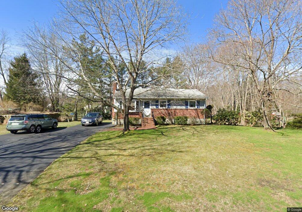
554 Whiting St Hanover, MA 02339
Estimated Value: $568,928 - $698,000
3
Beds
1
Bath
960
Sq Ft
$664/Sq Ft
Est. Value
About This Home
This home is located at 554 Whiting St, Hanover, MA 02339 and is currently estimated at $637,732, approximately $664 per square foot. 554 Whiting St is a home located in Plymouth County with nearby schools including Hanover High School, Calvary Chapel Academy, and Holy Family Elementary School.
Ownership History
Date
Name
Owned For
Owner Type
Purchase Details
Closed on
May 29, 2025
Sold by
Noiles Leonard A and Noiles Yvonne M
Bought by
Noiles
Current Estimated Value
Purchase Details
Closed on
Dec 2, 1969
Bought by
Noiles Leonard A and Noiles Yvonne M
Create a Home Valuation Report for This Property
The Home Valuation Report is an in-depth analysis detailing your home's value as well as a comparison with similar homes in the area
Home Values in the Area
Average Home Value in this Area
Purchase History
| Date | Buyer | Sale Price | Title Company |
|---|---|---|---|
| Noiles | -- | None Available | |
| Noiles | -- | None Available | |
| Noiles Leonard A | -- | -- |
Source: Public Records
Mortgage History
| Date | Status | Borrower | Loan Amount |
|---|---|---|---|
| Previous Owner | Noiles Leonard A | $237,000 | |
| Previous Owner | Noiles Leonard A | $50,000 |
Source: Public Records
Tax History
| Year | Tax Paid | Tax Assessment Tax Assessment Total Assessment is a certain percentage of the fair market value that is determined by local assessors to be the total taxable value of land and additions on the property. | Land | Improvement |
|---|---|---|---|---|
| 2025 | $6,452 | $522,400 | $269,400 | $253,000 |
| 2024 | $6,708 | $522,400 | $269,400 | $253,000 |
| 2023 | $6,120 | $453,700 | $244,900 | $208,800 |
| 2022 | $6,222 | $408,000 | $244,900 | $163,100 |
| 2021 | $7,670 | $381,000 | $222,600 | $158,400 |
| 2020 | $5,196 | $376,600 | $222,600 | $154,000 |
| 2019 | $5,893 | $359,100 | $222,600 | $136,500 |
| 2018 | $25,151 | $353,300 | $222,600 | $130,700 |
| 2017 | $5,417 | $327,900 | $209,500 | $118,400 |
| 2016 | $5,208 | $308,900 | $190,500 | $118,400 |
| 2015 | $4,759 | $294,700 | $190,500 | $104,200 |
Source: Public Records
Map
Nearby Homes
- 108 Deerfield Ln
- 641 Hingham St
- 375 Webster St
- 354 Webster St
- 10 Sunnybank Ave
- 48 Bigelow Ave
- 173 Liberty St
- 215 Vernon St
- 197 Juniper Ln Unit 197
- 214 Washington St Unit 28
- 411 Market St
- 86 Leisurewoods Dr Unit 279
- 823 Market St
- 11 Hawthorne St
- 1 Canterbury Ln
- 19 Hawthorne St
- 569 Main St
- 5 Crabapple Cir
- 11 Chestnut Cir
- 30 Leisurewoods Dr
- 555 Whiting St
- 542 Whiting St
- 564 Whiting St
- 23 Ponderosa Dr
- 545 Whiting St
- 565 Whiting St
- 37 Ponderosa Dr
- 578 Whiting St
- 535 Whiting St
- 575 Whiting St
- 570 Whiting St
- 47 Ponderosa Dr
- 518 Whiting St
- 22 Oldfield Dr
- 22 Ponderosa Dr
- 70 Holly Berry Ln
- 40 Ponderosa Dr
- 594 Whiting St
- 589 Whiting St
- 521 Whiting St
Your Personal Tour Guide
Ask me questions while you tour the home.