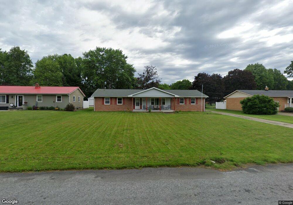
555 Franklin Dr Doylestown, OH 44230
Estimated Value: $241,000 - $285,000
3
Beds
2
Baths
1,344
Sq Ft
$199/Sq Ft
Est. Value
About This Home
This home is located at 555 Franklin Dr, Doylestown, OH 44230 and is currently estimated at $267,000, approximately $198 per square foot. 555 Franklin Dr is a home located in Wayne County with nearby schools including Hazel Harvey Elementary School, Chippewa Intermediate School, and Chippewa Jr./Sr. High School.
Ownership History
Date
Name
Owned For
Owner Type
Purchase Details
Closed on
Jul 27, 2023
Sold by
Browning Roger A and Browning Josette R
Bought by
Browning Roger A and Browning Josette R
Current Estimated Value
Home Financials for this Owner
Home Financials are based on the most recent Mortgage that was taken out on this home.
Original Mortgage
$259,000
Interest Rate
7.12%
Mortgage Type
Credit Line Revolving
Purchase Details
Closed on
Nov 14, 2007
Sold by
Browning Ronald L and Browning Roberta J
Bought by
Browning Roger A
Home Financials for this Owner
Home Financials are based on the most recent Mortgage that was taken out on this home.
Original Mortgage
$143,000
Interest Rate
6.45%
Mortgage Type
VA
Purchase Details
Closed on
Jun 7, 2005
Sold by
Perren Albert C
Bought by
Browning Ronald L and Browning Roberta J
Home Financials for this Owner
Home Financials are based on the most recent Mortgage that was taken out on this home.
Original Mortgage
$116,000
Interest Rate
5.87%
Mortgage Type
Fannie Mae Freddie Mac
Purchase Details
Closed on
Jul 21, 1999
Sold by
Sheppard Robert S
Bought by
Perren Albert C
Home Financials for this Owner
Home Financials are based on the most recent Mortgage that was taken out on this home.
Original Mortgage
$102,600
Interest Rate
7.54%
Mortgage Type
New Conventional
Create a Home Valuation Report for This Property
The Home Valuation Report is an in-depth analysis detailing your home's value as well as a comparison with similar homes in the area
Home Values in the Area
Average Home Value in this Area
Purchase History
| Date | Buyer | Sale Price | Title Company |
|---|---|---|---|
| Browning Roger A | -- | None Listed On Document | |
| Browning Roger A | $140,000 | Land America Lawyers Title | |
| Browning Ronald L | $145,000 | Landamerica-Lawyers Title | |
| Perren Albert C | $108,000 | -- |
Source: Public Records
Mortgage History
| Date | Status | Borrower | Loan Amount |
|---|---|---|---|
| Previous Owner | Browning Roger A | $259,000 | |
| Previous Owner | Browning Roger A | $143,000 | |
| Previous Owner | Browning Ronald L | $116,000 | |
| Previous Owner | Perren Albert C | $102,600 |
Source: Public Records
Tax History
| Year | Tax Paid | Tax Assessment Tax Assessment Total Assessment is a certain percentage of the fair market value that is determined by local assessors to be the total taxable value of land and additions on the property. | Land | Improvement |
|---|---|---|---|---|
| 2025 | $2,465 | $67,440 | $17,310 | $50,130 |
| 2024 | $2,465 | $67,440 | $17,310 | $50,130 |
| 2023 | $2,476 | $67,440 | $17,310 | $50,130 |
| 2022 | $1,979 | $49,230 | $12,640 | $36,590 |
| 2021 | $1,993 | $49,230 | $12,640 | $36,590 |
| 2020 | $2,006 | $49,230 | $12,640 | $36,590 |
| 2019 | $1,861 | $43,970 | $12,130 | $31,840 |
| 2018 | $1,878 | $43,970 | $12,130 | $31,840 |
| 2017 | $1,811 | $43,970 | $12,130 | $31,840 |
| 2016 | $1,767 | $41,070 | $12,130 | $28,940 |
| 2015 | $1,759 | $41,070 | $12,130 | $28,940 |
| 2014 | $1,558 | $41,070 | $12,130 | $28,940 |
| 2013 | $1,704 | $43,690 | $16,160 | $27,530 |
Source: Public Records
Map
Nearby Homes
- 0 S Portage St
- 204 Circle Dr
- 144 Church St
- 174 Circle Dr
- 100 Merlot Ct
- 15899 Mccallum Dr
- 0 Akron Rd Unit 5123781
- 680 Thorn Way
- 620 Thorn Way
- 500 W Clinton St
- 497 Gates St
- 15500 Freedom Dr
- 14525 Serfass Rd
- VL 1067 Homan Dr
- 233 Homan Dr
- V/L 1050 Melanie Ln
- 12045 Coal Bank Rd
- V/L approx 67.56ac Gates St
- 14831 Calaboone Rd
- 12214 Vince Dr
- 535 Franklin Dr
- 575 Franklin Dr
- 200 Maple St
- 230 Maple St
- 601 Franklin Dr
- 621 Franklin Dr
- 560 Franklin Dr
- 540 Franklin Dr
- 180 Maple St
- 580 Franklin Dr
- 520 Franklin Dr
- 641 Franklin Dr
- 195 Bailey Ct
- 600 Franklin Dr
- 320 Franklin Dr
- 10 Franklin Dr
- 235 Bailey Ct
- 240 Maple St
- 175 Bailey Ct
- 661 Franklin Dr
Your Personal Tour Guide
Ask me questions while you tour the home.