555 Ipswich Rd Boxford, MA 01921
Estimated Value: $1,201,000 - $1,413,000
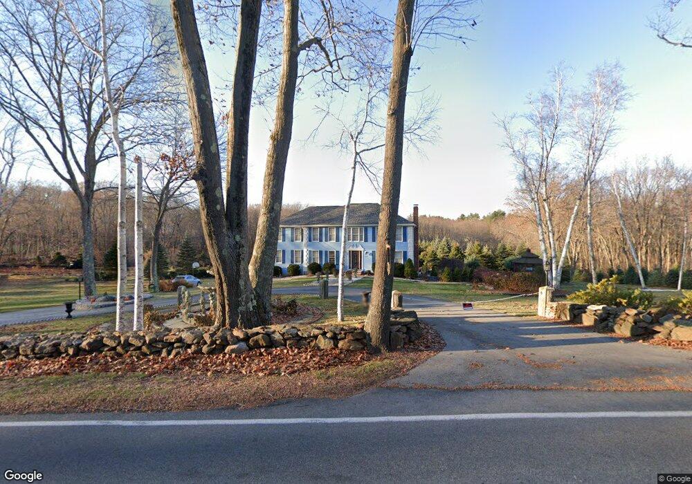
About This Home
This home is located at 555 Ipswich Rd, Boxford, MA 01921 and is currently estimated at $1,282,153, approximately $382 per square foot. 555 Ipswich Rd is a home located in Essex County with nearby schools including Harry Lee Cole, Spofford Pond School, and Brooks School.
Ownership History
We collect this data history from publicly available records. To have your information removed, we recommend requesting removal directly through your county’s website.
Purchase Details
Purchase Details
Home Financials for this Owner
Home Financials are based on the most recent Mortgage that was taken out on this home.Home Values in the Area
Average Home Value in this Area
Purchase History
We collect this data history from publicly available records. To have your information removed, we recommend requesting removal directly through your county’s website.
| Date | Buyer | Sale Price | Title Company |
|---|---|---|---|
| -- | None Available | ||
| $346,000 | -- |
Mortgage History
We collect this data history from publicly available records. To have your information removed, we recommend requesting removal directly through your county’s website.
| Date | Status | Borrower | Loan Amount |
|---|---|---|---|
| Previous Owner | $202,300 | ||
| Previous Owner | $270,000 |
Tax History
We collect this data history from publicly available records. To have your information removed, we recommend requesting removal directly through your county’s website.
| Year | Tax Paid | Tax Assessment Tax Assessment Total Assessment is a certain percentage of the fair market value that is determined by local assessors to be the total taxable value of land and additions on the property. | Land | Improvement |
|---|---|---|---|---|
| 2025 | $14,385 | $1,069,500 | $413,400 | $656,100 |
| 2024 | $13,957 | $1,069,500 | $413,400 | $656,100 |
| 2023 | $12,653 | $914,200 | $369,200 | $545,000 |
| 2022 | $12,251 | $804,900 | $310,000 | $494,900 |
| 2021 | $11,694 | $730,400 | $282,900 | $447,500 |
| 2020 | $11,814 | $730,600 | $282,900 | $447,700 |
| 2019 | $11,319 | $695,300 | $269,900 | $425,400 |
| 2018 | $11,123 | $686,600 | $269,900 | $416,700 |
| 2017 | $12,206 | $748,400 | $257,200 | $491,200 |
| 2016 | $11,751 | $713,900 | $257,200 | $456,700 |
| 2015 | $11,073 | $692,500 | $257,200 | $435,300 |
Map
- 26 Mount Vernon Rd
- 123 Washington St
- 610 Main St
- 351 Main St
- 33 Coventry Ln
- 0 Silvermine Rd
- 28 Deer Run Rd
- 90 Blue Ridge Rd
- Lot B Willow Ave
- 17 Adams Rd
- 6 Foster St
- 294 Bear Hill Rd
- 106 Spofford Rd
- 137 Spofford Rd
- 71 Regency Place
- 82 Spofford Rd
- 30 Anne Rd
- 94 Boxford St
- 770 Boxford St
- 29 Hoveys Pond Dr
- 541 Ipswich Rd
- 554 Ipswich Rd
- 546 Ipswich Rd
- 550 Ipswich Rd
- 537 Ipswich Rd
- 50 Glendale Rd
- 44 Glendale Rd
- 536 Ipswich Rd
- 6 Allen Cir
- 51 Glendale Rd
- 55 Glendale Rd
- 997 Dale St
- 1000 Dale St
- 19 Allen Cir
- 57 Glendale Rd
- 16 Macdonald Dr
- 38 Glendale Rd
- 532 Ipswich Rd
- 10 Allen Cir
- 0 Glendale Rd Unit 73283064
Ask me questions while you tour the home.