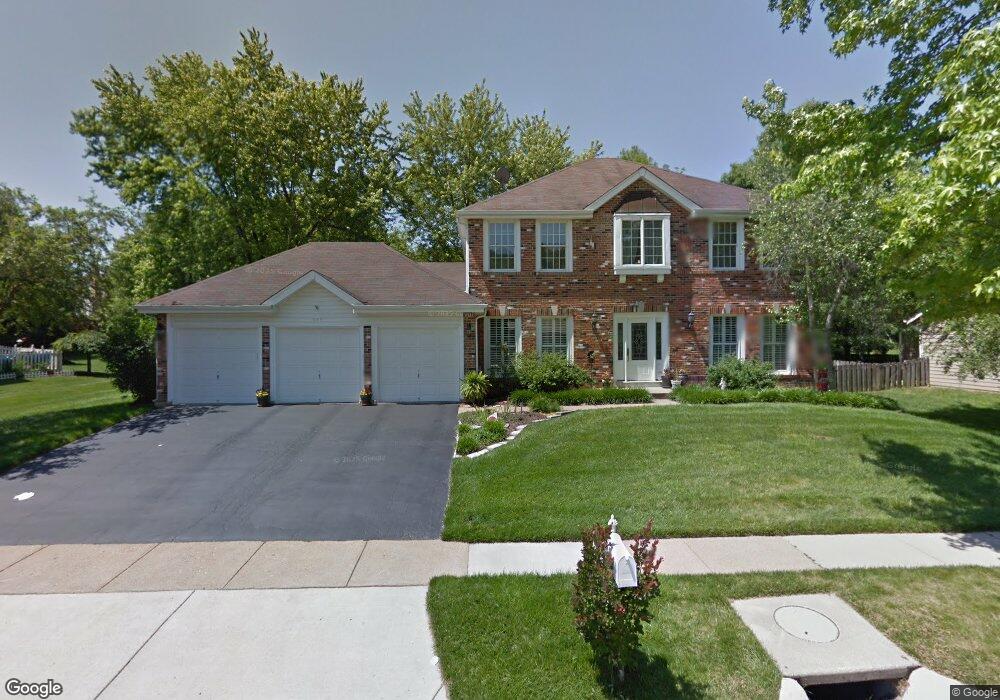
557 Red Rock Dr Ballwin, MO 63011
Estimated Value: $564,617 - $617,000
4
Beds
3
Baths
2,926
Sq Ft
$205/Sq Ft
Est. Value
About This Home
This home is located at 557 Red Rock Dr, Ballwin, MO 63011 and is currently estimated at $599,654, approximately $204 per square foot. 557 Red Rock Dr is a home located in St. Louis County with nearby schools including Babler Elementary School, Rockwood Valley Middle School, and Lafayette High School.
Ownership History
Date
Name
Owned For
Owner Type
Purchase Details
Closed on
Jan 30, 2013
Sold by
Horner Mark S and Horner Mary L
Bought by
Horner Mark S and Horner Mary L
Current Estimated Value
Home Financials for this Owner
Home Financials are based on the most recent Mortgage that was taken out on this home.
Original Mortgage
$263,000
Interest Rate
2.62%
Mortgage Type
New Conventional
Purchase Details
Closed on
Jul 13, 2005
Sold by
Horner Mark S and Horner Mary L
Bought by
Horner Mark S and Horner Mary L
Create a Home Valuation Report for This Property
The Home Valuation Report is an in-depth analysis detailing your home's value as well as a comparison with similar homes in the area
Home Values in the Area
Average Home Value in this Area
Purchase History
| Date | Buyer | Sale Price | Title Company |
|---|---|---|---|
| Horner Mark S | -- | Pulaski Title | |
| Horner Mark S | -- | -- |
Source: Public Records
Mortgage History
| Date | Status | Borrower | Loan Amount |
|---|---|---|---|
| Closed | Horner Mark S | $263,000 |
Source: Public Records
Tax History
| Year | Tax Paid | Tax Assessment Tax Assessment Total Assessment is a certain percentage of the fair market value that is determined by local assessors to be the total taxable value of land and additions on the property. | Land | Improvement |
|---|---|---|---|---|
| 2025 | $6,696 | $98,130 | $35,130 | $63,000 |
| 2024 | $6,696 | $96,290 | $24,150 | $72,140 |
| 2023 | $6,696 | $96,290 | $24,150 | $72,140 |
| 2022 | $6,053 | $80,920 | $15,370 | $65,550 |
| 2021 | $6,009 | $80,920 | $15,370 | $65,550 |
| 2020 | $6,130 | $78,710 | $12,100 | $66,610 |
| 2019 | $6,154 | $78,710 | $12,100 | $66,610 |
| 2018 | $6,203 | $74,800 | $15,370 | $59,430 |
| 2017 | $6,054 | $74,800 | $15,370 | $59,430 |
| 2016 | $5,845 | $69,450 | $17,580 | $51,870 |
| 2015 | $5,726 | $69,450 | $17,580 | $51,870 |
| 2014 | $5,336 | $63,120 | $8,990 | $54,130 |
Source: Public Records
Map
Nearby Homes
- 1640 Timber Hollow Dr
- 352 Strecker Rd
- 1670 Timber Ridge Estates Dr
- 1504 Englebrook Dr
- 215 Cobblefield Ct
- 16403 Prestwick Place Ln
- 305 Berry Brook Ct
- 16404 Clayton Rd
- 539 McBride Pointe Dr
- 16354 Clayton Rd
- 16342 Clayton Rd
- 583 McBride Pointe Dr
- 2466 Maple Crossing Dr
- 1525 Virginia Dr
- 16421 Hollister Crossing Dr
- 2213 Wood Dale Ridge Ct
- 2140 Dartmouth Gate Ct
- 2529 Westglen Farms Dr
- 16200 Wynncrest Ridge Ct
- 18024 Cider Mill Dr
- 563 Red Rock Dr
- 545 Red Rock Dr
- 548 Prospector Ridge Dr
- 541 Red Rock Dr
- 560 Red Rock Dr
- 554 Prospector Ridge Dr
- 542 Prospector Ridge Dr
- 533 Red Rock Dr
- 556 Red Rock Dr
- 569 Red Rock Dr
- 564 Red Rock Dr
- 560 Prospector Ridge Dr
- 536 Prospector Ridge Dr
- 548 Red Rock Dr
- 552 Red Rock Dr
- 544 Red Rock Dr
- 566 Prospector Ridge Dr
- 570 Red Rock Dr
- 549 Prospector Ridge Dr
- 543 Prospector Ridge Dr
Your Personal Tour Guide
Ask me questions while you tour the home.