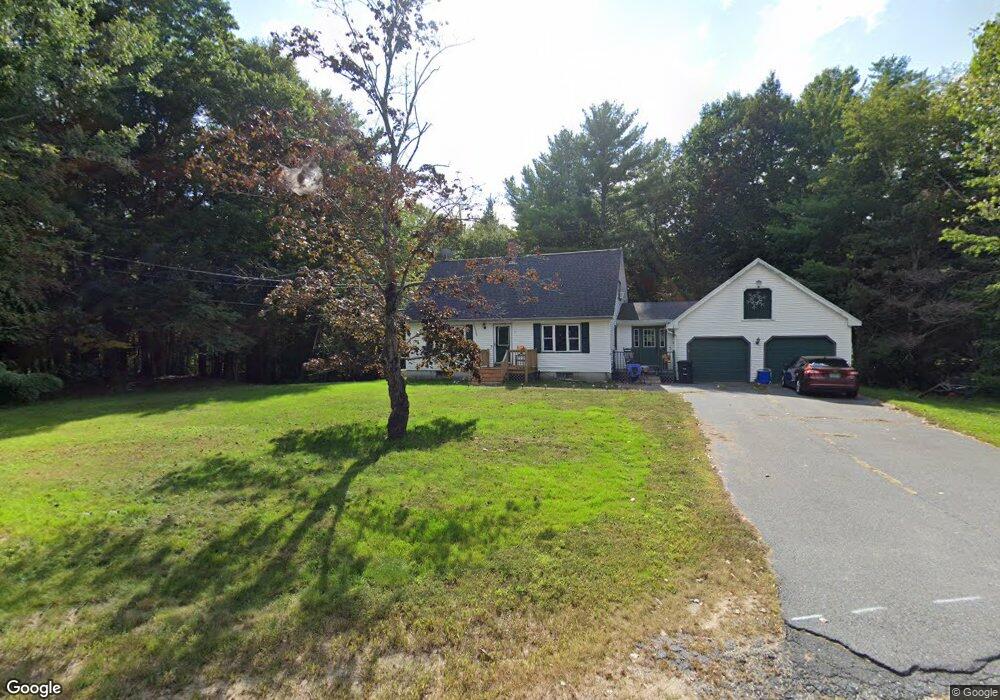
56 Kevin Cir Buxton, ME 04093
Estimated Value: $435,211 - $518,000
3
Beds
2
Baths
1,638
Sq Ft
$289/Sq Ft
Est. Value
About This Home
This home is located at 56 Kevin Cir, Buxton, ME 04093 and is currently estimated at $474,053, approximately $289 per square foot. 56 Kevin Cir is a home located in York County with nearby schools including Bonny Eagle High School.
Ownership History
Date
Name
Owned For
Owner Type
Purchase Details
Closed on
Mar 9, 2022
Sold by
Chadbourne James P
Bought by
Chadbourne Heather M
Current Estimated Value
Home Financials for this Owner
Home Financials are based on the most recent Mortgage that was taken out on this home.
Original Mortgage
$195,000
Outstanding Balance
$180,548
Interest Rate
3.92%
Mortgage Type
Purchase Money Mortgage
Estimated Equity
$293,505
Create a Home Valuation Report for This Property
The Home Valuation Report is an in-depth analysis detailing your home's value as well as a comparison with similar homes in the area
Home Values in the Area
Average Home Value in this Area
Purchase History
We collect this data history from publicly available records. To have your information removed, we recommend requesting removal directly through your county’s website.
| Date | Buyer | Sale Price | Title Company |
|---|---|---|---|
| Chadbourne Heather M | -- | None Available |
Source: Public Records
Mortgage History
We collect this data history from publicly available records. To have your information removed, we recommend requesting removal directly through your county’s website.
| Date | Status | Borrower | Loan Amount |
|---|---|---|---|
| Open | Chadbourne Heather M | $195,000 |
Source: Public Records
Tax History
| Year | Tax Paid | Tax Assessment Tax Assessment Total Assessment is a certain percentage of the fair market value that is determined by local assessors to be the total taxable value of land and additions on the property. | Land | Improvement |
|---|---|---|---|---|
| 2025 | $3,631 | $318,500 | $100,200 | $218,300 |
| 2024 | $3,500 | $318,500 | $100,200 | $218,300 |
| 2023 | $3,304 | $316,800 | $100,200 | $216,600 |
| 2022 | $3,275 | $319,800 | $100,200 | $219,600 |
| 2021 | $2,987 | $206,586 | $61,100 | $145,486 |
| 2020 | $3,012 | $206,586 | $61,100 | $145,486 |
| 2019 | $2,731 | $184,300 | $61,100 | $123,200 |
| 2018 | $2,606 | $184,300 | $61,100 | $123,200 |
| 2017 | $2,506 | $184,300 | $61,100 | $123,200 |
| 2016 | $2,405 | $184,300 | $61,100 | $123,200 |
| 2015 | $2,387 | $184,300 | $61,100 | $123,200 |
| 2014 | $2,341 | $184,300 | $61,100 | $123,200 |
| 2013 | $2,304 | $184,300 | $61,100 | $123,200 |
Source: Public Records
Map
Nearby Homes
- 866 Parker Farm Lot A Rd
- 866 Parker Farm Lot B Rd
- 866 Parker Farm Rd Unit A
- 866 Parker Farm Rd Unit B
- 8 Elliott Rd
- Lot 2 Commerce Way
- 30 Joan Dixon Way
- 159 Henry Hill Rd
- 157 Long Plains Rd
- 10 Old Orchard Rd
- 32 Spiller Rd
- 16 Captain's Way
- 252 Ossipee Trail E
- 3 Cortland Place Unit 8
- TBD Saco Rd
- 63 Ossipee Trail E
- 13 Cider Mill Ln
- 27 Ossipee Trail E Unit 1
- 15 Ossipee Trail E
- 60 Ossipee Trail W
Your Personal Tour Guide
Ask me questions while you tour the home.