
Seller's Agent in 2025
Heather Dacey
William Raveis Real Estate
(203) 314-1301
4 in this area
85 Total Sales
Estimated Value: $519,708 - $604,000
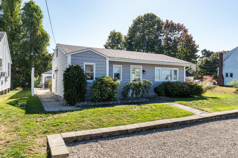
Charming and completely turn-key, this year-round Harborview beach house is your little piece of perfect! Whether you're dreaming of single-floor living, a relaxing vacation retreat, or an ideal investment opportunity, this 2-3 bedroom, 811 sq ft gem checks every box. Thoughtfully gut-renovated, the home features low-maintenance vinyl shake siding, a newer roof and windows, updated electric, and a bright, open floor plan that feels airy and inviting. The updated kitchen and bath add a modern touch, while sunlit interiors capture the essence of the beach house lifestyle with year-round comfort. Step outside to your own coastal oasis-complete with a Barnyard pavilion featuring Trex decking, a firepit for evening gatherings, a patio, outdoor shower, shed, and ample parking. Located within the sought-after Harborview Association, you'll enjoy access to two private beaches and a scenic waterfront path leading right to Clinton Town Beach-perfect for evening walks, viewing sunsets or grabbing ice cream cones by the shore. With its charm, updates, and unbeatable location, this beachside retreat is ready for you to move in and start making memories!
Last Agent to Sell the Property
William Raveis Real Estate Brokerage Phone: (203) 314-1301 License #REB.0793752 Listed on: 10/09/2025
We collect this data history from publicly available records. To have your information removed, we recommend requesting removal directly through your county’s website.
| Date | Buyer | Sale Price | Title Company |
|---|---|---|---|
| Vigeant Michael | $539,000 | -- | |
| Ian James | $267,000 | -- | |
| Ian James | $267,000 | -- | |
| Dehestani Amir | $250,000 | -- | |
| Dehestani Amir | $250,000 | -- |
We collect this data history from publicly available records. To have your information removed, we recommend requesting removal directly through your county’s website.
| Date | Status | Borrower | Loan Amount |
|---|---|---|---|
| Open | Vigeant Michael | $431,200 | |
| Previous Owner | Dehestani Amir | $204,000 | |
| Previous Owner | Dehestani Amir | $214,000 | |
| Previous Owner | Dehestani Amir | $225,000 |
| Date | Event | Price | List to Sale | Price per Sq Ft |
|---|---|---|---|---|
| 11/21/2025 11/21/25 | Sold | $539,000 | 0.0% | $665 / Sq Ft |
| 11/13/2025 11/13/25 | Pending | -- | -- | -- |
| 10/16/2025 10/16/25 | For Sale | $539,000 | -- | $665 / Sq Ft |
| Year | Tax Paid | Tax Assessment Tax Assessment Total Assessment is a certain percentage of the fair market value that is determined by local assessors to be the total taxable value of land and additions on the property. | Land | Improvement |
|---|---|---|---|---|
| 2025 | $5,605 | $180,000 | $116,500 | $63,500 |
| 2024 | $5,447 | $180,000 | $116,500 | $63,500 |
| 2023 | $5,369 | $180,000 | $116,500 | $63,500 |
| 2022 | $5,369 | $180,000 | $116,500 | $63,500 |
| 2021 | $4,227 | $141,700 | $83,800 | $57,900 |
| 2020 | $4,428 | $141,700 | $83,800 | $57,900 |
| 2019 | $4,428 | $141,700 | $83,800 | $57,900 |
| 2018 | $4,328 | $141,700 | $83,800 | $57,900 |
| 2017 | $4,238 | $141,700 | $83,800 | $57,900 |
| 2016 | $3,846 | $141,700 | $83,800 | $57,900 |
| 2015 | $3,933 | $146,900 | $83,800 | $63,100 |
| 2014 | $3,859 | $146,900 | $83,800 | $63,100 |
Seller's Agent in 2025
Heather Dacey
William Raveis Real Estate
(203) 314-1301
4 in this area
85 Total Sales
Buyer's Agent in 2025
Kevin Geysen
William Pitt
(860) 805-0000
5 in this area
64 Total Sales
Source: SmartMLS
MLS Number: 24131679
APN: CLIN-000069-000066-000099
Disclaimer: Certain information contained herein is derived from information provided by parties other than Homes.com. All information provided is deemed reliable, but is not guaranteed to be accurate and should be independently verified.
![]() IDX information is provided exclusively for personal, non-commercial use, and may not be used for any purpose other than to identify prospective properties consumers may be interested in purchasing. Information is deemed reliable but not guaranteed.
IDX information is provided exclusively for personal, non-commercial use, and may not be used for any purpose other than to identify prospective properties consumers may be interested in purchasing. Information is deemed reliable but not guaranteed.
Ask me questions while you tour the home.