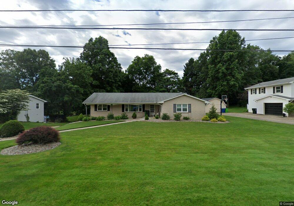
560 Franklin Dr Doylestown, OH 44230
Estimated Value: $267,047 - $334,000
3
Beds
2
Baths
1,967
Sq Ft
$152/Sq Ft
Est. Value
About This Home
This home is located at 560 Franklin Dr, Doylestown, OH 44230 and is currently estimated at $298,262, approximately $151 per square foot. 560 Franklin Dr is a home located in Wayne County with nearby schools including Hazel Harvey Elementary School, Chippewa Intermediate School, and Chippewa Jr./Sr. High School.
Ownership History
Date
Name
Owned For
Owner Type
Purchase Details
Closed on
Mar 11, 2021
Sold by
Hosey Leon D and Hosey Charlotte A
Bought by
Crowder Lynn A and Hosey Charlotte A
Current Estimated Value
Purchase Details
Closed on
May 26, 2016
Sold by
Hosey Charlotte A
Bought by
Hosey Leon D and Hosey Charlotte A
Purchase Details
Closed on
Oct 11, 1991
Sold by
Hosey Leon D and Hosey Charlotte
Bought by
Hosey Leon D and Hosey Charlotte
Create a Home Valuation Report for This Property
The Home Valuation Report is an in-depth analysis detailing your home's value as well as a comparison with similar homes in the area
Home Values in the Area
Average Home Value in this Area
Purchase History
| Date | Buyer | Sale Price | Title Company |
|---|---|---|---|
| Crowder Lynn A | -- | Heartland Title Agency | |
| Hosey Leon D | -- | Attorney | |
| Hosey Leon D | -- | -- |
Source: Public Records
Tax History
| Year | Tax Paid | Tax Assessment Tax Assessment Total Assessment is a certain percentage of the fair market value that is determined by local assessors to be the total taxable value of land and additions on the property. | Land | Improvement |
|---|---|---|---|---|
| 2025 | $2,289 | $72,740 | $17,960 | $54,780 |
| 2024 | $2,289 | $72,740 | $17,960 | $54,780 |
| 2023 | $2,312 | $72,740 | $17,960 | $54,780 |
| 2022 | $1,783 | $53,090 | $13,110 | $39,980 |
| 2021 | $1,796 | $53,090 | $13,110 | $39,980 |
| 2020 | $1,809 | $53,090 | $13,110 | $39,980 |
| 2019 | $1,577 | $45,970 | $12,590 | $33,380 |
| 2018 | $1,592 | $45,970 | $12,590 | $33,380 |
| 2017 | $1,580 | $45,970 | $12,590 | $33,380 |
| 2016 | $1,473 | $42,940 | $12,590 | $30,350 |
| 2015 | $1,467 | $42,940 | $12,590 | $30,350 |
| 2014 | $1,299 | $42,940 | $12,590 | $30,350 |
| 2013 | $1,508 | $47,350 | $16,760 | $30,590 |
Source: Public Records
Map
Nearby Homes
- 0 S Portage St
- 228 S Portage St
- 84 S Portage St
- 168 Huffman Ave
- 204 Circle Dr
- 174 Circle Dr
- 144 Church St
- 220 Catawba Path
- 15899 Mccallum Dr
- 0 Akron Rd Unit 5123781
- 680 Thorn Way
- 620 Thorn Way
- 500 W Clinton St
- 669 Summit St
- 15500 Freedom Dr
- 14525 Serfass Rd
- 12045 Coal Bank Rd
- V/L 1050 Melanie Ln
- V/L approx 67.56ac Gates St
- 14831 Calaboone Rd
- 580 Franklin Dr
- 540 Franklin Dr
- 600 Franklin Dr
- 520 Franklin Dr
- 240 Maple St
- 555 Franklin Dr
- 535 Franklin Dr
- 575 Franklin Dr
- 601 Franklin Dr
- 230 Maple St
- 620 Franklin Dr
- 621 Franklin Dr
- 325 Franklin Dr
- 200 Maple St
- 640 Franklin Dr
- 320 Franklin Dr
- 250 Maple St
- 641 Franklin Dr
- 660 Franklin Dr
- 305 Franklin Dr
Your Personal Tour Guide
Ask me questions while you tour the home.