Estimated Value: $280,000 - $321,000
3
Beds
2
Baths
1,402
Sq Ft
$220/Sq Ft
Est. Value
About This Home
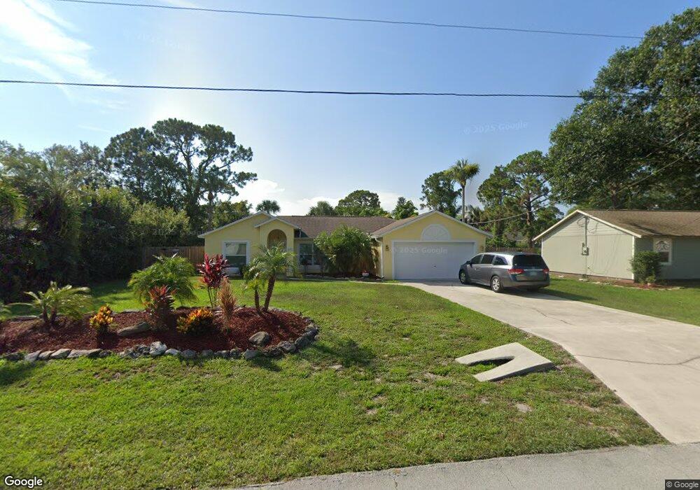
This home is located at 5632 Flint Rd, Cocoa, FL 32927 and is currently estimated at $308,385, approximately $219 per square foot. 5632 Flint Rd is a home located in Brevard County with nearby schools including Enterprise Elementary School, Space Coast Junior/Senior High School, and East Atlantic Prep of Brevard County.
Ownership History
Date
Name
Owned For
Owner Type
Purchase Details
Closed on
Feb 10, 2006
Sold by
Spinale Christopher and Spinale April C
Bought by
Bentley James L and Bentley Roberta K
Current Estimated Value
Home Financials for this Owner
Home Financials are based on the most recent Mortgage that was taken out on this home.
Original Mortgage
$198,400
Outstanding Balance
$119,902
Interest Rate
7.47%
Estimated Equity
$188,483
Purchase Details
Closed on
Oct 15, 1998
Sold by
Holiday Bldr Inc
Bought by
Boody April C
Home Financials for this Owner
Home Financials are based on the most recent Mortgage that was taken out on this home.
Original Mortgage
$77,100
Interest Rate
6.8%
Purchase Details
Closed on
Jun 29, 1998
Sold by
Delbusso Rita and Delbusso John
Bought by
Holiday Bldr Ins
Create a Home Valuation Report for This Property
The Home Valuation Report is an in-depth analysis detailing your home's value as well as a comparison with similar homes in the area
Home Values in the Area
Average Home Value in this Area
Purchase History
We collect this data history from publicly available records. To have your information removed, we recommend requesting removal directly through your county’s website.
| Date | Buyer | Sale Price | Title Company |
|---|---|---|---|
| Bentley James L | $248,000 | Liberty Title | |
| Boody April C | $77,700 | -- | |
| Holiday Bldr Ins | $9,200 | -- |
Source: Public Records
Mortgage History
We collect this data history from publicly available records. To have your information removed, we recommend requesting removal directly through your county’s website.
| Date | Status | Borrower | Loan Amount |
|---|---|---|---|
| Open | Bentley James L | $198,400 | |
| Previous Owner | Boody April C | $77,100 |
Source: Public Records
Tax History
| Year | Tax Paid | Tax Assessment Tax Assessment Total Assessment is a certain percentage of the fair market value that is determined by local assessors to be the total taxable value of land and additions on the property. | Land | Improvement |
|---|---|---|---|---|
| 2025 | $1,396 | $101,490 | -- | -- |
| 2024 | $1,359 | $98,630 | -- | -- |
| 2023 | $1,359 | $95,760 | $0 | $0 |
| 2022 | $1,266 | $92,980 | $0 | $0 |
| 2021 | $1,256 | $89,870 | $0 | $0 |
| 2020 | $1,192 | $88,630 | $0 | $0 |
| 2019 | $1,127 | $86,640 | $0 | $0 |
| 2018 | $1,119 | $85,030 | $0 | $0 |
| 2017 | $1,109 | $83,290 | $0 | $0 |
| 2016 | $1,108 | $81,580 | $18,000 | $63,580 |
| 2015 | $1,118 | $81,020 | $15,000 | $66,020 |
| 2014 | $1,118 | $80,380 | $11,000 | $69,380 |
Source: Public Records
Map
Nearby Homes
- 6438 Hudson Rd
- 5614 Jamaica Rd
- No Access W
- 6460 Irving Rd
- 5525 Fairbridge St
- 5424 Flint Rd
- 6250 Ainsworth Rd
- 5687 Holden Rd
- 5946 Deer Ln
- 5770 Fairbridge St
- 0 Aruin St Unit 1222557
- 6570 Bancroft Ave
- 6460 Ainsworth Rd
- 6581 Bancroft Ave
- 5945 Coker Ave
- 6450 Ember Ave
- 23-35-21-JX-B-2 Aruin St
- 5220 Holden Rd
- 5221 Carrick Rd
- 5975 Aruin St
Your Personal Tour Guide
Ask me questions while you tour the home.