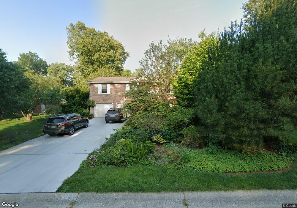
564 N Sands Ave Monroe, OH 45050
Estimated Value: $307,000 - $325,778
About This Home
This home is located at 564 N Sands Ave, Monroe, OH 45050 and is currently estimated at $317,945, approximately $210 per square foot. 564 N Sands Ave is a home located in Butler County with nearby schools including Monroe Primary School, Monroe Elementary School, and Monroe Junior High School.
Ownership History
We collect this data history from publicly available records. To have your information removed, we recommend requesting removal directly through your county’s website.
Purchase Details
Home Financials for this Owner
Home Financials are based on the most recent Mortgage that was taken out on this home.Purchase Details
Home Values in the Area
Average Home Value in this Area
Purchase History
We collect this data history from publicly available records. To have your information removed, we recommend requesting removal directly through your county’s website.
| Date | Buyer | Sale Price | Title Company |
|---|---|---|---|
| $138,000 | -- | ||
| $93,000 | -- |
Mortgage History
We collect this data history from publicly available records. To have your information removed, we recommend requesting removal directly through your county’s website.
| Date | Status | Borrower | Loan Amount |
|---|---|---|---|
| Open | $128,400 |
Tax History
We collect this data history from publicly available records. To have your information removed, we recommend requesting removal directly through your county’s website.
| Year | Tax Paid | Tax Assessment Tax Assessment Total Assessment is a certain percentage of the fair market value that is determined by local assessors to be the total taxable value of land and additions on the property. | Land | Improvement |
|---|---|---|---|---|
| 2025 | $3,920 | $87,030 | $13,000 | $74,030 |
| 2024 | $3,920 | $87,030 | $13,000 | $74,030 |
| 2023 | $3,894 | $88,460 | $13,000 | $75,460 |
| 2022 | $3,051 | $60,080 | $13,000 | $47,080 |
| 2021 | $2,940 | $60,080 | $13,000 | $47,080 |
| 2020 | $3,045 | $60,080 | $13,000 | $47,080 |
| 2019 | $3,647 | $53,190 | $12,870 | $40,320 |
| 2018 | $2,910 | $53,190 | $12,870 | $40,320 |
| 2017 | $2,972 | $53,190 | $12,870 | $40,320 |
| 2016 | $2,810 | $48,220 | $12,870 | $35,350 |
| 2015 | $2,779 | $48,220 | $12,870 | $35,350 |
| 2014 | $2,744 | $48,220 | $12,870 | $35,350 |
| 2013 | $2,744 | $47,250 | $12,870 | $34,380 |
Map
- 360 Britton Ln
- 44 Ridge Wood Dr
- 309 Slate Branch Ct
- 844 Heritage Green Dr Unit 4305
- 110 Nettleton Ct
- 1545 Weatherstone Cir Unit 12302
- 1755 Weatherstone Cir Unit 13304
- 340 MacReady Ave
- 100 N Main St
- 32 W Elm St
- 940 Sleepy Hollow Dr
- 3 Lebanon St
- 265 Easton Manor Dr
- 255 Easton Manor Dr
- 220 Sands Ave
- 230 Meadowlark Ln
- 295 Rachel Ln
- 8260 Streamside Dr
- 3332 Blue Springs Dr
- 513 Austin Smith Dr
- 552 N Sands Ave
- 544 N Sands Ave
- 17 Ravenwood Ct
- 536 N Sands Ave
- 551 N Sands Ave
- 23 Ravenwood Ct
- 559 N Sands Ave
- 543 N Sands Ave
- 574 N Sands Ave
- 16 Ravenwood Ct
- 567 N Sands Ave
- 535 N Sands Ave
- 32 Heatherwood Ct
- 10 Heatherwood Ct
- 22 Ravenwood Ct
- 26 Heatherwood Ct
- 38 Heatherwood Ct
- 575 N Sands Ave
- 527 N Sands Ave
- 537 Fox Run Place
Ask me questions while you tour the home.