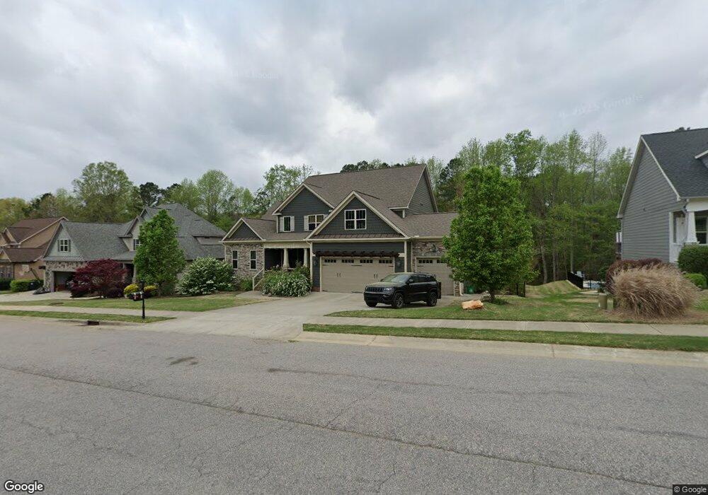
566 Fieldtrial Cir Garner, NC 27529
Estimated Value: $618,000 - $771,000
4
Beds
4
Baths
3,312
Sq Ft
$201/Sq Ft
Est. Value
About This Home
This home is located at 566 Fieldtrial Cir, Garner, NC 27529 and is currently estimated at $665,408, approximately $200 per square foot. 566 Fieldtrial Cir is a home located in Johnston County with nearby schools including West View Elementary School, Cleveland Middle School, and West Johnston High School.
Ownership History
Date
Name
Owned For
Owner Type
Purchase Details
Closed on
Feb 3, 2016
Sold by
Bls Inc
Bought by
Wiley Patrick J and Wiley Bonnie J
Current Estimated Value
Home Financials for this Owner
Home Financials are based on the most recent Mortgage that was taken out on this home.
Original Mortgage
$337,461
Outstanding Balance
$269,279
Interest Rate
3.98%
Mortgage Type
New Conventional
Estimated Equity
$396,129
Purchase Details
Closed on
Sep 16, 2015
Sold by
Dj 4042 Inc
Bought by
Bls Inc
Home Financials for this Owner
Home Financials are based on the most recent Mortgage that was taken out on this home.
Original Mortgage
$197,285
Interest Rate
3.94%
Mortgage Type
Construction
Create a Home Valuation Report for This Property
The Home Valuation Report is an in-depth analysis detailing your home's value as well as a comparison with similar homes in the area
Home Values in the Area
Average Home Value in this Area
Purchase History
We collect this data history from publicly available records. To have your information removed, we recommend requesting removal directly through your county’s website.
| Date | Buyer | Sale Price | Title Company |
|---|---|---|---|
| Wiley Patrick J | $375,000 | None Available | |
| Bls Inc | $53,000 | None Available |
Source: Public Records
Mortgage History
We collect this data history from publicly available records. To have your information removed, we recommend requesting removal directly through your county’s website.
| Date | Status | Borrower | Loan Amount |
|---|---|---|---|
| Open | Wiley Patrick J | $337,461 | |
| Previous Owner | Bls Inc | $197,285 |
Source: Public Records
Tax History
| Year | Tax Paid | Tax Assessment Tax Assessment Total Assessment is a certain percentage of the fair market value that is determined by local assessors to be the total taxable value of land and additions on the property. | Land | Improvement |
|---|---|---|---|---|
| 2025 | $4,147 | $653,090 | $75,000 | $578,090 |
| 2024 | $3,465 | $427,780 | $50,000 | $377,780 |
| 2023 | $3,347 | $427,780 | $50,000 | $377,780 |
| 2022 | $3,154 | $383,460 | $50,000 | $333,460 |
| 2021 | $3,154 | $383,460 | $50,000 | $333,460 |
| 2020 | $3,192 | $383,460 | $50,000 | $333,460 |
| 2019 | $3,192 | $383,460 | $50,000 | $333,460 |
| 2018 | $2,968 | $348,160 | $50,000 | $298,160 |
| 2017 | $2,968 | $348,160 | $50,000 | $298,160 |
| 2016 | $1,880 | $220,570 | $50,000 | $170,570 |
Source: Public Records
Map
Nearby Homes
- 267 Meadowmist Dr
- 210 Ivey Gate Ln
- 36 Miry Branch Ct
- 58 Trailblazer Ln
- 41 Gladwood Way
- 13 W Currituck Cir
- 188 Flight Pattern Way
- 107 Gibbons Dr
- 113 Linden Ct
- 112 Gibbons Dr
- 320 Black Angus Dr
- 304 Artic Cir
- 102 Sherrill Place Ln
- 17 Belgian Blue Dr
- 121 Telluride Trail
- 125 Wolf Den Dr
- 0 Southfort Dr
- 222 Dana Dr
- 170 Sallyport Ct
- 500 Hillcrest Dr
- 594 Fieldtrial Cir
- 540 Fieldtrial Cir
- 520 Fieldtrial Cir
- 624 Fieldtrial Cir
- 571 Fieldtrial Cir
- 338 Meadowmist Dr
- 629 Fieldtrial Cir
- 632 Fieldtrial Cir
- 500 Fieldtrial Cir
- 503 Fieldtrial Cir
- 323 Meadowmist Dr
- 490 Fieldtrial Cir
- 671 Fieldtrial Cir
- 483 Fieldtrial Cir
- 294 Meadowmist Dr Unit Lt151
- 294 Meadowmist Dr
- 662 Fieldtrial Cir
- 305 Meadowmist Dr
- 480 Fieldtrial Cir
- 278 Suntree Ln
Your Personal Tour Guide
Ask me questions while you tour the home.