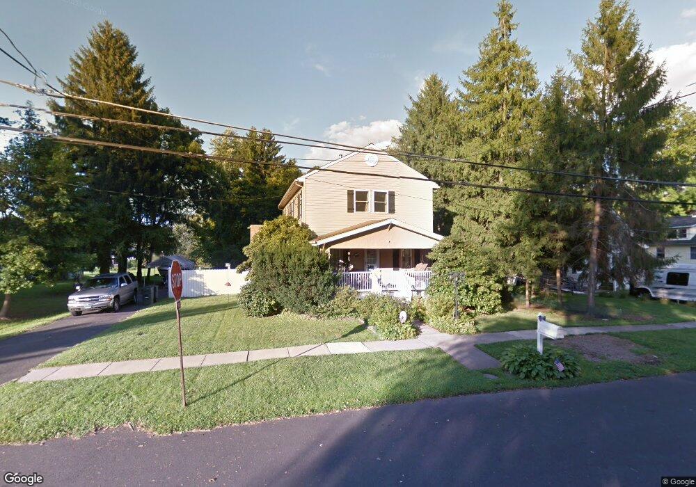
57 Chase Ave Warminster, PA 18974
Estimated Value: $474,231 - $582,000
3
Beds
2
Baths
2,112
Sq Ft
$249/Sq Ft
Est. Value
About This Home
This home is located at 57 Chase Ave, Warminster, PA 18974 and is currently estimated at $525,808, approximately $248 per square foot. 57 Chase Ave is a home located in Bucks County with nearby schools including McDonald Elementary School, Log College Middle School, and William Tennent High School.
Ownership History
Date
Name
Owned For
Owner Type
Purchase Details
Closed on
Oct 19, 2001
Sold by
Linwood Jennifer L and Linwood William C
Bought by
Linwood William C and Linwood Jennifer L
Current Estimated Value
Home Financials for this Owner
Home Financials are based on the most recent Mortgage that was taken out on this home.
Original Mortgage
$164,900
Outstanding Balance
$63,651
Interest Rate
6.7%
Estimated Equity
$462,157
Purchase Details
Closed on
Apr 24, 1995
Sold by
Bristow Eric P and Bristow Eileen G
Bought by
Hahn Jennifer L and Linwood William C
Home Financials for this Owner
Home Financials are based on the most recent Mortgage that was taken out on this home.
Original Mortgage
$115,200
Interest Rate
8.37%
Create a Home Valuation Report for This Property
The Home Valuation Report is an in-depth analysis detailing your home's value as well as a comparison with similar homes in the area
Home Values in the Area
Average Home Value in this Area
Purchase History
| Date | Buyer | Sale Price | Title Company |
|---|---|---|---|
| Linwood William C | -- | First American Title Ins Co | |
| Hahn Jennifer L | $128,000 | -- |
Source: Public Records
Mortgage History
| Date | Status | Borrower | Loan Amount |
|---|---|---|---|
| Open | Linwood William C | $164,900 | |
| Closed | Hahn Jennifer L | $115,200 |
Source: Public Records
Tax History
| Year | Tax Paid | Tax Assessment Tax Assessment Total Assessment is a certain percentage of the fair market value that is determined by local assessors to be the total taxable value of land and additions on the property. | Land | Improvement |
|---|---|---|---|---|
| 2025 | $4,435 | $22,120 | $4,960 | $17,160 |
| 2024 | $4,435 | $22,120 | $4,960 | $17,160 |
| 2023 | $4,291 | $22,120 | $4,960 | $17,160 |
| 2022 | $4,195 | $22,120 | $4,960 | $17,160 |
| 2021 | $4,113 | $22,120 | $4,960 | $17,160 |
| 2020 | $4,053 | $22,120 | $4,960 | $17,160 |
| 2019 | $3,959 | $22,120 | $4,960 | $17,160 |
| 2018 | $3,862 | $22,120 | $4,960 | $17,160 |
| 2017 | $3,747 | $22,120 | $4,960 | $17,160 |
| 2016 | $3,747 | $22,120 | $4,960 | $17,160 |
| 2015 | -- | $22,120 | $4,960 | $17,160 |
| 2014 | -- | $22,120 | $4,960 | $17,160 |
Source: Public Records
Map
Nearby Homes
- 1000 Jacksonville Rd Unit 18
- 111 Grandview Dr
- 55 Parry Way
- 12 Spring Mill Dr
- 86 Parry Way
- 9 Spring Dr
- 11 Spring Dr
- 15 Spring Mill Dr
- 21 Spring Mill Dr Unit 12
- 1192 Harper Dr
- 1012 Mearns Rd
- 854 Phillips Rd
- 403 Byron Rd
- 538 Parmentier Rd
- 1087 Roberts Rd
- 304 Julian Dr E
- 104 Shannon Ct
- 786 Boxwood Dr
- 632 Longfellow Ct
- 982 Mueller Rd
Your Personal Tour Guide
Ask me questions while you tour the home.