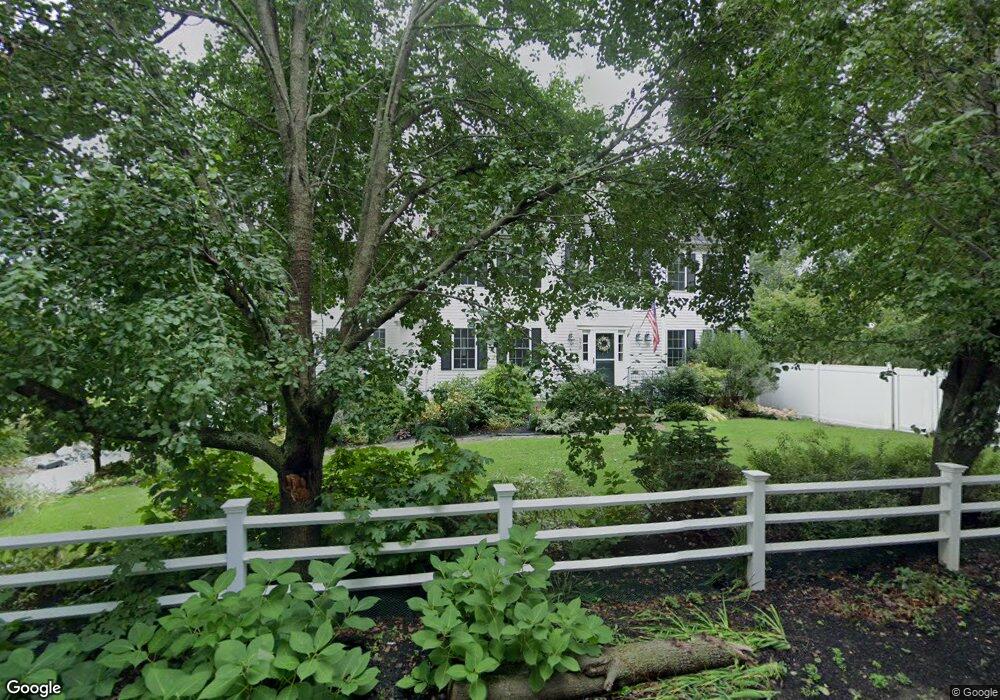
570 Hancock St Wrentham, MA 02093
West Wrentham NeighborhoodEstimated Value: $782,000 - $1,003,000
4
Beds
3
Baths
2,624
Sq Ft
$328/Sq Ft
Est. Value
About This Home
This home is located at 570 Hancock St, Wrentham, MA 02093 and is currently estimated at $861,008, approximately $328 per square foot. 570 Hancock St is a home located in Norfolk County with nearby schools including Delaney Elementary School and Charles E Roderick.
Ownership History
Date
Name
Owned For
Owner Type
Purchase Details
Closed on
Mar 8, 2023
Sold by
Medeiros Lawrence S
Bought by
Medeiros Lt
Current Estimated Value
Purchase Details
Closed on
Mar 13, 2008
Sold by
Germansderfer Abe and Germansderfer Alla
Bought by
Medeiros Lawrence S
Purchase Details
Closed on
May 14, 2004
Sold by
Schmitz Danielle L and Schmitz Paul R
Bought by
Germansderfer Abe and Germansderfer Alla
Purchase Details
Closed on
Jun 6, 2003
Sold by
Colley Donald G and Colley Dorothy H
Bought by
Carroll John T and Hayes Dennis
Purchase Details
Closed on
May 6, 2002
Sold by
Brunelli Prop Inc
Bought by
Schmitz Paul R
Purchase Details
Closed on
Mar 12, 2002
Sold by
Brunelli Properties
Bought by
Carroll John T and Carroll Jennifer C
Purchase Details
Closed on
Nov 13, 2000
Sold by
Carroll John T and Carroll Jennifer C
Bought by
Brunelli Prop Inc
Purchase Details
Closed on
Jul 26, 2000
Sold by
Gaulin Tr Lynn A and Gaulin Lynn A
Bought by
Carroll John T and Carroll Jennifer C
Create a Home Valuation Report for This Property
The Home Valuation Report is an in-depth analysis detailing your home's value as well as a comparison with similar homes in the area
Home Values in the Area
Average Home Value in this Area
Purchase History
| Date | Buyer | Sale Price | Title Company |
|---|---|---|---|
| Medeiros Lt | -- | None Available | |
| Medeiros Lawrence S | $435,000 | -- | |
| Germansderfer Abe | $505,000 | -- | |
| Carroll John T | $400,000 | -- | |
| Schmitz Paul R | $415,500 | -- | |
| Carroll John T | $20,500 | -- | |
| Brunelli Prop Inc | $105,000 | -- | |
| Carroll John T | $105,000 | -- |
Source: Public Records
Mortgage History
| Date | Status | Borrower | Loan Amount |
|---|---|---|---|
| Previous Owner | Carroll John T | $332,000 | |
| Previous Owner | Carroll John T | $332,000 |
Source: Public Records
Tax History
| Year | Tax Paid | Tax Assessment Tax Assessment Total Assessment is a certain percentage of the fair market value that is determined by local assessors to be the total taxable value of land and additions on the property. | Land | Improvement |
|---|---|---|---|---|
| 2025 | $9,177 | $791,800 | $248,400 | $543,400 |
| 2024 | $8,677 | $723,100 | $248,400 | $474,700 |
| 2023 | $8,213 | $650,800 | $225,900 | $424,900 |
| 2022 | $8,030 | $587,400 | $211,000 | $376,400 |
| 2021 | $7,466 | $530,600 | $184,100 | $346,500 |
| 2020 | $6,796 | $476,900 | $163,800 | $313,100 |
| 2019 | $6,251 | $442,700 | $163,800 | $278,900 |
| 2018 | $5,720 | $401,700 | $141,800 | $259,900 |
| 2017 | $5,334 | $374,300 | $139,100 | $235,200 |
| 2016 | $5,225 | $365,900 | $135,100 | $230,800 |
| 2015 | $5,015 | $334,800 | $129,800 | $205,000 |
| 2014 | $4,934 | $322,300 | $124,900 | $197,400 |
Source: Public Records
Map
Nearby Homes
Your Personal Tour Guide
Ask me questions while you tour the home.