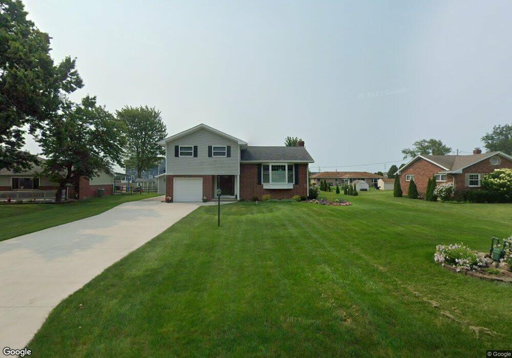
5731 Taylor St Walbridge, OH 43465
Walbridge AreaEstimated Value: $231,955 - $271,000
4
Beds
2
Baths
1,451
Sq Ft
$170/Sq Ft
Est. Value
About This Home
This home is located at 5731 Taylor St, Walbridge, OH 43465 and is currently estimated at $247,239, approximately $170 per square foot. 5731 Taylor St is a home located in Wood County with nearby schools including Lake Elementary School, Lake Middle School, and Lake High School.
Create a Home Valuation Report for This Property
The Home Valuation Report is an in-depth analysis detailing your home's value as well as a comparison with similar homes in the area
Mortgage History
We collect this data history from publicly available records. To have your information removed, we recommend requesting removal directly through your county’s website.
| Date | Status | Borrower | Loan Amount |
|---|---|---|---|
| Previous Owner | $94,000 | ||
| Previous Owner | $100,400 |
Source: Public Records
Tax History
We collect this data history from publicly available records. To have your information removed, we recommend requesting removal directly through your county’s website.
| Year | Tax Paid | Tax Assessment Tax Assessment Total Assessment is a certain percentage of the fair market value that is determined by local assessors to be the total taxable value of land and additions on the property. | Land | Improvement |
|---|---|---|---|---|
| 2025 | $3,288 | $54,845 | $10,500 | $44,345 |
| 2024 | $3,318 | $54,845 | $10,500 | $44,345 |
| 2023 | $3,318 | $54,850 | $10,500 | $44,350 |
| 2021 | $3,431 | $47,430 | $10,150 | $37,280 |
| 2020 | $3,352 | $47,430 | $10,150 | $37,280 |
| 2019 | $3,168 | $42,000 | $10,150 | $31,850 |
| 2018 | $3,186 | $42,000 | $10,150 | $31,850 |
| 2017 | $3,179 | $42,000 | $10,150 | $31,850 |
| 2016 | $3,059 | $40,040 | $10,150 | $29,890 |
| 2015 | $3,059 | $40,040 | $10,150 | $29,890 |
| 2014 | $3,216 | $40,040 | $10,150 | $29,890 |
| 2013 | $3,355 | $40,040 | $10,150 | $29,890 |
Source: Public Records
Map
Nearby Homes
- 5846 Cherokee Ave
- 6570 Alexander Dr
- 28180 Oregon Rd Unit 710
- 27696 Oregon Rd Unit 120
- 27696 Oregon Rd Unit 216
- 27484 Oregon Rd Unit 144
- 27484 Oregon Rd Unit 105
- 27484 Oregon Rd Unit 164
- 27484 Oregon Rd Unit 25
- 27484 Oregon Rd Unit 114
- 0 Oregon Rd Unit 10003432
- 7335 Ayers Rd
- 7386 Lunitas Ln Unit 388
- 28574 Lemoyne Rd
- 29658 Tracy Rd
- 5225 Hanley Rd
- 26021 Luckey Rd
- 7155 E Lake Ct
- 7187 E Lake Ct
- 117 Tyler Dr
- 5715 Taylor St
- 5743 Taylor St
- 5736 Neill Ave
- 5722 Neill Ave
- 5746 Neill Ave
- 5755 Taylor St
- 5714 Taylor St
- 5704 Taylor St
- 5746 Taylor St
- 5749 Neill Ave
- 5758 Taylor St
- 5801 Taylor St
- 5731 Neill Ave
- 5733 Moline Martin Rd
- 5713 Neill Ave
- 5731 Moline Martin Rd
- 5743 Neill Ave
- 5745 Moline Martin Rd
- 5806 Neill Ave
- 0 Moline Martin Rd
Your Personal Tour Guide
Ask me questions while you tour the home.