Estimated Value: $142,000 - $168,570
Studio
--
Bath
2,281
Sq Ft
$67/Sq Ft
Est. Value
About This Home
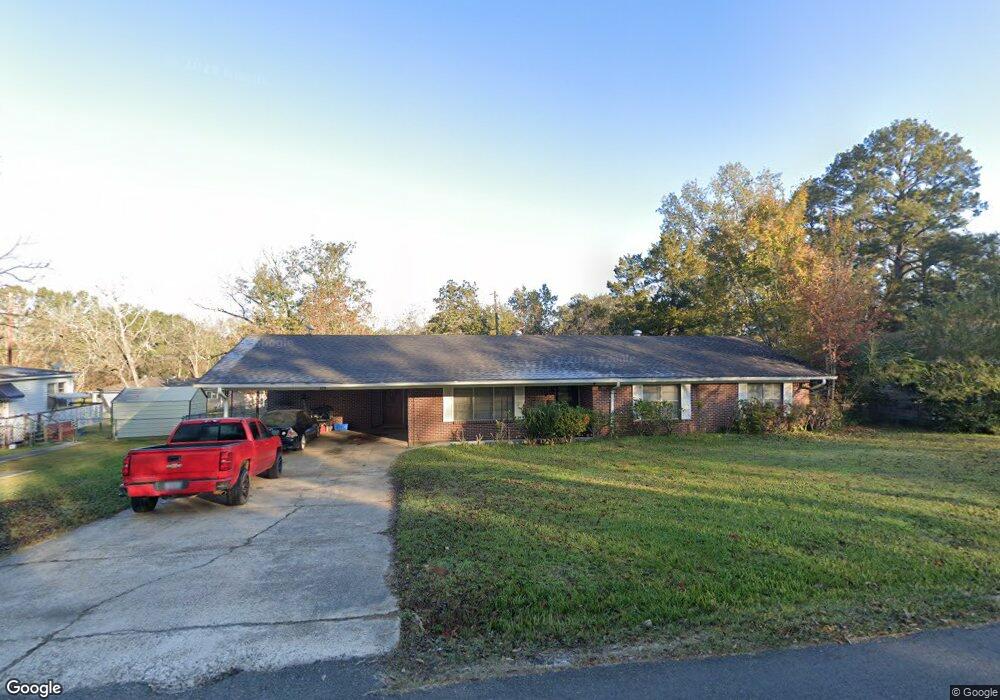
This home is located at 575 Trace St, Many, LA 71449 and is currently estimated at $152,393, approximately $66 per square foot. 575 Trace St is a home located in Sabine Parish with nearby schools including Many Junior High School and Many High School.
Ownership History
Date
Name
Owned For
Owner Type
Purchase Details
Closed on
Dec 16, 2020
Sold by
Kade Chamberlin Daniel and Salter Tabitha
Bought by
Notary Public
Current Estimated Value
Purchase Details
Closed on
Apr 2, 2018
Sold by
Hayes Steven L and Hayes-Lites Elizabeth A
Bought by
Rdg Rentals Llc
Purchase Details
Closed on
Dec 17, 2010
Sold by
Dodson James L and Dodson Nora Self
Bought by
Lewis Billy J
Purchase Details
Closed on
Aug 6, 2010
Sold by
Walker Jerry
Bought by
Bilyeu John P and Robinson Myrtis P
Purchase Details
Closed on
May 19, 2008
Sold by
Shaw Richard L
Bought by
Cooper Paul R
Purchase Details
Closed on
Apr 12, 2006
Sold by
Miler Mary Lee
Bought by
Dodson James L and Dodson Nora Self
Create a Home Valuation Report for This Property
The Home Valuation Report is an in-depth analysis detailing your home's value as well as a comparison with similar homes in the area
Home Values in the Area
Average Home Value in this Area
Purchase History
| Date | Buyer | Sale Price | Title Company |
|---|---|---|---|
| Notary Public | -- | None Listed On Document | |
| Rdg Rentals Llc | $100,000 | -- | |
| Lewis Billy J | $35,000 | None Available | |
| Bilyeu John P | $15,000 | None Available | |
| Cooper Paul R | $512 | None Available | |
| Dodson James L | $10,000 | None Available |
Source: Public Records
Tax History
| Year | Tax Paid | Tax Assessment Tax Assessment Total Assessment is a certain percentage of the fair market value that is determined by local assessors to be the total taxable value of land and additions on the property. | Land | Improvement |
|---|---|---|---|---|
| 2025 | $1,502 | $16,440 | $740 | $15,700 |
| 2024 | $1,346 | $16,440 | $740 | $15,700 |
| 2023 | $837 | $10,318 | $555 | $9,763 |
| 2022 | $920 | $10,318 | $555 | $9,763 |
| 2021 | $985 | $10,318 | $555 | $9,763 |
| 2020 | $1,066 | $10,318 | $555 | $9,763 |
| 2019 | $1,033 | $10,318 | $555 | $9,763 |
| 2018 | $758 | $7,190 | $630 | $6,560 |
| 2017 | $755 | $7,190 | $630 | $6,560 |
| 2016 | $752 | $7,190 | $630 | $6,560 |
| 2015 | $41 | $7,190 | $630 | $6,560 |
| 2014 | $41 | $7,190 | $630 | $6,560 |
Source: Public Records
Map
Nearby Homes
- 825 Shreveport Hwy
- 825 Shreveport Hwy Unit 8 & 9 Blk 14
- 765 N Capitol St
- 850 Hill St
- 0 Chasin Fin Dr Unit 6
- 0 Chasin Fin Dr Unit 5
- 0 Chasin Fin Dr Unit 4
- 0 Commercial Park Dr Unit 10931381
- 00 Chasin Fin Dr Unit 2
- 0 Chasin Fin Dr Unit 7
- 00 Chasin Fin Dr Unit 3
- 910 Ponder St Unit 27
- 295 Pine St
- 11460 Texas Hwy
- 000 Texas Hwy
- 0 Texas Hwy Unit 11330283
- 0 Texas Hwy Unit 11438353
- 0 Texas Hwy Unit 11438355
- 295 Highland Ave
- 120 Fisher Rd
Your Personal Tour Guide
Ask me questions while you tour the home.