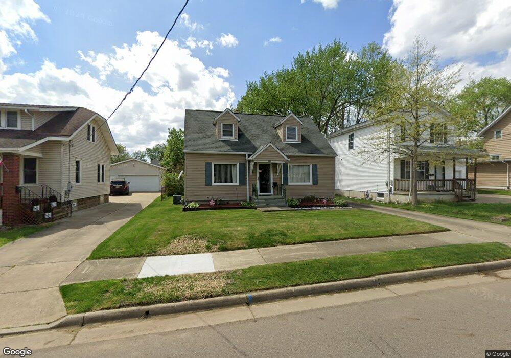
576 Cora Ave Akron, OH 44312
Ellet NeighborhoodEstimated Value: $149,000 - $196,000
2
Beds
1
Bath
923
Sq Ft
$184/Sq Ft
Est. Value
About This Home
This home is located at 576 Cora Ave, Akron, OH 44312 and is currently estimated at $169,392, approximately $183 per square foot. 576 Cora Ave is a home located in Summit County with nearby schools including Ellet High School, Summit Academy Akron Elementary School, and Hatton Community Learning Center.
Ownership History
Date
Name
Owned For
Owner Type
Purchase Details
Closed on
Jun 3, 2003
Sold by
Postek Michael L and Postek Lynnea K
Bought by
Hornsby John D and Hornsby Carletta
Current Estimated Value
Home Financials for this Owner
Home Financials are based on the most recent Mortgage that was taken out on this home.
Original Mortgage
$84,217
Outstanding Balance
$39,475
Interest Rate
7%
Mortgage Type
Purchase Money Mortgage
Estimated Equity
$129,917
Purchase Details
Closed on
Jul 20, 2000
Sold by
Grigsby Laurence W
Bought by
Postek Michael L
Create a Home Valuation Report for This Property
The Home Valuation Report is an in-depth analysis detailing your home's value as well as a comparison with similar homes in the area
Home Values in the Area
Average Home Value in this Area
Purchase History
| Date | Buyer | Sale Price | Title Company |
|---|---|---|---|
| Hornsby John D | $88,650 | Johnson & Parrish Title Agen | |
| Postek Michael L | $45,774 | -- |
Source: Public Records
Mortgage History
| Date | Status | Borrower | Loan Amount |
|---|---|---|---|
| Open | Hornsby John D | $84,217 |
Source: Public Records
Tax History
| Year | Tax Paid | Tax Assessment Tax Assessment Total Assessment is a certain percentage of the fair market value that is determined by local assessors to be the total taxable value of land and additions on the property. | Land | Improvement |
|---|---|---|---|---|
| 2024 | $2,426 | $44,104 | $9,734 | $34,370 |
| 2023 | $2,426 | $44,104 | $9,734 | $34,370 |
| 2022 | $2,168 | $30,706 | $6,668 | $24,038 |
| 2021 | $2,095 | $30,706 | $6,668 | $24,038 |
| 2020 | $2,063 | $30,710 | $6,670 | $24,040 |
| 2019 | $1,967 | $26,530 | $6,670 | $19,860 |
| 2018 | $1,941 | $26,530 | $6,670 | $19,860 |
| 2017 | $1,825 | $26,530 | $6,670 | $19,860 |
| 2016 | $1,826 | $24,460 | $6,670 | $17,790 |
| 2015 | $1,825 | $24,460 | $6,670 | $17,790 |
| 2014 | $1,810 | $24,460 | $6,670 | $17,790 |
| 2013 | $1,931 | $26,750 | $6,670 | $20,080 |
Source: Public Records
Map
Nearby Homes
- 601 Cora Ave
- 2566 & 2568 Albrecht Ave
- 412 Stevenson Ave
- 404 Wirth Ave
- 2522 Ogden Ave
- 864 Shadybrook Dr
- 805 Utica Ave
- 2805 Shelburn Ave
- 640 Plainfield Rd
- 2904 Pepper Hill Cir
- 189 Pocantico Ave
- 2323 Mingo Trail
- 479 Junior Ave
- 1010 Crestline Dr
- 0 Kreiner Ave
- 2226 Quayle Dr
- 410 Columbine Ave
- 2864 Burnside St
- 1054 Crestline Dr
- 448 Fritsch Ave
Your Personal Tour Guide
Ask me questions while you tour the home.