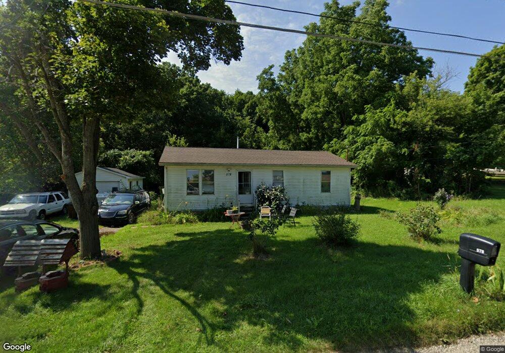
578 E Main St Springport, MI 49284
Estimated Value: $106,000 - $138,000
3
Beds
1
Bath
920
Sq Ft
$137/Sq Ft
Est. Value
About This Home
This home is located at 578 E Main St, Springport, MI 49284 and is currently estimated at $125,915, approximately $136 per square foot. 578 E Main St is a home located in Jackson County with nearby schools including Springport Elementary School, Springport Middle School, and Springport High School.
Ownership History
Date
Name
Owned For
Owner Type
Purchase Details
Closed on
Oct 11, 2013
Sold by
Ghere John R
Bought by
Pennell Kathleen M
Current Estimated Value
Purchase Details
Closed on
Sep 29, 2005
Sold by
Bieski Gary W
Bought by
Pennell Kathleen M
Home Financials for this Owner
Home Financials are based on the most recent Mortgage that was taken out on this home.
Original Mortgage
$75,525
Interest Rate
9.2%
Mortgage Type
Fannie Mae Freddie Mac
Create a Home Valuation Report for This Property
The Home Valuation Report is an in-depth analysis detailing your home's value as well as a comparison with similar homes in the area
Purchase History
| Date | Buyer | Sale Price | Title Company |
|---|---|---|---|
| Pennell Kathleen M | $49,500 | Midstate Title Agency Of Sou | |
| Pennell Kathleen M | $79,500 | Mst |
Source: Public Records
Mortgage History
| Date | Status | Borrower | Loan Amount |
|---|---|---|---|
| Previous Owner | Pennell Kathleen M | $75,525 |
Source: Public Records
Tax History
| Year | Tax Paid | Tax Assessment Tax Assessment Total Assessment is a certain percentage of the fair market value that is determined by local assessors to be the total taxable value of land and additions on the property. | Land | Improvement |
|---|---|---|---|---|
| 2025 | $1,015 | $47,200 | $0 | $0 |
| 2024 | $6 | $51,200 | $0 | $0 |
| 2023 | $606 | $43,500 | $0 | $0 |
| 2022 | $1,206 | $30,200 | $0 | $0 |
| 2021 | $912 | $28,900 | $0 | $0 |
| 2020 | $274 | $28,600 | $0 | $0 |
| 2019 | $1,272 | $25,300 | $0 | $0 |
| 2018 | $858 | $23,400 | $0 | $0 |
| 2017 | $814 | $23,200 | $0 | $0 |
| 2016 | $256 | $22,800 | $22,800 | $0 |
| 2015 | -- | $25,200 | $25,200 | $0 |
| 2014 | -- | $27,700 | $27,700 | $0 |
| 2013 | -- | $27,700 | $27,700 | $0 |
Source: Public Records
Map
Nearby Homes
- 598 E Main St
- 330 Grand St
- 16711 Stark Rd
- 13025 Pope Church Rd
- 29510 S Dr N
- 7295 N Gibbs Rd
- 12261 Pope Church Rd
- 9761 Brown Rd
- 12441 Town Rd
- 9733 Blue Heron
- 19822 27 1 2 Mile Rd
- 15394 Devereaux Rd
- 28660 E Baseline Hwy
- 6950 Brown Rd
- 6947 Brown Rd
- 9673 Spartan Ln
- 8840 Houston Rd
- 26854 Q-Drive N
- 0 Springport Rd
- 26493 Anderson Rd
- 586 E Main St
- 570 E Main St
- 590 E Main St
- 566 E Main St
- 564 E Main St
- 560 E Main St
- 257 Green St
- 556 E Main St
- 556 E Main St
- 15202 Eaton Rapids Rd
- 550 E Main St
- 260 Bay Port Cir Unit 21
- 252 Bay Port Cir Unit 19
- 239 Bay Port Cir Unit 66
- 263 Bay Port Cir Unit 60
- 294 Bay Port Cir Unit 56
- 268 Bay Port Cir Unit 23
- 280 Bay Port Cir Unit 26
- 216 Bayport Cir Unit 10
- 247 Bayport Cir Unit 64
Your Personal Tour Guide
Ask me questions while you tour the home.