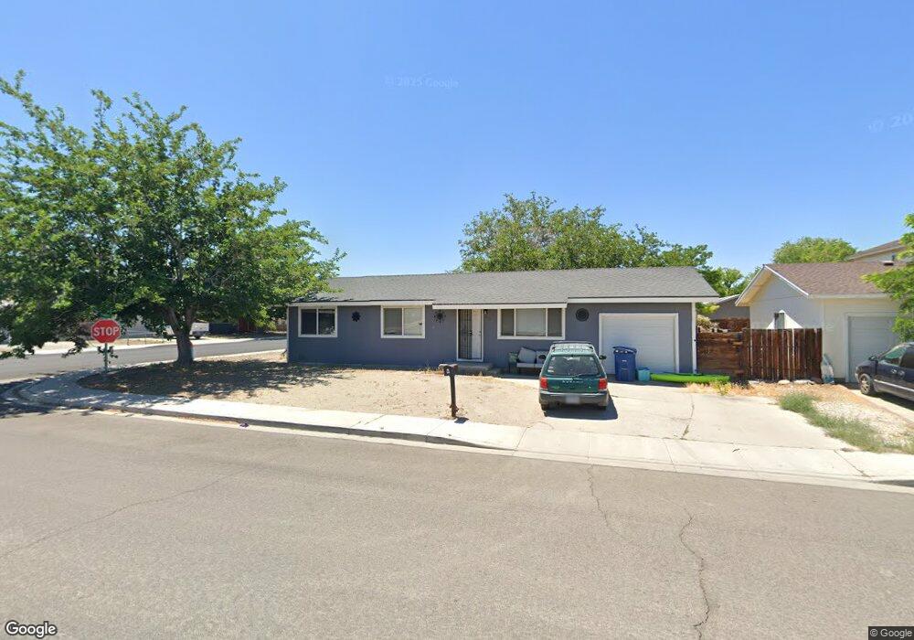
580 Anthony Ln Fallon, NV 89406
Estimated Value: $275,759 - $284,000
3
Beds
2
Baths
1,008
Sq Ft
$278/Sq Ft
Est. Value
About This Home
This home is located at 580 Anthony Ln, Fallon, NV 89406 and is currently estimated at $279,940, approximately $277 per square foot. 580 Anthony Ln is a home located in Churchill County with nearby schools including Lahontan Elementary School, E.C. Best Elementary School, and Numa Elementary School.
Ownership History
Date
Name
Owned For
Owner Type
Purchase Details
Closed on
Apr 15, 2021
Sold by
Bird Brandon and Bird Lisa
Bought by
Coatney Ciera and Coatney Ellen
Current Estimated Value
Home Financials for this Owner
Home Financials are based on the most recent Mortgage that was taken out on this home.
Original Mortgage
$208,160
Outstanding Balance
$188,094
Interest Rate
3.05%
Mortgage Type
FHA
Estimated Equity
$91,846
Purchase Details
Closed on
Feb 7, 2005
Sold by
York Anita A
Bought by
Bird Brandon and Bird Lisa
Home Financials for this Owner
Home Financials are based on the most recent Mortgage that was taken out on this home.
Original Mortgage
$84,000
Interest Rate
5.81%
Create a Home Valuation Report for This Property
The Home Valuation Report is an in-depth analysis detailing your home's value as well as a comparison with similar homes in the area
Home Values in the Area
Average Home Value in this Area
Purchase History
| Date | Buyer | Sale Price | Title Company |
|---|---|---|---|
| Coatney Ciera | $212,000 | Western Nevada Title Co | |
| Bird Brandon | $105,500 | Western Nevada Title Company |
Source: Public Records
Mortgage History
| Date | Status | Borrower | Loan Amount |
|---|---|---|---|
| Open | Coatney Ciera | $208,160 | |
| Previous Owner | Bird Brandon | $84,000 |
Source: Public Records
Tax History
| Year | Tax Paid | Tax Assessment Tax Assessment Total Assessment is a certain percentage of the fair market value that is determined by local assessors to be the total taxable value of land and additions on the property. | Land | Improvement |
|---|---|---|---|---|
| 2025 | $915 | $28,750 | $13,650 | $15,100 |
| 2024 | $915 | $27,873 | $12,950 | $14,923 |
| 2023 | $915 | $25,896 | $12,250 | $13,646 |
| 2022 | $751 | $20,291 | $8,050 | $12,241 |
| 2021 | $750 | $20,281 | $8,050 | $12,231 |
| 2020 | $771 | $20,903 | $8,050 | $12,853 |
| 2019 | $767 | $20,928 | $8,050 | $12,878 |
| 2018 | $744 | $20,948 | $8,050 | $12,898 |
| 2017 | $714 | $19,717 | $6,475 | $13,242 |
| 2016 | $696 | $19,149 | $6,475 | $12,674 |
| 2015 | $683 | $17,944 | $6,475 | $11,469 |
| 2014 | $662 | $17,703 | $7,000 | $10,703 |
Source: Public Records
Map
Nearby Homes
- 521 Whitaker Ln
- 650 Cora Way
- 861 W Center St
- 841 W Center St
- 1009 Deena Way
- 745 W Center St
- 360 & 360 1/2 W Virginia St
- 65 S Bailey St
- 250 S Taylor St
- 1291 S Taylor St
- 1040 Tiffany Dr
- 2210 Christie Cir
- 1091 Tiffany Dr
- 1044 Allen Rd
- 345 Lincoln St
- 1.55 Acres on S Maine St
- 635 Churchill St
- 12017 Power Line Rd
- 654 Douglas St
- 009-291-74 00929174
- 560 Anthony Ln
- 581 Whitaker Ln
- 561 Whitaker Ln
- 1041 Sunset Dr
- 1000 Sunset Dr
- 1021 Sunset Dr
- 541 Whitaker Ln
- 561 Anthony Ln
- 1081 Sunset Dr
- 991 Sunset Dr
- 520 Anthony Ln
- 541 Anthony Ln
- 1040 Liberty Ave
- 1060 Liberty Ave Unit 3A
- 1060 Liberty Ave Unit 1
- 981 Sunset Dr
- 521 Anthony Ln
- 1020 Liberty Ave
- 510 Anthony Ln
- 980 Sunset Dr
Your Personal Tour Guide
Ask me questions while you tour the home.