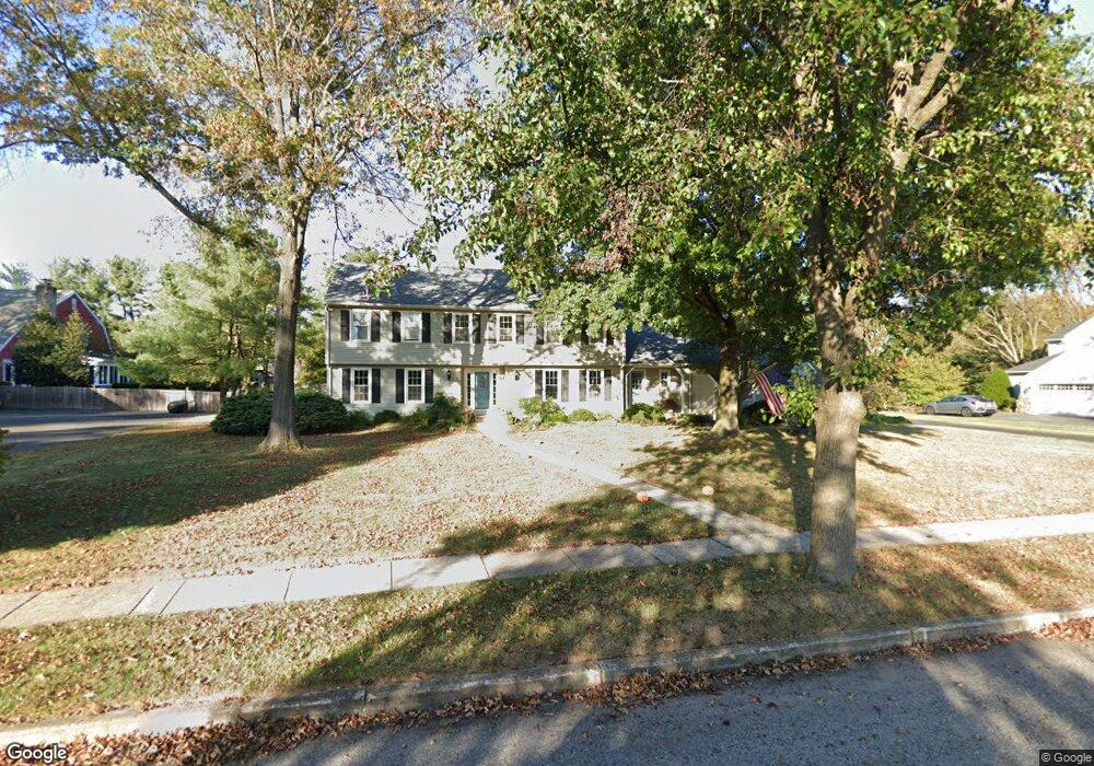
581 Sentinel Rd Moorestown, NJ 08057
Estimated Value: $925,866 - $1,155,000
Studio
--
Bath
3,137
Sq Ft
$333/Sq Ft
Est. Value
About This Home
This home is located at 581 Sentinel Rd, Moorestown, NJ 08057 and is currently estimated at $1,045,622, approximately $333 per square foot. 581 Sentinel Rd is a home located in Burlington County with nearby schools including George C. Baker Elementary School, Moorestown Upper Elementary School, and William Allen Middle School.
Ownership History
Date
Name
Owned For
Owner Type
Purchase Details
Closed on
Oct 30, 1997
Sold by
Hess Nancian R
Bought by
Donahue Lawrence and Donahue Jean E
Current Estimated Value
Home Financials for this Owner
Home Financials are based on the most recent Mortgage that was taken out on this home.
Original Mortgage
$190,000
Outstanding Balance
$31,182
Interest Rate
7.28%
Estimated Equity
$1,014,440
Create a Home Valuation Report for This Property
The Home Valuation Report is an in-depth analysis detailing your home's value as well as a comparison with similar homes in the area
Home Values in the Area
Average Home Value in this Area
Purchase History
| Date | Buyer | Sale Price | Title Company |
|---|---|---|---|
| Donahue Lawrence | $332,000 | -- |
Source: Public Records
Mortgage History
| Date | Status | Borrower | Loan Amount |
|---|---|---|---|
| Open | Donahue Lawrence | $190,000 |
Source: Public Records
Tax History
| Year | Tax Paid | Tax Assessment Tax Assessment Total Assessment is a certain percentage of the fair market value that is determined by local assessors to be the total taxable value of land and additions on the property. | Land | Improvement |
|---|---|---|---|---|
| 2025 | $14,897 | $525,100 | $231,000 | $294,100 |
| 2024 | $14,446 | $525,100 | $231,000 | $294,100 |
| 2023 | $14,446 | $525,100 | $231,000 | $294,100 |
| 2022 | $14,298 | $525,100 | $231,000 | $294,100 |
| 2021 | $14,109 | $525,100 | $231,000 | $294,100 |
| 2020 | $14,020 | $525,100 | $231,000 | $294,100 |
| 2019 | $13,773 | $525,100 | $231,000 | $294,100 |
| 2018 | $13,401 | $525,100 | $231,000 | $294,100 |
| 2017 | $13,516 | $525,100 | $231,000 | $294,100 |
| 2016 | $13,469 | $525,100 | $231,000 | $294,100 |
| 2015 | $13,306 | $525,100 | $231,000 | $294,100 |
| 2014 | $12,634 | $525,100 | $231,000 | $294,100 |
Source: Public Records
Map
Nearby Homes
- 807 Westfield Rd
- 628 Windsock Way
- 106 Ashley Ct
- 744 Signal Light Rd
- 745 N Stanwick Rd
- 697 Garwood Rd
- 863 Golf View Rd
- 740 Garwood Rd
- 16 Windermere Dr
- 408 N Stanwick Rd
- 109 Congressional Ct
- 101 Congressional Ct
- 115 Congressional Ct
- 315 Linden St
- 4327 Bridgeboro Rd
- 429 E 2nd St
- 396 E Linden St
- 635 E Main St Unit 7
- 119 Linda Ave
- 751 Garwood Rd
- 579 Sentinel Rd
- 583 Sentinel Rd
- 585 Sentinel Rd
- 582 Sentinel Rd
- 580 Sentinel Rd
- 577 Sentinel Rd
- 799 Westfield Rd
- 584 Sentinel Rd
- 783 Westfield Rd
- 578 Sentinel Rd
- 587 Sentinel Rd
- 4 Eaglebrook Ct
- 575 Sentinel Rd
- 588 Sentinel Rd
- 576 Sentinel Rd
- 5 Eaglebrook Ct
- 589 Sentinel Rd
- 3 Eaglebrook Ct
- 574 Sentinel Rd
- 573 Sentinel Rd
Your Personal Tour Guide
Ask me questions while you tour the home.