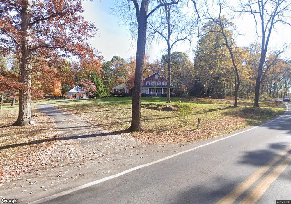
582 Daniel Rd Shenandoah Junction, WV 25442
Estimated Value: $516,000 - $721,000
4
Beds
4
Baths
2,920
Sq Ft
$214/Sq Ft
Est. Value
About This Home
This home is located at 582 Daniel Rd, Shenandoah Junction, WV 25442 and is currently estimated at $623,794, approximately $213 per square foot. 582 Daniel Rd is a home located in Jefferson County with nearby schools including T.A. Lowery Elementary School, Wildwood Middle School, and Jefferson High School.
Ownership History
Date
Name
Owned For
Owner Type
Purchase Details
Closed on
Aug 28, 2023
Sold by
Marsceau Van E and Marsceau Janet P
Bought by
Marsceau Family Trust and Marsceau
Current Estimated Value
Purchase Details
Closed on
Jul 22, 2022
Sold by
Cory Steele
Bought by
Marsceau Van
Home Financials for this Owner
Home Financials are based on the most recent Mortgage that was taken out on this home.
Original Mortgage
$100,000
Interest Rate
5.78%
Mortgage Type
Credit Line Revolving
Create a Home Valuation Report for This Property
The Home Valuation Report is an in-depth analysis detailing your home's value as well as a comparison with similar homes in the area
Home Values in the Area
Average Home Value in this Area
Purchase History
| Date | Buyer | Sale Price | Title Company |
|---|---|---|---|
| Marsceau Family Trust | -- | None Listed On Document | |
| Marsceau Family Trust | -- | None Listed On Document | |
| Marsceau Van | $1,323 | Pill & Pill Pllc |
Source: Public Records
Mortgage History
| Date | Status | Borrower | Loan Amount |
|---|---|---|---|
| Previous Owner | Marsceau Van | $100,000 |
Source: Public Records
Tax History
| Year | Tax Paid | Tax Assessment Tax Assessment Total Assessment is a certain percentage of the fair market value that is determined by local assessors to be the total taxable value of land and additions on the property. | Land | Improvement |
|---|---|---|---|---|
| 2025 | $4,050 | $348,500 | $84,700 | $263,800 |
| 2024 | $3,712 | $317,100 | $84,700 | $232,400 |
| 2023 | $3,704 | $317,100 | $84,700 | $232,400 |
| 2022 | $3,139 | $263,400 | $79,300 | $184,100 |
| 2021 | $2,876 | $236,800 | $73,800 | $163,000 |
| 2020 | $2,524 | $221,800 | $71,000 | $150,800 |
| 2019 | $2,541 | $219,100 | $68,300 | $150,800 |
| 2018 | $2,499 | $212,700 | $65,600 | $147,100 |
| 2017 | $2,434 | $207,200 | $60,100 | $147,100 |
| 2016 | $2,533 | $216,200 | $67,500 | $148,700 |
| 2015 | $2,438 | $207,000 | $67,500 | $139,500 |
| 2014 | $2,125 | $180,800 | $51,900 | $128,900 |
Source: Public Records
Map
Nearby Homes
- 547 Atkinson St
- 414 Buckeye Dr
- 562 Atkinson St
- 574 Atkinson St
- 576 Thumper Dr
- 0 Currie Road Rt 9 and Mildred St Unit WVJF2016654
- 351 Thumper Dr
- 35 Grant Rd
- 33 National St
- 316 Presidents Pointe Ave
- 300 Presidents Pointe Ave Unit [609]
- 304 Presidents Pointe Ave Unit [610]
- 312 Presidents Pointe Ave
- 308 Presidents Pointe Ave
- 300 Presidents Pointe Ave
- 304 Presidents Pointe Ave
- 308 Presidents Pointe Ave Unit [611]
- 316 Presidents Pointe Ave Unit [613]
- 312 Presidents Pointe Ave Unit [612]
- 135 Presidents Pointe Ave
- 623 Daniel Rd
- 948 Daniel Rd
- 0 Daniel Rd Unit 1000222507
- 185 Johnny Way
- 57 Zoar Ln
- 56 Zoar Ln
- 3309 Flowing Springs Rd
- 3195 Flowing Springs Rd
- 3305 Flowing Springs Rd
- 2833 Flowing Springs Rd
- 2757 Flowing Springs Rd
- 313 Atkinson St
- 176 Atkinson St Unit 36203397
- 241 Atkinson St
- 3368 Flowing Springs Rd
- 265 Atkinson St
- 265 Atkinson St
- 261 Media Farm Ln
- 402 Atkinson St
- 27 Wintergreen Way
Your Personal Tour Guide
Ask me questions while you tour the home.