
Landlord's Agent in 2026
Lynn Griese
CB Realty (Union Heights)
(818) 468-8323
69 Total Sales

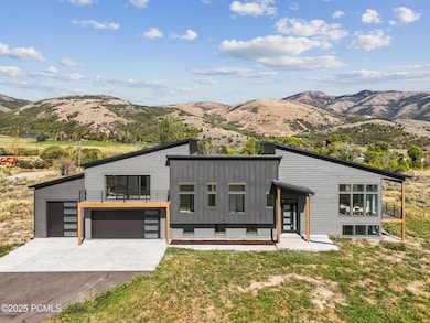
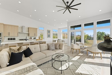
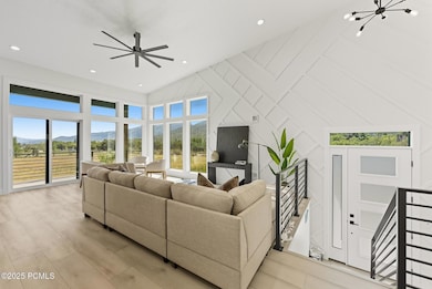
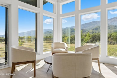
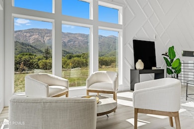
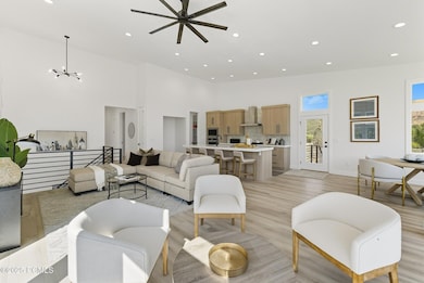
Enjoy breathtaking, unobstructed views of the Wasatch Mountains from this beautifully remodeled Eden retreat-where Nordic
Valley Ski Resort is visible right from your window, and Powder Mountain and Snowbasin are just minutes away. *** Fully updated in 2024, this mountain-modern home offers 6 spacious bedrooms, 4.5 bathrooms, and a 3-car garage-perfect for comfortable living and entertaining. Vaulted ceilings and expansive windows fill the home with natural light and showcase stunning 360 views. *** The primary suite features a spa-like ensuite, walk-in closet with laundry hookups, and a private balcony for peaceful mornings or starlit evenings. Downstairs, a second kitchen and ensuite bedroom provide flexible options for guests or a Mother-In-Law suite. 6+ month lease is ideal but landlord will consider other terms.
Last Agent to Rent the Property
CB Realty (Union Heights) License #9604125-SA00 Listed on: 10/06/2025
Last Renter's Agent
Non Agent
Non Member
We collect this data history from publicly available records. To have your information removed, we recommend requesting removal directly through your county’s website.
| Date | Event | Price | List to Sale | Price per Sq Ft |
|---|---|---|---|---|
| 01/16/2026 01/16/26 | Rented | $5,200 | -1.0% | -- |
| 01/16/2026 01/16/26 | Under Contract | -- | -- | -- |
| 12/08/2025 12/08/25 | Price Changed | $5,250 | -4.5% | $1 / Sq Ft |
| 10/06/2025 10/06/25 | For Rent | $5,500 | -- | -- |
We collect this data history from publicly available records. To have your information removed, we recommend requesting removal directly through your county’s website.
| Year | Tax Paid | Tax Assessment Tax Assessment Total Assessment is a certain percentage of the fair market value that is determined by local assessors to be the total taxable value of land and additions on the property. | Land | Improvement |
|---|---|---|---|---|
| 2024 | $5,662 | $578,000 | $359,624 | $218,376 |
| 2023 | $2,863 | $522,530 | $359,090 | $163,440 |
| 2022 | $2,707 | $502,562 | $310,003 | $192,559 |
| 2021 | $1,892 | $322,943 | $175,035 | $147,908 |
| 2020 | $1,888 | $297,000 | $152,500 | $144,500 |
| 2019 | $1,787 | $267,943 | $142,518 | $125,425 |
| 2018 | $1,854 | $266,662 | $127,500 | $139,162 |
| 2017 | $1,629 | $230,539 | $112,500 | $118,039 |
| 2016 | $1,658 | $130,855 | $59,750 | $71,105 |
| 2015 | $1,676 | $130,855 | $59,750 | $71,105 |
| 2014 | $1,433 | $109,000 | $57,000 | $52,000 |
Landlord's Agent in 2026
Lynn Griese
CB Realty (Union Heights)
(818) 468-8323
69 Total Sales
Landlord's Co-Listing Agent in 2026
Meredith Reed
Coldwell Banker Realty (Park City-NewPark)
(435) 571-1090
29 Total Sales
N
Tenant's Agent in 2026
Non Agent
Non Member
Source: Park City Board of REALTORS®
MLS Number: 12504372
APN: 22-004-0046
Disclaimer: Certain information contained herein is derived from information provided by parties other than Homes.com. All information provided is deemed reliable, but is not guaranteed to be accurate and should be independently verified.
![]() This information is provided exclusively for consumers’ personal, non-commercial use, and it may not be used for any purpose other than to identify prospective properties consumers may be interested in purchasing. This data is deemed reliable but is not guaranteed accurate by the MLS.
This information is provided exclusively for consumers’ personal, non-commercial use, and it may not be used for any purpose other than to identify prospective properties consumers may be interested in purchasing. This data is deemed reliable but is not guaranteed accurate by the MLS.
The multiple listing information is provided by Park City Board of REALTORS® from a copyrighted compilation of listings. The compilation of listings and each individual listing are © 2026 Park City Board of REALTORS®, All Rights Reserved. Access to the multiple listing information through this website is made available by Ten-X as a member of the Park City Board of REALTORS® multiple listing service.
Ask me questions while you tour the home.