Estimated Value: $486,585 - $660,000
4
Beds
3
Baths
2,367
Sq Ft
$234/Sq Ft
Est. Value
About This Home
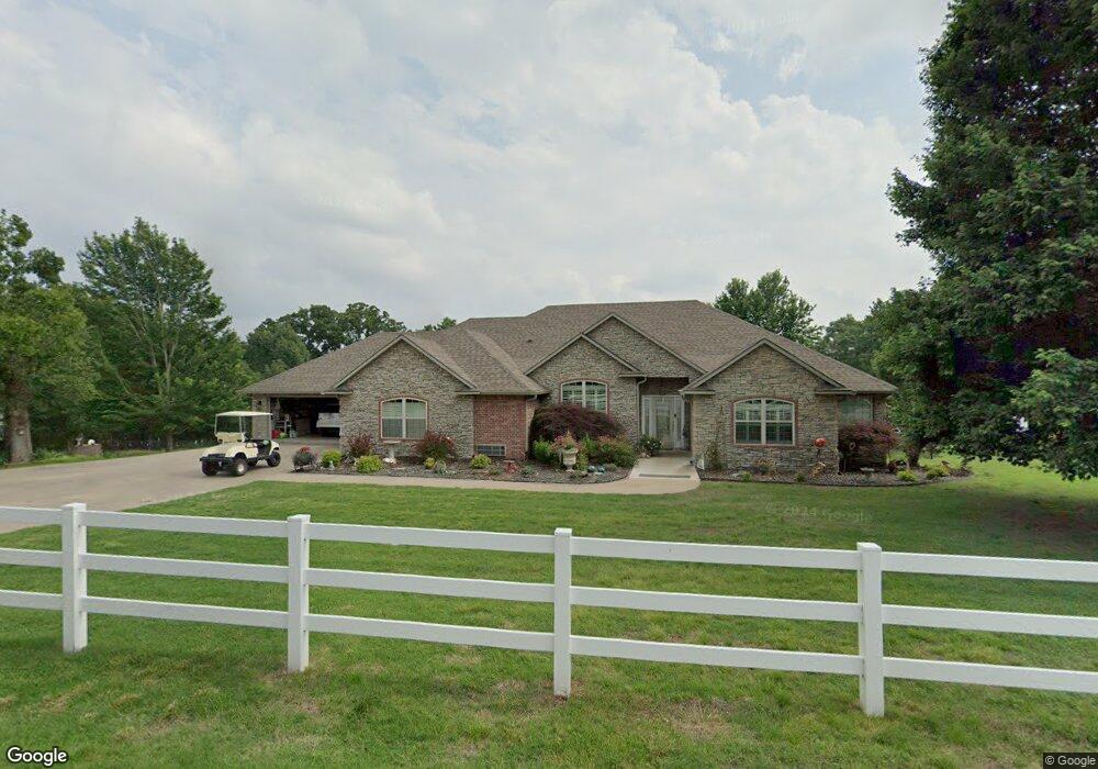
This home is located at 59031 E 301 Rd, Grove, OK 74344 and is currently estimated at $554,396, approximately $234 per square foot. 59031 E 301 Rd is a home located in Delaware County with nearby schools including Grove Lower Elementary School, Grove Upper Elementary School, and Grove Middle School.
Ownership History
Date
Name
Owned For
Owner Type
Purchase Details
Closed on
Jun 30, 2020
Sold by
Gardner Linda and Gardner Family Revocable Livin
Bought by
Harp John Thomas and Delharp Kari Del
Current Estimated Value
Purchase Details
Closed on
Jul 9, 2013
Sold by
Stowell Marcia K and Stowell Phillip C
Bought by
Gardner Ronald and Gardner Linda L
Purchase Details
Closed on
Apr 3, 1999
Sold by
Towry Gayle and Norma Jean
Create a Home Valuation Report for This Property
The Home Valuation Report is an in-depth analysis detailing your home's value as well as a comparison with similar homes in the area
Home Values in the Area
Average Home Value in this Area
Purchase History
| Date | Buyer | Sale Price | Title Company |
|---|---|---|---|
| Harp John Thomas | $341,000 | None Available | |
| Gardner Ronald | $295,500 | Grand River Abstract & Tit | |
| -- | $22,000 | -- |
Source: Public Records
Tax History
| Year | Tax Paid | Tax Assessment Tax Assessment Total Assessment is a certain percentage of the fair market value that is determined by local assessors to be the total taxable value of land and additions on the property. | Land | Improvement |
|---|---|---|---|---|
| 2025 | $3,293 | $41,676 | $3,194 | $38,482 |
| 2024 | $3,195 | $40,462 | $3,101 | $37,361 |
| 2023 | $3,195 | $39,284 | $2,990 | $36,294 |
| 2022 | $3,197 | $39,284 | $2,990 | $36,294 |
| 2021 | $3,184 | $39,215 | $2,990 | $36,225 |
| 2020 | $0 | $30,896 | $2,990 | $27,906 |
| 2019 | $0 | $30,062 | $2,990 | $27,072 |
| 2018 | $0 | $30,102 | $2,990 | $27,112 |
| 2017 | $0 | $29,777 | $2,990 | $26,787 |
| 2016 | $0 | $29,311 | $2,875 | $26,436 |
| 2015 | -- | $29,311 | $2,875 | $26,436 |
| 2014 | $2,456 | $29,311 | $2,875 | $26,436 |
Source: Public Records
Map
Nearby Homes
- TBD S 592 Lot 27 Place
- TBD S 592 Lot 26
- TBD S 592 Lot 25 Place
- TBD S 592 Place
- 59421 E 301 Rd
- 29900 S 592 Place
- 59488 E 301 Rd
- 58593 E 296 Place
- 58551 E 296 Place
- 29524 S 585 Ct
- Lot 1 & 2 S 585 Ct
- Lot 1 S 585 Ct
- Lot 2 S 585 Ct
- 29573 S 585 Ct
- 29501 S 585 Ct
- 6026 Lake Breeze Rd
- 4926 Lost Cove Rd
- 1019 Village Dr
- 4971 Lighthouse Springs Dr
- 4967 Lighthouse Springs Dr
Your Personal Tour Guide
Ask me questions while you tour the home.