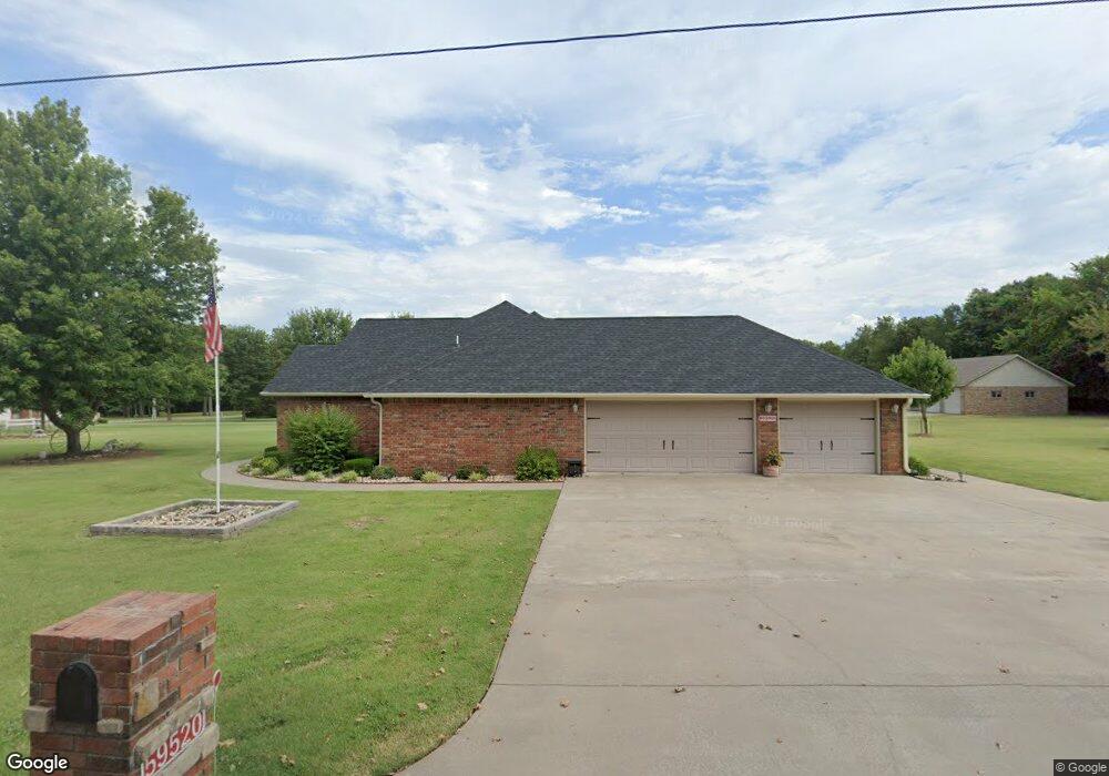
59520 E 290 Rd Grove, OK 74344
Grove AreaEstimated Value: $313,000 - $507,000
About This Home
This home is located at 59520 E 290 Rd, Grove, OK 74344 and is currently estimated at $415,273, approximately $225 per square foot. 59520 E 290 Rd is a home located in Delaware County with nearby schools including Grove Lower Elementary School, Grove Upper Elementary School, and Grove Middle School.
Ownership History
We collect this data history from publicly available records. To have your information removed, we recommend requesting removal directly through your county’s website.
Purchase Details
Purchase Details
Purchase Details
Home Values in the Area
Average Home Value in this Area
Purchase History
We collect this data history from publicly available records. To have your information removed, we recommend requesting removal directly through your county’s website.
| Date | Buyer | Sale Price | Title Company |
|---|---|---|---|
| $24,984 | -- | ||
| $215,000 | -- | ||
| $206,000 | -- |
Tax History
We collect this data history from publicly available records. To have your information removed, we recommend requesting removal directly through your county’s website.
| Year | Tax Paid | Tax Assessment Tax Assessment Total Assessment is a certain percentage of the fair market value that is determined by local assessors to be the total taxable value of land and additions on the property. | Land | Improvement |
|---|---|---|---|---|
| 2025 | $2,527 | $31,212 | $2,247 | $28,965 |
| 2024 | $2,407 | $29,726 | $2,140 | $27,586 |
| 2023 | $2,407 | $28,310 | $2,037 | $26,273 |
| 2022 | $2,168 | $27,771 | $2,013 | $25,758 |
| 2021 | $2,097 | $26,962 | $2,013 | $24,949 |
| 2020 | $2,068 | $25,415 | $2,013 | $23,402 |
| 2019 | $2,092 | $25,598 | $2,013 | $23,585 |
| 2018 | $2,024 | $24,852 | $2,013 | $22,839 |
| 2017 | $1,996 | $24,915 | $2,013 | $22,902 |
| 2016 | $1,935 | $23,737 | $2,013 | $21,724 |
| 2015 | $1,963 | $23,737 | $1,323 | $22,414 |
| 2014 | $1,972 | $23,737 | $1,323 | $22,414 |
Map
- TBD S 595 Cir
- 59399 E 288 Ct
- 59382 E 288 Ct
- 59386 E 288 Ct
- 59396 E 288 Ct
- 28910 S 593 Rd
- 4926 Lost Cove Rd
- 4967 Lighthouse Springs Dr
- 1513 Carey Dr
- 4987 Lighthouse Springs Dr
- 4971 Lighthouse Springs Dr
- 4972 Lighthouse Springs Dr
- 4975 Lake Breeze Rd
- 5013 Lake Breeze Rd
- 209 Walnut Cir
- 5020 Lake Breeze Rd
- 707 Quail Run Rd
- 29900 S 592 Place
- 29921 S 592 Place
- 827 Chatsworth Dr
- 28842 S 595 Cir
- 28980 S 594 Ln
- 28960 S 594 Ln
- E E 290 Rd
- 59150 E 290 Rd
- 59160 E 290 Rd
- 28950 S 594 Ln
- 28961 S 594 Ln
- 28940 S 594 Ln
- 59341 E 289 Ct
- 59400 E 290 Rd
- 29068 S 595 Rd
- 0 S 594 Ln
- 0 E 290 Rd Unit 20-1016
- 0 E 290 Rd Unit 21-532
- 0 E 290 Rd Unit 1011359
- TBD Lot 8 S 595 Cir
- 59601 E 290 Rd
- 28920 S 594 Ln
- 28875 S 595 Cir
Ask me questions while you tour the home.