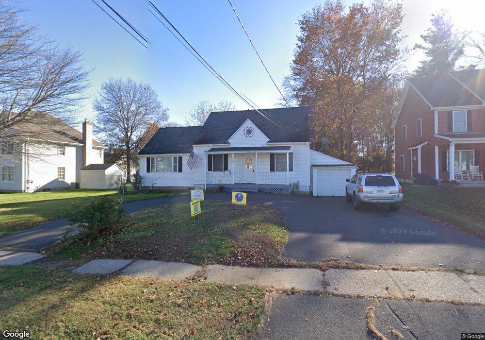
599 Nott St Wethersfield, CT 06109
Estimated Value: $437,000 - $532,000
5
Beds
2
Baths
2,530
Sq Ft
$189/Sq Ft
Est. Value
About This Home
This home is located at 599 Nott St, Wethersfield, CT 06109 and is currently estimated at $477,374, approximately $188 per square foot. 599 Nott St is a home located in Hartford County with nearby schools including Emerson-Williams School, Silas Deane Middle School, and Wethersfield High School.
Ownership History
Date
Name
Owned For
Owner Type
Purchase Details
Closed on
May 14, 2018
Sold by
Demay Mark and Demay Robin
Bought by
Mdrd Ft 2018
Current Estimated Value
Purchase Details
Closed on
Jul 25, 2005
Sold by
Collett Robert L and Hubbard Diane J
Bought by
Demay Mark
Home Financials for this Owner
Home Financials are based on the most recent Mortgage that was taken out on this home.
Original Mortgage
$244,000
Interest Rate
5.5%
Purchase Details
Closed on
Jul 26, 2004
Sold by
Daab Lisa A
Bought by
Hubbard Diane J and Collett Robert L
Home Financials for this Owner
Home Financials are based on the most recent Mortgage that was taken out on this home.
Original Mortgage
$207,900
Interest Rate
5.37%
Purchase Details
Closed on
Aug 5, 1999
Sold by
Casale Jeanette
Bought by
Daah Lisa A
Create a Home Valuation Report for This Property
The Home Valuation Report is an in-depth analysis detailing your home's value as well as a comparison with similar homes in the area
Home Values in the Area
Average Home Value in this Area
Purchase History
We collect this data history from publicly available records. To have your information removed, we recommend requesting removal directly through your county’s website.
| Date | Buyer | Sale Price | Title Company |
|---|---|---|---|
| Mdrd Ft 2018 | $250,000 | -- | |
| Demay Mark | $305,000 | -- | |
| Hubbard Diane J | $259,900 | -- | |
| Daah Lisa A | $89,900 | -- |
Source: Public Records
Mortgage History
We collect this data history from publicly available records. To have your information removed, we recommend requesting removal directly through your county’s website.
| Date | Status | Borrower | Loan Amount |
|---|---|---|---|
| Previous Owner | Daah Lisa A | $244,000 | |
| Previous Owner | Daah Lisa A | $45,750 | |
| Previous Owner | Daah Lisa A | $207,900 |
Source: Public Records
Tax History
| Year | Tax Paid | Tax Assessment Tax Assessment Total Assessment is a certain percentage of the fair market value that is determined by local assessors to be the total taxable value of land and additions on the property. | Land | Improvement |
|---|---|---|---|---|
| 2025 | $9,762 | $236,830 | $77,830 | $159,000 |
| 2024 | $7,841 | $181,430 | $62,830 | $118,600 |
| 2023 | $7,571 | $181,200 | $62,830 | $118,370 |
| 2022 | $7,444 | $181,200 | $62,830 | $118,370 |
| 2021 | $7,369 | $181,200 | $62,830 | $118,370 |
| 2020 | $7,373 | $181,200 | $62,830 | $118,370 |
| 2019 | $7,382 | $181,200 | $62,830 | $118,370 |
| 2018 | $7,414 | $181,800 | $65,900 | $115,900 |
| 2017 | $7,230 | $181,800 | $65,900 | $115,900 |
| 2016 | $7,007 | $181,800 | $65,900 | $115,900 |
| 2015 | $6,943 | $181,800 | $65,900 | $115,900 |
| 2014 | $6,679 | $181,800 | $65,900 | $115,900 |
Source: Public Records
Map
Nearby Homes
- 81 Crystal St
- 25 Crystal St
- 76 Harding St
- 51 Oakdale St
- 269 Pine Ln
- 57 Concord Cir
- 25 Toll Gate Rd
- 201 Ridge Crest Cir
- 18 Tabshey Ct
- 63 Wells Farm Dr
- 16 Ridge Crest Cir
- 173 Timber Trail
- 19 Albert Ave
- 1 Brussels Ave
- 21 Brookside Cir
- 35 Greenfield St
- 193 Wolcott Hill Rd Unit 195
- 43 Edward St
- 273 Dix Rd
- 20 Flower St
- 153 Wilmont St
- 147 Wilmont St
- 24 Tanglewood Rd
- 16 Tanglewood Rd
- 32 Tanglewood Rd
- 141 Wilmont St
- 615 Nott St
- 605 Nott St
- 135 Wilmont St
- 609 Nott St
- 621 Nott St
- 154 Wilmont St
- 146 Wilmont St
- 44 Tanglewood Rd
- 21 Tanglewood Rd
- 27 Tanglewood Rd
- 15 Tanglewood Rd
- 33 Tanglewood Rd
- 138 Wilmont St
- 629 Nott St
Your Personal Tour Guide
Ask me questions while you tour the home.