Estimated Value: $177,271 - $314,000
3
Beds
--
Bath
1,144
Sq Ft
$199/Sq Ft
Est. Value
About This Home
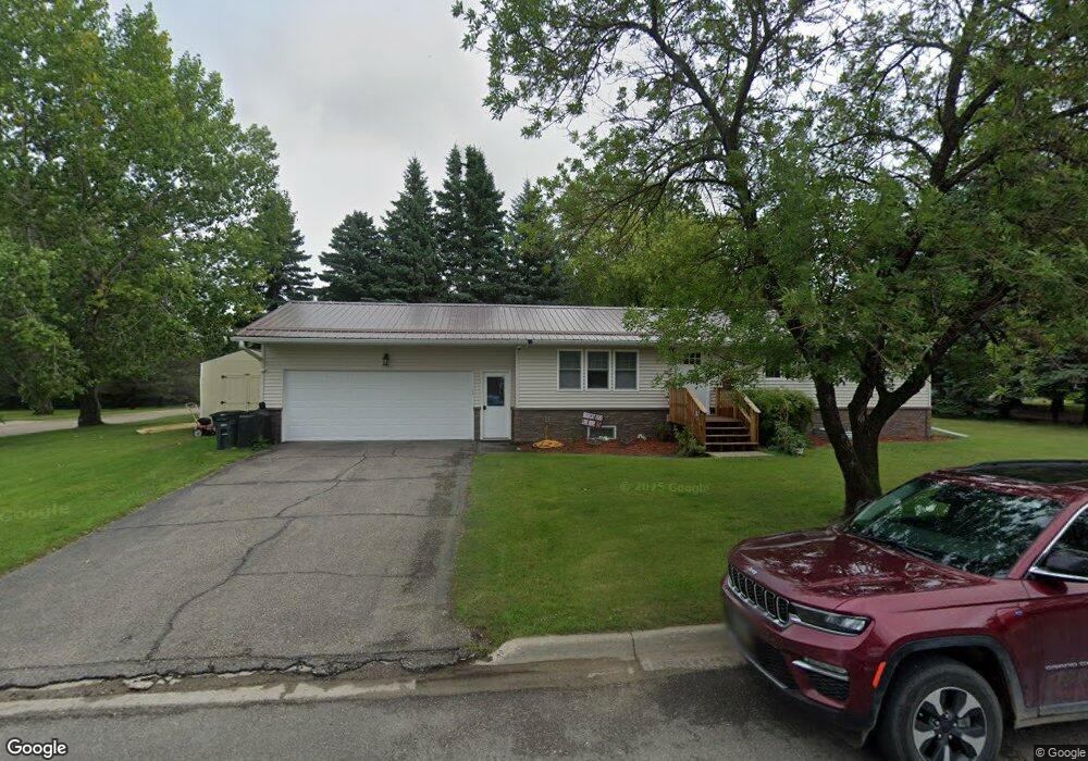
This home is located at 601 9th Ave, Cando, ND 58324 and is currently estimated at $227,568, approximately $198 per square foot. 601 9th Ave is a home with nearby schools including North Star High School.
Ownership History
Date
Name
Owned For
Owner Type
Purchase Details
Closed on
Jul 19, 2024
Sold by
Lewallen Bruce and Lewallen Karen
Bought by
Juarez Richard
Current Estimated Value
Home Financials for this Owner
Home Financials are based on the most recent Mortgage that was taken out on this home.
Original Mortgage
$225,834
Outstanding Balance
$217,315
Interest Rate
0.68%
Mortgage Type
Construction
Estimated Equity
$10,253
Purchase Details
Closed on
Apr 10, 2023
Sold by
Eisenzimmer Richard
Bought by
Lewallen Bruce and Weber Chad
Create a Home Valuation Report for This Property
The Home Valuation Report is an in-depth analysis detailing your home's value as well as a comparison with similar homes in the area
Purchase History
| Date | Buyer | Sale Price | Title Company |
|---|---|---|---|
| Juarez Richard | $230,000 | Attorney Only | |
| Lewallen Bruce | $125,000 | Attorney Only |
Source: Public Records
Mortgage History
| Date | Status | Borrower | Loan Amount |
|---|---|---|---|
| Open | Juarez Richard | $225,834 |
Source: Public Records
Tax History
| Year | Tax Paid | Tax Assessment Tax Assessment Total Assessment is a certain percentage of the fair market value that is determined by local assessors to be the total taxable value of land and additions on the property. | Land | Improvement |
|---|---|---|---|---|
| 2025 | $2,618 | $80,100 | $5,750 | $74,350 |
| 2024 | $2,115 | $68,150 | $5,750 | $62,400 |
| 2023 | $1,849 | $62,450 | $5,750 | $56,700 |
| 2022 | $1,681 | $57,500 | $5,750 | $51,750 |
| 2021 | $1,593 | $55,350 | $5,750 | $49,600 |
| 2020 | $1,573 | $55,350 | $5,750 | $49,600 |
| 2019 | $1,476 | $55,350 | $5,750 | $49,600 |
| 2018 | $1,339 | $50,900 | $5,750 | $45,150 |
| 2017 | $1,069 | $41,600 | $5,750 | $35,850 |
| 2016 | $869 | $38,650 | $4,600 | $34,050 |
| 2015 | $876 | $37,750 | $0 | $0 |
| 2014 | $877 | $35,400 | $4,600 | $30,800 |
Source: Public Records
Map
Nearby Homes
- 801 Evergreen Ln
- 616 9th St (Hwy 17) St
- 926 6th Ave
- 811 4th Ave
- 310 Main St Unit 6
- 210 3rd Ave
- Tbd State Highway 66
- TBD N Dakota 66
- 7115 86th St NE
- 7 Metigoshe Estates Rd
- 8542 60th Ave NE
- Tbd 53rd Ave NE
- 206 Leslie Ave N
- 405 Main St E
- 225 1st St SW
- 340 2nd Ave SW
- 102 Railroad Ave S
- 2012 Daniels Dr
- TBD 95 St Ne Parcel 3
- Lot 16 Blk 1 Scooby's Point
Your Personal Tour Guide
Ask me questions while you tour the home.