605 Taylor Pointe Ct Ballwin, MO 63011
Estimated Value: $457,664 - $546,000
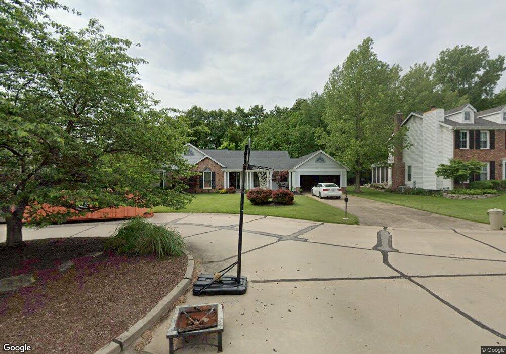
About This Home
This home is located at 605 Taylor Pointe Ct, Ballwin, MO 63011 and is currently estimated at $506,416, approximately $223 per square foot. 605 Taylor Pointe Ct is a home located in St. Louis County with nearby schools including Babler Elementary School, Rockwood Valley Middle School, and Lafayette High School.
Ownership History
We collect this data history from publicly available records. To have your information removed, we recommend requesting removal directly through your county’s website.
Purchase Details
Purchase Details
Home Financials for this Owner
Home Financials are based on the most recent Mortgage that was taken out on this home.Home Values in the Area
Average Home Value in this Area
Purchase History
We collect this data history from publicly available records. To have your information removed, we recommend requesting removal directly through your county’s website.
| Date | Buyer | Sale Price | Title Company |
|---|---|---|---|
| -- | None Available | ||
| $217,600 | -- |
Mortgage History
We collect this data history from publicly available records. To have your information removed, we recommend requesting removal directly through your county’s website.
| Date | Status | Borrower | Loan Amount |
|---|---|---|---|
| Closed | $217,600 |
Tax History
We collect this data history from publicly available records. To have your information removed, we recommend requesting removal directly through your county’s website.
| Year | Tax Paid | Tax Assessment Tax Assessment Total Assessment is a certain percentage of the fair market value that is determined by local assessors to be the total taxable value of land and additions on the property. | Land | Improvement |
|---|---|---|---|---|
| 2025 | $5,087 | $67,820 | $22,120 | $45,700 |
| 2024 | $5,087 | $73,150 | $19,870 | $53,280 |
| 2023 | $5,082 | $73,150 | $19,870 | $53,280 |
| 2022 | $4,657 | $62,260 | $13,980 | $48,280 |
| 2021 | $4,623 | $62,260 | $13,980 | $48,280 |
| 2020 | $4,708 | $60,450 | $13,980 | $46,470 |
| 2019 | $4,727 | $60,450 | $13,980 | $46,470 |
| 2018 | $4,851 | $58,500 | $13,980 | $44,520 |
| 2017 | $4,735 | $58,500 | $13,980 | $44,520 |
| 2016 | $3,868 | $45,960 | $13,980 | $31,980 |
| 2015 | $3,789 | $45,960 | $13,980 | $31,980 |
| 2014 | $4,396 | $52,000 | $10,390 | $41,610 |
Map
- 18024 Cider Mill Dr
- 16365 Peppermill Dr
- 1706 Big Horn Basin Dr
- 16404 Clayton Rd
- 16608 Clayton Rd
- 16627 Clayton Rd
- 16231 Pepper View Ct
- 212 Turnberry Place Dr
- 261 Turnberry Place Dr
- 724 Oaksdale Summit Ct
- 18005 Indian Tree Run
- 16611 Highland Summit Dr
- 310 Berry Bush Ct
- 18110 Linden Grove Ln
- 17531 Garden Ridge Cir
- 1634 Strecker Ridge Ct
- 461 Thunderhead Canyon Dr
- 1432 Shepard Rd
- 2437 Powders Mill Dr
- 1559 Englebrook Dr
- 609 Taylor Pointe Ct
- 601 Taylor Pointe Ct
- 608 Taylor Pointe Ct
- 613 Taylor Pointe Ct
- 600 Taylor Pointe Ct
- 604 Taylor Pointe Ct
- 612 Taylor Pointe Ct
- 616 Taylor Pointe Ct
- 617 Taylor Pointe Ct
- 611 Martin Pointe Ct
- 607 Martin Pointe Ct
- 615 Martin Pointe Ct
- 603 Martin Pointe Ct
- 620 Taylor Pointe Ct
- 1842 Sullivan Pointe Dr
- 621 Taylor Pointe Ct
- 550 McBride Pointe Dr
- 558 McBride Pointe Dr
- 562 McBride Pointe Dr
- 546 McBride Pointe Dr
Ask me questions while you tour the home.