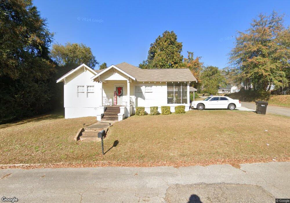
609 E 6th St West Point, GA 31833
Estimated Value: $130,000 - $167,000
3
Beds
2
Baths
1,800
Sq Ft
$85/Sq Ft
Est. Value
About This Home
This home is located at 609 E 6th St, West Point, GA 31833 and is currently estimated at $152,657, approximately $84 per square foot. 609 E 6th St is a home located in Troup County with nearby schools including West Point Elementary School, Long Cane Elementary School, and Whitesville Road Elementary School.
Ownership History
Date
Name
Owned For
Owner Type
Purchase Details
Closed on
Jul 19, 2002
Sold by
Paula Skipper
Bought by
Williams Eric M and Williams Ametris L
Current Estimated Value
Purchase Details
Closed on
Mar 14, 2001
Sold by
Blanche A Power
Bought by
Paula Skipper
Purchase Details
Closed on
Jul 25, 2000
Sold by
Sherry Langley Duffie
Bought by
Blanche A Power
Purchase Details
Closed on
Jun 14, 1999
Sold by
Blanche A Power
Bought by
Sherry Langley Duffie
Purchase Details
Closed on
Jan 1, 1927
Sold by
Johnson C H
Bought by
Blanche A Power
Create a Home Valuation Report for This Property
The Home Valuation Report is an in-depth analysis detailing your home's value as well as a comparison with similar homes in the area
Home Values in the Area
Average Home Value in this Area
Purchase History
We collect this data history from publicly available records. To have your information removed, we recommend requesting removal directly through your county’s website.
| Date | Buyer | Sale Price | Title Company |
|---|---|---|---|
| Williams Eric M | $72,000 | -- | |
| Paula Skipper | $63,500 | -- | |
| Blanche A Power | -- | -- | |
| Sherry Langley Duffie | $60,000 | -- | |
| Blanche A Power | -- | -- |
Source: Public Records
Tax History
| Year | Tax Paid | Tax Assessment Tax Assessment Total Assessment is a certain percentage of the fair market value that is determined by local assessors to be the total taxable value of land and additions on the property. | Land | Improvement |
|---|---|---|---|---|
| 2025 | $1,643 | $56,880 | $3,080 | $53,800 |
| 2024 | $1,371 | $40,280 | $3,080 | $37,200 |
| 2023 | $1,376 | $40,160 | $3,080 | $37,080 |
| 2022 | $1,014 | $38,320 | $3,080 | $35,240 |
| 2021 | $1,140 | $39,800 | $3,080 | $36,720 |
| 2020 | $984 | $34,600 | $1,720 | $32,880 |
| 2019 | $923 | $32,580 | $1,740 | $30,840 |
| 2018 | $878 | $31,100 | $1,740 | $29,360 |
| 2017 | $878 | $31,100 | $1,740 | $29,360 |
| 2016 | $847 | $30,061 | $1,740 | $28,321 |
| 2015 | $848 | $30,061 | $1,740 | $28,321 |
| 2014 | $805 | $28,570 | $1,740 | $26,830 |
| 2013 | -- | $30,409 | $1,740 | $28,669 |
Source: Public Records
Map
Nearby Homes
- 707 E 7th St
- 509 E 7th St
- 1202 E 9th St
- 900 E 9th St
- 1104 E 8th St
- 0 Arrowhead Dr Unit 10451860
- 112 Hillcrest Rd
- 604 Pear St
- 1418 E 10th St
- 712 4th Ave
- 0 Sunset Dr Unit 10451831
- 1007 4th Ave
- 1026 N 6th Ave
- 1604 U S 29
- 1508 N 4th Ave
- 302 N 6th Ave
- 514 N 8th Ave
- 507 N 16th St
- 1805 US Highway 29
- 608 S 1st Ave
Your Personal Tour Guide
Ask me questions while you tour the home.