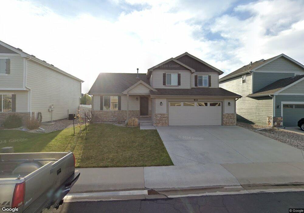
611 Denali Ct Windsor, CO 80550
Estimated Value: $476,000 - $508,000
3
Beds
2
Baths
1,522
Sq Ft
$324/Sq Ft
Est. Value
About This Home
This home is located at 611 Denali Ct, Windsor, CO 80550 and is currently estimated at $492,443, approximately $323 per square foot. 611 Denali Ct is a home located in Weld County with nearby schools including Severance Middle School, Windsor High School, and Windsor Charter Academy Elementary School.
Ownership History
Date
Name
Owned For
Owner Type
Purchase Details
Closed on
Dec 20, 2019
Sold by
Firehook Properties Llc
Bought by
611 Denali Llc
Current Estimated Value
Purchase Details
Closed on
Mar 28, 2013
Sold by
L-R Properties Llc
Bought by
Firehook Properties Llc
Purchase Details
Closed on
Feb 24, 2012
Sold by
Prestige Homes Llc
Bought by
L R Properties Llc
Create a Home Valuation Report for This Property
The Home Valuation Report is an in-depth analysis detailing your home's value as well as a comparison with similar homes in the area
Purchase History
| Date | Buyer | Sale Price | Title Company |
|---|---|---|---|
| 611 Denali Llc | -- | None Available | |
| Firehook Properties Llc | -- | None Available | |
| L R Properties Llc | $198,000 | Land Title Guarantee Company |
Source: Public Records
Tax History
| Year | Tax Paid | Tax Assessment Tax Assessment Total Assessment is a certain percentage of the fair market value that is determined by local assessors to be the total taxable value of land and additions on the property. | Land | Improvement |
|---|---|---|---|---|
| 2025 | $3,508 | $28,990 | $7,500 | $21,490 |
| 2024 | $3,508 | $28,990 | $7,500 | $21,490 |
| 2023 | $3,297 | $31,320 | $6,770 | $24,550 |
| 2022 | $3,135 | $23,140 | $6,320 | $16,820 |
| 2021 | $3,008 | $23,810 | $6,510 | $17,300 |
| 2020 | $2,938 | $22,810 | $5,010 | $17,800 |
| 2019 | $2,940 | $22,810 | $5,010 | $17,800 |
| 2018 | $2,920 | $20,750 | $5,040 | $15,710 |
| 2017 | $2,986 | $20,750 | $5,040 | $15,710 |
| 2016 | $2,600 | $17,920 | $3,420 | $14,500 |
| 2015 | $2,485 | $17,920 | $3,420 | $14,500 |
| 2014 | $2,303 | $15,960 | $2,790 | $13,170 |
Source: Public Records
Map
Nearby Homes
- 621 Denali Ct
- 632 Denali Ct
- 551 Wind River Dr
- 551 Vermilion Peak Dr
- 295 Redmond Dr
- 548 Dakota Way
- 623 Vermilion Peak Dr
- 175 Boxwood Dr
- 77 Boxwood Dr
- 250 Sutherland Dr
- 670 Moonglow Dr
- 633 Shoshone Ct
- 244 Veronica Dr
- 651 Hillspire Dr
- 366 Bluestar Dr
- 293 Turnberry Dr
- 283 Turnberry Dr
- 273 Turnberry Dr
- 356 Blue Star Dr
- 825 Shirttail Peak Dr
- 601 Denali Ct
- 612 Wind River Ct
- 602 Wind River Ct
- 631 Denali Ct
- 622 Wind River Ct
- 612 Denali Ct
- 602 Denali Ct
- 632 Wind River Ct
- 622 Denali Ct
- 610 Saratoga Way
- 620 Saratoga Way
- 642 Wind River Ct
- 600 Saratoga Way
- 630 Saratoga Way
- 590 Wind River Dr
- 601 Yukon Ct
- 611 Yukon Ct
- 642 Denali Ct
- 621 Yukon Ct
- 611 Wind River Ct
Your Personal Tour Guide
Ask me questions while you tour the home.