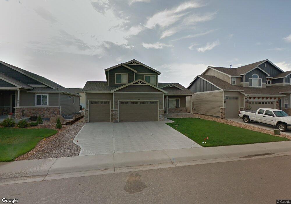
611 Wind River Ct Windsor, CO 80550
Estimated Value: $535,000 - $668,000
3
Beds
3
Baths
1,935
Sq Ft
$313/Sq Ft
Est. Value
About This Home
This home is located at 611 Wind River Ct, Windsor, CO 80550 and is currently estimated at $606,194, approximately $313 per square foot. 611 Wind River Ct is a home located in Weld County with nearby schools including Severance Middle School, Windsor High School, and Windsor Charter Academy Elementary School.
Ownership History
Date
Name
Owned For
Owner Type
Purchase Details
Closed on
Aug 18, 2011
Sold by
Sage Homes Llc
Bought by
Ehlers Nathan A and Ehlers Natalie L
Current Estimated Value
Home Financials for this Owner
Home Financials are based on the most recent Mortgage that was taken out on this home.
Original Mortgage
$242,349
Outstanding Balance
$166,626
Interest Rate
4.65%
Mortgage Type
FHA
Estimated Equity
$439,568
Purchase Details
Closed on
Apr 15, 2011
Sold by
Winter Farm Windsor Llc
Bought by
Sage Homes Llc
Create a Home Valuation Report for This Property
The Home Valuation Report is an in-depth analysis detailing your home's value as well as a comparison with similar homes in the area
Purchase History
| Date | Buyer | Sale Price | Title Company |
|---|---|---|---|
| Ehlers Nathan A | $248,659 | Land Title Guarantee Company | |
| Sage Homes Llc | $140,000 | Land Title Guarantee Company |
Source: Public Records
Mortgage History
| Date | Status | Borrower | Loan Amount |
|---|---|---|---|
| Open | Ehlers Nathan A | $242,349 |
Source: Public Records
Tax History
| Year | Tax Paid | Tax Assessment Tax Assessment Total Assessment is a certain percentage of the fair market value that is determined by local assessors to be the total taxable value of land and additions on the property. | Land | Improvement |
|---|---|---|---|---|
| 2025 | $4,644 | $36,710 | $7,500 | $29,210 |
| 2024 | $4,644 | $36,710 | $7,500 | $29,210 |
| 2023 | $4,365 | $40,250 | $6,770 | $33,480 |
| 2022 | $3,945 | $29,120 | $6,320 | $22,800 |
| 2021 | $3,786 | $29,970 | $6,510 | $23,460 |
| 2020 | $3,686 | $28,620 | $5,010 | $23,610 |
| 2019 | $3,444 | $26,720 | $5,010 | $21,710 |
| 2018 | $3,549 | $25,220 | $5,040 | $20,180 |
| 2017 | $3,630 | $25,220 | $5,040 | $20,180 |
| 2016 | $3,305 | $22,780 | $3,420 | $19,360 |
| 2015 | $3,159 | $22,780 | $3,420 | $19,360 |
| 2014 | $2,593 | $17,970 | $2,790 | $15,180 |
Source: Public Records
Map
Nearby Homes
- 621 Denali Ct
- 632 Denali Ct
- 551 Wind River Dr
- 623 Vermilion Peak Dr
- 295 Redmond Dr
- 633 Shoshone Ct
- 175 Boxwood Dr
- 77 Boxwood Dr
- 240 Hillspire Dr
- 244 Veronica Dr
- 670 Moonglow Dr
- 848 Shirttail Peak Dr
- 293 Turnberry Dr
- 283 Turnberry Dr
- 273 Turnberry Dr
- 366 Bluestar Dr
- 356 Blue Star Dr
- 336 Blue Star Dr
- 284 Veronica Dr
- 274 Veronica Dr
- 621 Wind River Ct
- 601 Wind River Ct
- 631 Wind River Ct
- 612 Babine Ct
- 622 Babine Ct
- 602 Babine Ct
- 612 Wind River Ct
- 632 Babine Ct
- 602 Wind River Ct
- 622 Wind River Ct
- 641 Wind River Ct
- 599 Wind River Dr
- 632 Wind River Ct
- 642 Babine Ct
- 652 Babine Ct
- 651 Wind River Ct
- 642 Wind River Ct
- 600 Saratoga Way
- 591 Wind River Dr
- 601 Denali Ct
Your Personal Tour Guide
Ask me questions while you tour the home.