Estimated Value: $302,000 - $343,000
3
Beds
2
Baths
1,555
Sq Ft
$206/Sq Ft
Est. Value
About This Home
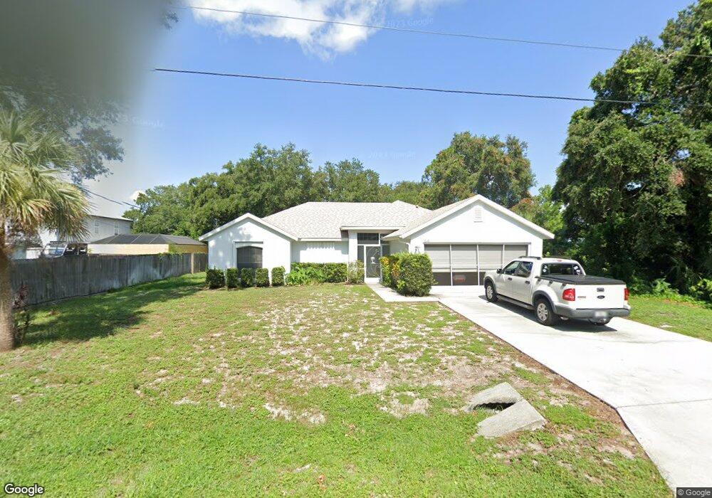
This home is located at 6181 Dees Rd, Cocoa, FL 32927 and is currently estimated at $321,027, approximately $206 per square foot. 6181 Dees Rd is a home located in Brevard County with nearby schools including Enterprise Elementary School, Space Coast Junior/Senior High School, and East Atlantic Prep of Brevard County.
Ownership History
Date
Name
Owned For
Owner Type
Purchase Details
Closed on
Dec 30, 2025
Sold by
Bishop Michael and Calvert Joan E
Bought by
Joan E Calvert Trust and Bassett
Current Estimated Value
Purchase Details
Closed on
Apr 9, 2014
Sold by
Calvert Joan E and Joan E Calvert Trust
Bought by
Calvert Joan E and Joan E Calvert Trust
Purchase Details
Closed on
Apr 19, 2005
Sold by
Renar Development Co
Bought by
Calvert Joan E and Joan E Calvert Trust
Purchase Details
Closed on
Mar 10, 2004
Sold by
Tapia Francis V and Tapia Delilah P
Bought by
K & J Land Development Inc
Purchase Details
Closed on
Mar 5, 2004
Sold by
K & J Land Development Inc
Bought by
Renar Development Co
Purchase Details
Closed on
Mar 25, 1996
Sold by
Nationsbank Fl N A
Bought by
Tapia Francis V and Tapia Delilah P
Create a Home Valuation Report for This Property
The Home Valuation Report is an in-depth analysis detailing your home's value as well as a comparison with similar homes in the area
Home Values in the Area
Average Home Value in this Area
Purchase History
| Date | Buyer | Sale Price | Title Company |
|---|---|---|---|
| Joan E Calvert Trust | $100 | None Listed On Document | |
| Calvert Joan E | -- | Attorney | |
| Calvert Joan E | $180,000 | Precise Title Inc | |
| K & J Land Development Inc | $18,500 | Precise Title Inc | |
| Renar Development Co | $24,000 | Precise Title Inc | |
| Tapia Francis V | $14,400 | -- |
Source: Public Records
Tax History
| Year | Tax Paid | Tax Assessment Tax Assessment Total Assessment is a certain percentage of the fair market value that is determined by local assessors to be the total taxable value of land and additions on the property. | Land | Improvement |
|---|---|---|---|---|
| 2025 | $1,314 | $99,850 | -- | -- |
| 2024 | $1,275 | $97,040 | -- | -- |
| 2023 | $1,275 | $94,220 | $0 | $0 |
| 2022 | $1,241 | $91,480 | $0 | $0 |
| 2021 | $1,235 | $88,820 | $0 | $0 |
| 2020 | $1,171 | $87,600 | $0 | $0 |
| 2019 | $1,106 | $85,640 | $0 | $0 |
| 2018 | $1,097 | $84,050 | $0 | $0 |
| 2017 | $1,087 | $82,330 | $0 | $0 |
| 2016 | $1,085 | $80,640 | $18,000 | $62,640 |
| 2015 | $1,093 | $80,080 | $15,000 | $65,080 |
| 2014 | $1,093 | $79,450 | $11,000 | $68,450 |
Source: Public Records
Map
Nearby Homes
- 6085 Edison St
- 6150 Baltimore Ave
- 00000 Golfview Ave
- 6230 Balsam St
- 6220 Golfview Ave
- 6180 Balboa St
- 6250 Ainsworth Rd
- 6215 Balboa St
- 23-35-21-JX-B-2 Aruin St
- 6460 Homestead Ave
- 5812 Homestead Ave
- 0 Aruin St Unit 1222557
- 6510 Aspen Ln
- 6460 Ainsworth Rd
- 6545 Addie Ave
- 6135 Allmont St
- 6115 Allmont St
- 6490 Addax Ave
- 5721 Beaverbrook St
- 5680 Banos Ave
Your Personal Tour Guide
Ask me questions while you tour the home.