Estimated Value: $257,000 - $305,000
3
Beds
2
Baths
1,200
Sq Ft
$227/Sq Ft
Est. Value
About This Home
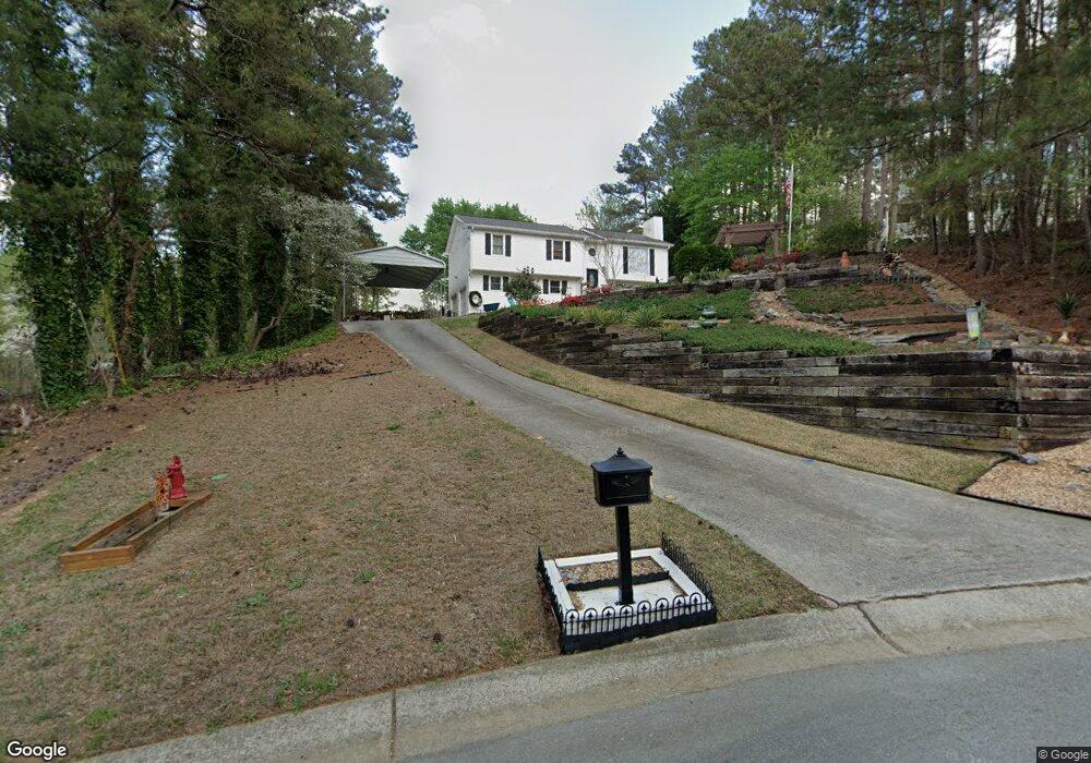
This home is located at 62 Forest Dr, Hiram, GA 30141 and is currently estimated at $272,708, approximately $227 per square foot. 62 Forest Dr is a home located in Paulding County with nearby schools including Sam D. Panter Elementary School, J. A. Dobbins Middle School, and Hiram High School.
Ownership History
Date
Name
Owned For
Owner Type
Purchase Details
Closed on
Nov 19, 2020
Sold by
Malinowski John H
Bought by
Malinowski John Henry and Shives Malinowski Beverly
Current Estimated Value
Home Financials for this Owner
Home Financials are based on the most recent Mortgage that was taken out on this home.
Original Mortgage
$128,000
Outstanding Balance
$112,425
Interest Rate
2.8%
Mortgage Type
New Conventional
Estimated Equity
$160,283
Purchase Details
Closed on
Sep 14, 1992
Sold by
Arbor Square Inc
Bought by
Malinowski John H
Purchase Details
Closed on
May 18, 1992
Sold by
H & K Properties Inc
Create a Home Valuation Report for This Property
The Home Valuation Report is an in-depth analysis detailing your home's value as well as a comparison with similar homes in the area
Home Values in the Area
Average Home Value in this Area
Purchase History
| Date | Buyer | Sale Price | Title Company |
|---|---|---|---|
| Malinowski John Henry | -- | -- | |
| Malinowski John H | $66,900 | -- | |
| -- | $8,000 | -- |
Source: Public Records
Mortgage History
| Date | Status | Borrower | Loan Amount |
|---|---|---|---|
| Open | Malinowski John Henry | $128,000 |
Source: Public Records
Tax History
| Year | Tax Paid | Tax Assessment Tax Assessment Total Assessment is a certain percentage of the fair market value that is determined by local assessors to be the total taxable value of land and additions on the property. | Land | Improvement |
|---|---|---|---|---|
| 2025 | $763 | $115,840 | $12,000 | $103,840 |
| 2024 | $763 | $114,560 | $12,000 | $102,560 |
| 2023 | $863 | $109,744 | $12,000 | $97,744 |
| 2022 | $1,294 | $82,356 | $12,000 | $70,356 |
| 2021 | $1,228 | $69,228 | $8,000 | $61,228 |
| 2020 | $1,210 | $66,304 | $8,000 | $58,304 |
| 2019 | $1,011 | $55,428 | $8,000 | $47,428 |
| 2018 | $916 | $51,024 | $6,000 | $45,024 |
| 2017 | $1,456 | $49,524 | $6,000 | $43,524 |
| 2016 | $1,317 | $45,430 | $6,000 | $39,430 |
| 2015 | $1,070 | $36,618 | $6,000 | $30,618 |
| 2014 | $649 | $22,409 | $6,000 | $16,409 |
| 2013 | -- | $18,240 | $6,000 | $12,240 |
Source: Public Records
Map
Nearby Homes
- 74 Bonds Ct
- 178 Laird Rd
- 7606 Nebo Rd
- 725 Laird Rd
- 7012 Nebo Rd
- 278 Willow Bend Dr
- 149 Willow Bend Rd
- 133 Willow Bend Rd
- 2690 Hiram Douglasville Hwy
- 165 Willow Bend Dr
- 2393 Bill Carruth Pkwy
- 6488 Nebo Rd
- 143 Birch St
- 552 Rich Davis Rd
- 28 Lanier Crossing
- 108 Vickie Dr
- 124 Ashley Pointe Dr
- 487 Valerie Cir
- 238 Dallas St
- 3065 Hiram Sudie Rd
Your Personal Tour Guide
Ask me questions while you tour the home.