Estimated Value: $99,504 - $192,000
2
Beds
1
Bath
953
Sq Ft
$151/Sq Ft
Est. Value
About This Home
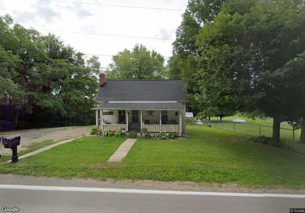
This home is located at 6215 State Route 296, Cable, OH 43009 and is currently estimated at $144,126, approximately $151 per square foot. 6215 State Route 296 is a home located in Champaign County with nearby schools including Triad Elementary School, Triad Middle School, and Triad High School.
Ownership History
Date
Name
Owned For
Owner Type
Purchase Details
Closed on
Jul 12, 2023
Sold by
Payne Tanner J
Bought by
Laird Donna Jean and Laird Ronald Dee
Current Estimated Value
Home Financials for this Owner
Home Financials are based on the most recent Mortgage that was taken out on this home.
Original Mortgage
$101,010
Outstanding Balance
$97,992
Interest Rate
6.79%
Mortgage Type
New Conventional
Estimated Equity
$46,134
Purchase Details
Closed on
Nov 20, 2015
Sold by
Rannes Judith A and Rannes James Allen
Bought by
Payne Tanner J
Home Financials for this Owner
Home Financials are based on the most recent Mortgage that was taken out on this home.
Original Mortgage
$39,950
Interest Rate
3.74%
Mortgage Type
Commercial
Create a Home Valuation Report for This Property
The Home Valuation Report is an in-depth analysis detailing your home's value as well as a comparison with similar homes in the area
Purchase History
| Date | Buyer | Sale Price | Title Company |
|---|---|---|---|
| Laird Donna Jean | $100,000 | Heart Of Ohio Title | |
| Payne Tanner J | $47,000 | None Available |
Source: Public Records
Mortgage History
| Date | Status | Borrower | Loan Amount |
|---|---|---|---|
| Open | Laird Donna Jean | $101,010 | |
| Previous Owner | Payne Tanner J | $39,950 |
Source: Public Records
Tax History
| Year | Tax Paid | Tax Assessment Tax Assessment Total Assessment is a certain percentage of the fair market value that is determined by local assessors to be the total taxable value of land and additions on the property. | Land | Improvement |
|---|---|---|---|---|
| 2025 | $1,200 | $33,240 | $3,840 | $29,400 |
| 2024 | $1,200 | $21,700 | $2,560 | $19,140 |
| 2023 | $860 | $21,700 | $2,560 | $19,140 |
| 2022 | $843 | $21,700 | $2,560 | $19,140 |
| 2021 | $729 | $17,360 | $2,050 | $15,310 |
| 2020 | $729 | $17,360 | $2,050 | $15,310 |
| 2019 | $718 | $17,360 | $2,050 | $15,310 |
| 2018 | $573 | $13,960 | $1,790 | $12,170 |
| 2017 | $543 | $13,960 | $1,790 | $12,170 |
| 2016 | $540 | $13,960 | $1,790 | $12,170 |
| 2015 | $524 | $13,680 | $1,780 | $11,900 |
| 2014 | $521 | $13,680 | $1,780 | $11,900 |
| 2013 | $517 | $13,680 | $1,780 | $11,900 |
Source: Public Records
Map
Nearby Homes
- 5061 Cox Rd
- 7521 Brush Lake Rd
- 5886 Fillmore St
- 6507 Spain St
- 6683 Cable Rd
- 6704 Stevenson Rd
- 8389 Mingo Lewisburg Rd
- 8389 Mingo-Lewisburg Rd
- 0 Yocom Rd
- Lot 2 N Ludlow Rd
- 125 Lincoln Place
- 0 Lincoln Place Unit 226000852
- 0 Lincoln Place Unit 1044601
- 106 Cherry St
- 10343 Urbana Woodstock Pike
- 1992 Kennard Kingscreek Rd
- 3314 Stone Quarry Rd
- 7181 Long Pond Rd
- 7588 Stringtown Rd
- 4893 N US Highway 68
- 6215 Ohio 296
- 6225 State Route 296
- 6250 State Route 296
- 1 Brush Lake Rd
- 6241 State Route 245
- 6262 State Route 245
- 6262 Ohio 245
- 6275 Brush Lake Rd
- 0 Brush Lake Rd Unit 2718199
- 0 Brush Lake Rd Unit 2540121
- 0 Brush Lake Rd Unit 2535683
- 0 Brush Lake Rd Unit 2448565
- 0 Brush Lake Rd Unit 2837375
- 0 Brush Lake Rd Unit 2937616
- 0 Brush Lake Rd Unit 211024622
- 0 Brush Lake Rd Unit 214011429
- 0 Brush Lake Rd Unit 277408
- 0 Brush Lake Rd Unit 330497
- 0 Brush Lake Rd Unit 301243
- 0 Brush Lake Rd Unit 318497
Your Personal Tour Guide
Ask me questions while you tour the home.