Estimated Value: $279,000 - $292,000
3
Beds
2
Baths
1,525
Sq Ft
$185/Sq Ft
Est. Value
About This Home
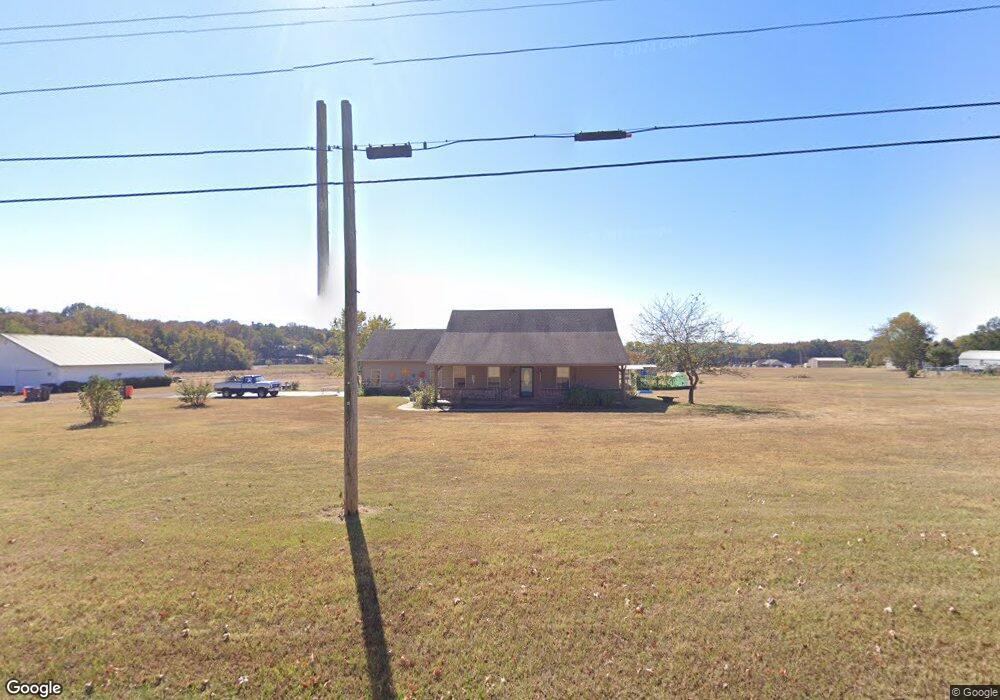
This home is located at 6220 Dean Rd, Alma, AR 72921 and is currently estimated at $282,842, approximately $185 per square foot. 6220 Dean Rd is a home located in Crawford County with nearby schools including Alma Intermediate School, Alma Primary School, and Alma Middle School.
Ownership History
Date
Name
Owned For
Owner Type
Purchase Details
Closed on
Jun 5, 2023
Sold by
Scott Christine
Bought by
Scott Jamie Ronald
Current Estimated Value
Purchase Details
Closed on
Nov 18, 2021
Sold by
Scott Jamie R
Bought by
Scott Ronald and Scott Christine
Purchase Details
Closed on
May 5, 2009
Sold by
Ervin Tony and Romero David C
Bought by
Scott Jamie R
Home Financials for this Owner
Home Financials are based on the most recent Mortgage that was taken out on this home.
Original Mortgage
$132,200
Interest Rate
4.84%
Mortgage Type
Purchase Money Mortgage
Create a Home Valuation Report for This Property
The Home Valuation Report is an in-depth analysis detailing your home's value as well as a comparison with similar homes in the area
Purchase History
We collect this data history from publicly available records. To have your information removed, we recommend requesting removal directly through your county’s website.
| Date | Buyer | Sale Price | Title Company |
|---|---|---|---|
| Scott Jamie Ronald | -- | None Listed On Document | |
| Scott Ronald | -- | None Available | |
| Scott Jamie R | $144,000 | -- |
Source: Public Records
Mortgage History
We collect this data history from publicly available records. To have your information removed, we recommend requesting removal directly through your county’s website.
| Date | Status | Borrower | Loan Amount |
|---|---|---|---|
| Previous Owner | Scott Jamie R | $132,200 |
Source: Public Records
Tax History
| Year | Tax Paid | Tax Assessment Tax Assessment Total Assessment is a certain percentage of the fair market value that is determined by local assessors to be the total taxable value of land and additions on the property. | Land | Improvement |
|---|---|---|---|---|
| 2025 | $1,232 | $48,750 | $4,940 | $43,810 |
| 2024 | $1,252 | $48,750 | $4,940 | $43,810 |
| 2023 | $1,248 | $48,750 | $4,940 | $43,810 |
| 2022 | $1,218 | $32,050 | $3,770 | $28,280 |
| 2021 | $1,218 | $32,050 | $3,770 | $28,280 |
| 2020 | $1,218 | $32,050 | $3,770 | $28,280 |
| 2019 | $1,250 | $32,050 | $3,770 | $28,280 |
| 2018 | $1,207 | $32,050 | $3,770 | $28,280 |
| 2017 | $1,132 | $29,240 | $3,770 | $25,470 |
| 2016 | $1,132 | $29,240 | $3,770 | $25,470 |
| 2015 | $1,132 | $29,240 | $3,770 | $25,470 |
| 2014 | $1,132 | $29,240 | $3,770 | $25,470 |
Source: Public Records
Map
Nearby Homes
- 2215 Deepwood Dr
- 3022 Dow Jones Rd
- 3819 Belmont Ranch Rd
- 7727 Belmont Dr
- 6235 Belmont Dr
- 5108 Ridge Rd
- 8128 Belmont Dr
- 4504 Ridge Rd
- 3828 Edwards Rd
- 5205 Georgia Ridge Rd
- 8761 Highway 282
- 233 McGarrah Ln
- 313 Stone Mountain Loop
- 513 Stone Mountain Loop
- TBD Abby Rose Ln
- 7911 & 7921 Walker School Rd
- 303 Fine Place
- 628 W Newberry Rd
- 2428 Winn Mountain Loop
- 2108 N Mountain Grove Rd
Your Personal Tour Guide
Ask me questions while you tour the home.