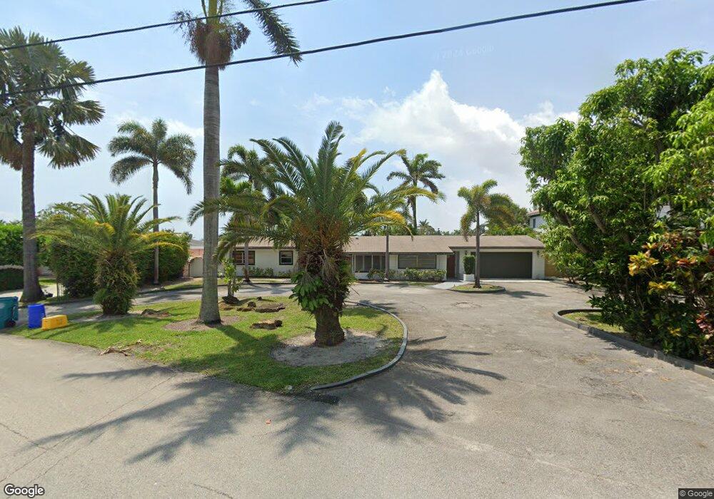
632 Shore Dr Boynton Beach, FL 33435
Boynton Bay NeighborhoodEstimated Value: $1,152,000 - $1,922,000
About This Home
This home is located at 632 Shore Dr, Boynton Beach, FL 33435 and is currently estimated at $1,694,019, approximately $567 per square foot. 632 Shore Dr is a home located in Palm Beach County with nearby schools including Rolling Green Elementary School, Boynton Beach Community High School, and Lantana Middle School.
Ownership History
We collect this data history from publicly available records. To have your information removed, we recommend requesting removal directly through your county’s website.
Purchase Details
Home Financials for this Owner
Home Financials are based on the most recent Mortgage that was taken out on this home.Purchase Details
Purchase Details
Home Financials for this Owner
Home Financials are based on the most recent Mortgage that was taken out on this home.Purchase Details
Home Values in the Area
Average Home Value in this Area
Purchase History
We collect this data history from publicly available records. To have your information removed, we recommend requesting removal directly through your county’s website.
| Date | Buyer | Sale Price | Title Company |
|---|---|---|---|
| -- | First American | ||
| -- | None Available | ||
| $200,000 | -- | ||
| -- | -- |
Mortgage History
We collect this data history from publicly available records. To have your information removed, we recommend requesting removal directly through your county’s website.
| Date | Status | Borrower | Loan Amount |
|---|---|---|---|
| Closed | $250,000 | ||
| Closed | $140,000 |
Tax History
We collect this data history from publicly available records. To have your information removed, we recommend requesting removal directly through your county’s website.
| Year | Tax Paid | Tax Assessment Tax Assessment Total Assessment is a certain percentage of the fair market value that is determined by local assessors to be the total taxable value of land and additions on the property. | Land | Improvement |
|---|---|---|---|---|
| 2025 | $6,279 | $353,645 | -- | -- |
| 2024 | $6,279 | $338,230 | -- | -- |
| 2023 | $6,107 | $328,379 | $0 | $0 |
| 2022 | $6,019 | $318,815 | $0 | $0 |
| 2021 | $5,977 | $309,529 | $0 | $0 |
| 2020 | $5,930 | $305,255 | $0 | $0 |
| 2019 | $5,842 | $298,392 | $0 | $0 |
| 2018 | $5,574 | $292,828 | $0 | $0 |
| 2017 | $5,518 | $286,805 | $0 | $0 |
| 2016 | $5,487 | $280,906 | $0 | $0 |
| 2015 | $5,058 | $255,031 | $0 | $0 |
| 2014 | $5,061 | $253,007 | $0 | $0 |
Map
- 634 Ocean Inlet Dr
- 622 Mariners Way
- 611 NE 12th Terrace Unit 1
- 720 Mariners Way
- 815 South Rd
- 718 NE 12th Terrace Unit 3
- 718 NE 12th Terrace Unit 4
- 416 NE 12th Ave
- 732 Rider Rd
- 743 NE 12th Terrace Unit 2
- 702 NE 10th Ave
- 647 NE 9th Ave
- 309 NE 11th Ave
- 16 Via Lago Unit B16
- 721 NE 8th Ave
- 416 Circle Dr S
- 1810 New Palm Way Unit 316
- 1810 New Palm Way Unit 415
- 1810 New Palm Way Unit 417
- 1820 New Palm Way Unit 202
- 638 Shore Dr
- 2040 Murano Bay Dr
- 2030 Murano Bay Dr Unit 9
- 2030 Murano Bay Dr
- 3000 Murano Bay Dr Unit 11
- 3000 Murano Bay Dr
- 2020 Murano Bay Dr
- 644 Shore Dr
- 2010 Murano Bay Dr
- 3030 Murano Bay Dr
- 3020 Murano Bay Dr
- 621 Shore Dr
- 2000 Murano Bay Dr
- 641 Shore Dr
- 1040 Murano Bay Dr Unit 5
- 1040 Murano Bay Dr
- 650 Shore Dr
- 3040 Murano Bay Dr
- 1030 Murano Bay Dr
- 647 Shore Dr
Ask me questions while you tour the home.