
Seller's Agent in 2026
Tracy Pulos
BHHS Fox & Roach
(610) 329-7399
3 in this area
178 Total Sales


Estimated Value: $1,023,000 - $1,364,000
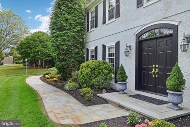
Offers due by Sat. 10/4 at noon! Set on a beautifully landscaped 1⁄2 acre lot in the popular Fox Fields neighborhood, this warm and inviting 4 BD, 2/1 BA French Colonial is the move-in ready home you’ve been waiting for! Impeccably maintained and updated, this home has modern, neutral décor which creates a soothing atmosphere. The circular floor plan has open views from the renovated Kitchen to the inviting Family Room, where you’ll enjoy curling up in front of the fireplace during winter months. The expanded Breakfast Room has a serving bar built-ins and opens to the rear yard. Enjoy entertaining in the large Living Room which opens to the formal Dining Room. Upstairs is a generous Primary Bedroom which is flooded with natural light. It features two closets and a remodeled Primary Bathroom with an extra deep bathtub. 3 more Hall Bedrooms share a 2nd Full Bathroom. The spacious, sunny upstairs Laundry Room makes doing that routine chore a pleasure. Drop off coats and other gear in the large rear Mudroom, with a bench and large closet, located just off the 2-car attached Garage. The finished Lower Level includes a TV area and separate game table area, 2nd powder room, built-in wet bar, and a partially finished utility/storage room. Ample space for recreation, fitness, and hobbies! Step outside to an expansive rear paver patio overlooking the beautifully landscaped 1⁄2-acre yard—ideal for outdoor entertaining and everyday enjoyment. A short stroll away, you’ll find abundant neighborhood open space – where neighbors can walk and enjoy nature... and kids can play (or go sledding in the winter!) Close to schools and parks. Convenient to the Haverford Community Recreation & Environmental Center, with easy access to Center City, shopping, and restaurants in Bryn Mawr and Ardmore. A rare opportunity in one of Haverford Township’s most desirable communities!
Last Agent to Sell the Property
(610) 651-2700 tracy.pulos@foxroach.com BHHS Fox & Roach Wayne-Devon License #RS226566L Listed on: 09/29/2025
Co-Listed By
(610) 651-2700 Mark.Pulos@foxroach.com BHHS Fox & Roach Wayne-Devon License #RS287936
We collect this data history from publicly available records. To have your information removed, we recommend requesting removal directly through your county’s website.
| Date | Buyer | Sale Price | Title Company |
|---|---|---|---|
| Kirkland Ronald | $1,275,000 | Sage Premier Settlements | |
| Johnson Ward S | $320,000 | -- |
We collect this data history from publicly available records. To have your information removed, we recommend requesting removal directly through your county’s website.
| Date | Status | Borrower | Loan Amount |
|---|---|---|---|
| Open | Kirkland Ronald | $637,500 | |
| Previous Owner | Johnson Ward S | $195,000 |
| Date | Event | Price | List to Sale | Price per Sq Ft |
|---|---|---|---|---|
| 01/06/2026 01/06/26 | Sold | $1,275,000 | +28.9% | $502 / Sq Ft |
| 10/06/2025 10/06/25 | Pending | -- | -- | -- |
| 09/29/2025 09/29/25 | For Sale | $989,000 | -- | $389 / Sq Ft |
| Year | Tax Paid | Tax Assessment Tax Assessment Total Assessment is a certain percentage of the fair market value that is determined by local assessors to be the total taxable value of land and additions on the property. | Land | Improvement |
|---|---|---|---|---|
| 2026 | $13,359 | $475,940 | $201,110 | $274,830 |
| 2025 | $13,359 | $475,940 | $201,110 | $274,830 |
| 2024 | $12,238 | $475,940 | $201,110 | $274,830 |
| 2023 | $11,890 | $475,940 | $201,110 | $274,830 |
| 2022 | $11,612 | $475,940 | $201,110 | $274,830 |
| 2021 | $18,917 | $475,940 | $201,110 | $274,830 |
| 2020 | $14,703 | $316,340 | $129,800 | $186,540 |
| 2019 | $14,432 | $316,340 | $129,800 | $186,540 |
| 2018 | $14,184 | $316,340 | $0 | $0 |
| 2017 | $13,884 | $316,340 | $0 | $0 |
| 2016 | $1,736 | $316,340 | $0 | $0 |
| 2015 | $1,772 | $316,340 | $0 | $0 |
| 2014 | $1,772 | $316,340 | $0 | $0 |
Seller's Agent in 2026
Tracy Pulos
BHHS Fox & Roach
(610) 329-7399
3 in this area
178 Total Sales
Seller Co-Listing Agent in 2026
Mark Pulos
BHHS Fox & Roach
(610) 416-4669
4 in this area
167 Total Sales
M
Buyer's Agent in 2026
Madelyn Trofa
Howard Hanna Real Estate Services
(610) 721-8177
1 in this area
16 Total Sales
Source: Bright MLS
MLS Number: PADE2100894
APN: 22-05-00343-25
Disclaimer: Certain information contained herein is derived from information provided by parties other than Homes.com. All information provided is deemed reliable, but is not guaranteed to be accurate and should be independently verified.
![]() The data relating to real estate for sale on this website appears in part through the BRIGHT Internet Data Exchange program, a voluntary cooperative exchange of property listing data between licensed real estate brokerage firms, and is provided by BRIGHT through a licensing agreement.
The data relating to real estate for sale on this website appears in part through the BRIGHT Internet Data Exchange program, a voluntary cooperative exchange of property listing data between licensed real estate brokerage firms, and is provided by BRIGHT through a licensing agreement.
Listing information is from various brokers who participate in the Bright MLS IDX program and not all listings may be visible on the site.
The property information being provided on or through the website is for the personal, non-commercial use of consumers and such information may not be used for any purpose other than to identify prospective properties consumers may be interested in purchasing.
Some properties which appear for sale on the website may no longer be available because they are for instance, under contract, sold or are no longer being offered for sale.
Property information displayed is deemed reliable but is not guaranteed.
Copyright 2026 Bright MLS, Inc.
Ask me questions while you tour the home.