Estimated Value: $240,760 - $281,000
3
Beds
2
Baths
1,053
Sq Ft
$250/Sq Ft
Est. Value
About This Home
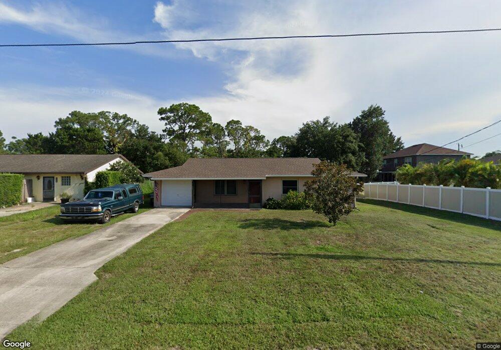
This home is located at 6340 Deer Ln, Cocoa, FL 32927 and is currently estimated at $262,940, approximately $249 per square foot. 6340 Deer Ln is a home located in Brevard County with nearby schools including Enterprise Elementary School, Space Coast Junior/Senior High School, and East Atlantic Prep of Brevard County.
Ownership History
Date
Name
Owned For
Owner Type
Purchase Details
Closed on
Jan 30, 2004
Sold by
Forton Bruce W
Bought by
Halcomb Kevin
Current Estimated Value
Home Financials for this Owner
Home Financials are based on the most recent Mortgage that was taken out on this home.
Original Mortgage
$92,000
Outstanding Balance
$43,208
Interest Rate
5.85%
Estimated Equity
$219,732
Create a Home Valuation Report for This Property
The Home Valuation Report is an in-depth analysis detailing your home's value as well as a comparison with similar homes in the area
Home Values in the Area
Average Home Value in this Area
Purchase History
| Date | Buyer | Sale Price | Title Company |
|---|---|---|---|
| Halcomb Kevin | $115,000 | Fidelity National Title Insu |
Source: Public Records
Mortgage History
| Date | Status | Borrower | Loan Amount |
|---|---|---|---|
| Open | Halcomb Kevin | $92,000 |
Source: Public Records
Tax History
| Year | Tax Paid | Tax Assessment Tax Assessment Total Assessment is a certain percentage of the fair market value that is determined by local assessors to be the total taxable value of land and additions on the property. | Land | Improvement |
|---|---|---|---|---|
| 2025 | $642 | $65,400 | -- | -- |
| 2024 | $626 | $63,560 | -- | -- |
| 2023 | $626 | $61,710 | $0 | $0 |
| 2022 | $600 | $59,920 | $0 | $0 |
| 2021 | $590 | $58,180 | $0 | $0 |
| 2020 | $553 | $57,380 | $0 | $0 |
| 2019 | $498 | $56,090 | $0 | $0 |
| 2018 | $494 | $55,050 | $0 | $0 |
| 2017 | $765 | $53,920 | $0 | $0 |
| 2016 | $770 | $52,820 | $18,000 | $34,820 |
| 2015 | $774 | $52,460 | $15,000 | $37,460 |
| 2014 | $779 | $52,050 | $11,000 | $41,050 |
Source: Public Records
Map
Nearby Homes
- 5680 Banos Ave
- 5721 Beaverbrook St
- 6481 La Brea Ave
- 6438 Hudson Rd
- 0 Aruin St Unit 1222557
- 6250 Ainsworth Rd
- 6460 Ainsworth Rd
- 23-35-21-JX-B-2 Aruin St
- 6581 Bancroft Ave
- 6460 Homestead Ave
- 6643 Emil Ave
- 6545 Addie Ave
- 6615 Dock Ave
- 6450 Ember Ave
- 6085 Edison St
- 5946 Deer Ln
- 5220 Holden Rd
- 5945 Coker Ave
- 6135 Allmont St
- 5221 Carrick Rd
- 6330 Deer Ln
- 6355 Macauley Ave
- 6345 Macauley Ave
- 6320 Deer Ln
- 6347 Deer Ln
- 6373 Macauley Ave
- 6335 Macauley Ave
- 6335 Deer Ln
- 6310 Deer Ln
- 6323 Deer Ln
- 6325 Macauley Ave
- 6350 Macauley Ave
- 6340 Macauley Ave
- 6385 Macauley Ave
- 5719 Banos Ave
- 5711 Banos Ave
- 6370 Macauley Ave
- 6330 Macauley Ave
- 5703 Banos Ave
- 6315 Macauley Ave
Your Personal Tour Guide
Ask me questions while you tour the home.