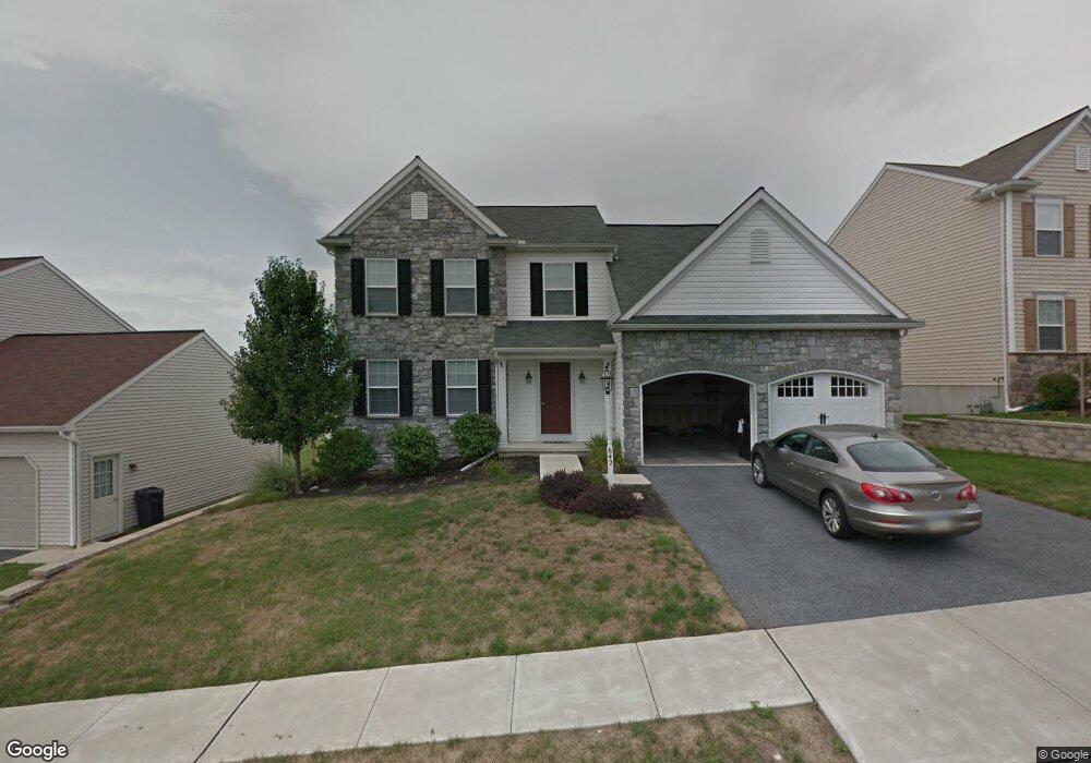
642 Hamaker Rd Manheim, PA 17545
Estimated Value: $427,992 - $531,000
3
Beds
2
Baths
2,348
Sq Ft
$209/Sq Ft
Est. Value
About This Home
This home is located at 642 Hamaker Rd, Manheim, PA 17545 and is currently estimated at $491,498, approximately $209 per square foot. 642 Hamaker Rd is a home located in Lancaster County with nearby schools including Manheim Central Senior High School, Manheim Christian Day School, and Sporting Hill Christian School.
Ownership History
Date
Name
Owned For
Owner Type
Purchase Details
Closed on
Jul 8, 2011
Sold by
Butzer Ryan M
Bought by
Hoke Timothy L and Bothell Jennifer L
Current Estimated Value
Home Financials for this Owner
Home Financials are based on the most recent Mortgage that was taken out on this home.
Original Mortgage
$248,535
Interest Rate
3.5%
Mortgage Type
FHA
Purchase Details
Closed on
Mar 25, 2010
Sold by
Maounis Dena M
Bought by
Butzer Ryan M
Create a Home Valuation Report for This Property
The Home Valuation Report is an in-depth analysis detailing your home's value as well as a comparison with similar homes in the area
Home Values in the Area
Average Home Value in this Area
Purchase History
| Date | Buyer | Sale Price | Title Company |
|---|---|---|---|
| Hoke Timothy L | $255,000 | None Available | |
| Butzer Ryan M | $212,500 | None Available |
Source: Public Records
Mortgage History
| Date | Status | Borrower | Loan Amount |
|---|---|---|---|
| Previous Owner | Hoke Timothy L | $248,535 |
Source: Public Records
Tax History
| Year | Tax Paid | Tax Assessment Tax Assessment Total Assessment is a certain percentage of the fair market value that is determined by local assessors to be the total taxable value of land and additions on the property. | Land | Improvement |
|---|---|---|---|---|
| 2025 | $5,264 | $258,200 | $54,700 | $203,500 |
| 2024 | $5,264 | $258,200 | $54,700 | $203,500 |
| 2023 | $5,153 | $258,200 | $54,700 | $203,500 |
| 2022 | $5,021 | $258,200 | $54,700 | $203,500 |
| 2021 | $4,907 | $258,200 | $54,700 | $203,500 |
| 2020 | $4,907 | $258,200 | $54,700 | $203,500 |
| 2019 | $4,822 | $258,200 | $54,700 | $203,500 |
| 2018 | $3,584 | $258,200 | $54,700 | $203,500 |
| 2017 | $6,118 | $262,500 | $36,700 | $225,800 |
| 2016 | $6,118 | $262,500 | $36,700 | $225,800 |
| 2015 | $1,453 | $262,500 | $36,700 | $225,800 |
| 2014 | $4,390 | $262,500 | $36,700 | $225,800 |
Source: Public Records
Map
Nearby Homes
- 820 Cambridge Dr Unit 77
- 714 Heather Ridge Unit 140
- 854 Cambridge Dr Unit 7
- 730 Heather Ridge Unit 146
- 900 Cambridge Dr
- 130 Julia Ln
- 81 S Linden St
- 55 S Hazel St
- 901 Cool Spring Rd
- 42 Market Square
- 216 N Pitt St
- 2 S Charlotte St
- 133 W High St
- 117 W Ferdinand St
- 142 W Stiegel St
- 327 Dover St
- 309 S Cherry St
- 579 Hi View Dr
- 222 Audrey Dr
- 662 Bedington Cir
- 638 Hamaker Rd
- 648 Hamaker Rd
- 630 Hamaker Rd
- 654 Hamaker Rd
- 468 Charles Dr
- 470 Charles Dr
- 466 Charles Dr
- 641 Hamaker Rd
- 641 Hamaker Rd Unit 11
- 645 Hamaker Rd
- 626 Hamaker Rd
- 637 Hamaker Rd
- 649 Hamaker Rd
- 472 Charles Dr
- 653 Hamaker Rd
- 633 Hamaker Rd
- 662 Hamaker Rd
- 622 Hamaker Rd
- 474 Charles Dr
- 460 Charles Dr
Your Personal Tour Guide
Ask me questions while you tour the home.