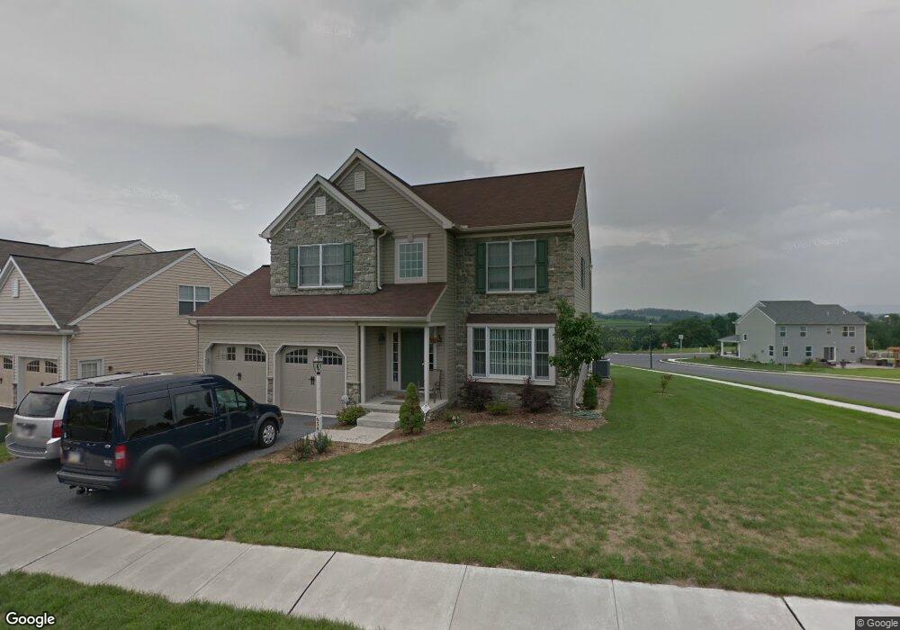
654 Hamaker Rd Manheim, PA 17545
Estimated Value: $467,000 - $548,000
3
Beds
3
Baths
3,482
Sq Ft
$143/Sq Ft
Est. Value
About This Home
This home is located at 654 Hamaker Rd, Manheim, PA 17545 and is currently estimated at $497,666, approximately $142 per square foot. 654 Hamaker Rd is a home located in Lancaster County with nearby schools including Manheim Central Senior High School, Manheim Christian Day School, and Sporting Hill Christian School.
Ownership History
Date
Name
Owned For
Owner Type
Purchase Details
Closed on
Jan 22, 2007
Sold by
Charles Investments Lp
Bought by
Gruel David M and Gruel Deborah R
Current Estimated Value
Home Financials for this Owner
Home Financials are based on the most recent Mortgage that was taken out on this home.
Original Mortgage
$317,119
Outstanding Balance
$188,876
Interest Rate
6.15%
Mortgage Type
Purchase Money Mortgage
Estimated Equity
$308,790
Create a Home Valuation Report for This Property
The Home Valuation Report is an in-depth analysis detailing your home's value as well as a comparison with similar homes in the area
Home Values in the Area
Average Home Value in this Area
Purchase History
| Date | Buyer | Sale Price | Title Company |
|---|---|---|---|
| Gruel David M | $333,810 | First American Title Ins Co |
Source: Public Records
Mortgage History
| Date | Status | Borrower | Loan Amount |
|---|---|---|---|
| Open | Gruel David M | $317,119 |
Source: Public Records
Tax History
| Year | Tax Paid | Tax Assessment Tax Assessment Total Assessment is a certain percentage of the fair market value that is determined by local assessors to be the total taxable value of land and additions on the property. | Land | Improvement |
|---|---|---|---|---|
| 2025 | $5,562 | $272,800 | $60,000 | $212,800 |
| 2024 | $5,562 | $272,800 | $60,000 | $212,800 |
| 2023 | $5,445 | $272,800 | $60,000 | $212,800 |
| 2022 | $5,305 | $272,800 | $60,000 | $212,800 |
| 2021 | $5,185 | $272,800 | $60,000 | $212,800 |
| 2020 | $5,185 | $272,800 | $60,000 | $212,800 |
| 2019 | $5,095 | $272,800 | $60,000 | $212,800 |
| 2018 | $3,794 | $272,800 | $60,000 | $212,800 |
| 2017 | $6,524 | $279,900 | $40,300 | $239,600 |
| 2016 | $6,524 | $279,900 | $40,300 | $239,600 |
| 2015 | $1,549 | $279,900 | $40,300 | $239,600 |
| 2014 | $4,689 | $279,900 | $40,300 | $239,600 |
Source: Public Records
Map
Nearby Homes
- 610 Hamaker Rd
- 820 Cambridge Dr Unit 77
- 714 Heather Ridge Unit 140
- 854 Cambridge Dr Unit 7
- 730 Heather Ridge Unit 146
- 900 Cambridge Dr
- 209 N Laurel St
- 130 Julia Ln
- 81 S Linden St
- 55 S Hazel St
- 901 Cool Spring Rd
- 42 Market Square
- 2 S Charlotte St
- 133 W High St
- 117 W Ferdinand St
- 142 W Stiegel St
- 309 S Cherry St
- 579 Hi View Dr
- 222 Audrey Dr
- 662 Bedington Cir
- 648 Hamaker Rd
- 662 Hamaker Rd
- 642 Hamaker Rd
- 466 Charles Dr
- 468 Charles Dr
- 460 Charles Dr
- 638 Hamaker Rd
- 653 Hamaker Rd
- 670 Hamaker Rd
- 661 Hamaker Rd
- 649 Hamaker Rd
- 470 Charles Dr
- 645 Hamaker Rd
- 665 Hamaker Rd
- 630 Hamaker Rd
- 458 Charles Dr
- 674 Hamaker Rd
- 641 Hamaker Rd
- 641 Hamaker Rd Unit 11
- 669 Hamaker Rd
Your Personal Tour Guide
Ask me questions while you tour the home.