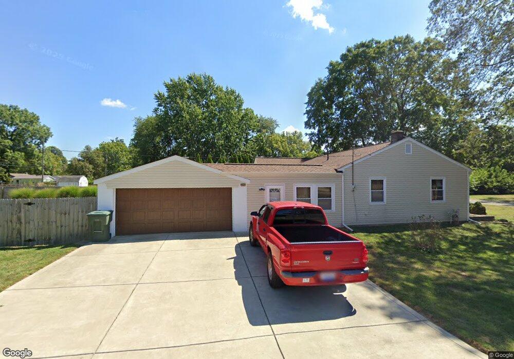
656 Stockbridge Rd Columbus, OH 43207
Obetz-Lockbourne NeighborhoodEstimated Value: $190,000 - $214,000
2
Beds
1
Bath
1,188
Sq Ft
$170/Sq Ft
Est. Value
About This Home
This home is located at 656 Stockbridge Rd, Columbus, OH 43207 and is currently estimated at $202,146, approximately $170 per square foot. 656 Stockbridge Rd is a home located in Franklin County with nearby schools including Parsons Elementary School, Buckeye Middle School, and Marion-Franklin High School.
Ownership History
Date
Name
Owned For
Owner Type
Purchase Details
Closed on
Aug 16, 2021
Sold by
Kessler Michael D
Bought by
Kessler Michael D and Michael D Kessler Revocable Li
Current Estimated Value
Purchase Details
Closed on
Sep 18, 1990
Bought by
Kessler Michael D
Purchase Details
Closed on
Jul 21, 1987
Purchase Details
Closed on
May 1, 1983
Create a Home Valuation Report for This Property
The Home Valuation Report is an in-depth analysis detailing your home's value as well as a comparison with similar homes in the area
Home Values in the Area
Average Home Value in this Area
Purchase History
We collect this data history from publicly available records. To have your information removed, we recommend requesting removal directly through your county’s website.
| Date | Buyer | Sale Price | Title Company |
|---|---|---|---|
| Kessler Michael D | -- | None Available | |
| Kessler Michael D | $55,900 | -- | |
| -- | $51,500 | -- | |
| -- | -- | -- |
Source: Public Records
Tax History
| Year | Tax Paid | Tax Assessment Tax Assessment Total Assessment is a certain percentage of the fair market value that is determined by local assessors to be the total taxable value of land and additions on the property. | Land | Improvement |
|---|---|---|---|---|
| 2025 | $2,534 | $66,260 | $22,020 | $44,240 |
| 2024 | $2,534 | $66,260 | $22,020 | $44,240 |
| 2023 | $2,529 | $66,255 | $22,015 | $44,240 |
| 2022 | $1,826 | $35,210 | $18,830 | $16,380 |
| 2021 | $1,375 | $35,210 | $18,830 | $16,380 |
| 2020 | $1,377 | $35,210 | $18,830 | $16,380 |
| 2019 | $1,248 | $29,330 | $16,380 | $12,950 |
| 2018 | $1,158 | $29,330 | $16,380 | $12,950 |
| 2017 | $1,213 | $29,330 | $16,380 | $12,950 |
| 2016 | $1,178 | $26,530 | $5,740 | $20,790 |
| 2015 | $1,069 | $26,530 | $5,740 | $20,790 |
| 2014 | $1,072 | $26,530 | $5,740 | $20,790 |
| 2013 | $571 | $27,930 | $6,055 | $21,875 |
Source: Public Records
Map
Nearby Homes
- 589 Basswood Rd
- 710 Colton Rd
- 691 Colton Rd
- 492 Basswood Rd
- 3286 Hilock Place
- 3251 Hilock Ct
- 0 Williams Rd
- 443 Carolann Ave
- 435 Carolann Ave
- 1061 Williams Rd
- 1127 Rumsey Rd
- 3637 S Champion Ave
- 3725 S Ohio Ave
- 562 Ashwood Rd
- 3747 S Ohio Ave
- 3113 Hillgate Rd
- 3757 Amwell Rd W
- 503 Ashwood Rd
- 3724 Abney Rd
- 3785 S Ohio Ave
- 672 Stockbridge Rd
- 642 Stockbridge Rd
- 634 Stockbridge Rd
- 643 Basswood Rd
- 684 Stockbridge Rd
- 657 Basswood Rd
- 657 Stockbridge Rd
- 626 Stockbridge Rd
- 617 Basswood Rd
- 671 Stockbridge Rd
- 671 Basswood Rd
- 635 Stockbridge Rd
- 614 Stockbridge Rd
- 696 Stockbridge Rd
- 679 Stockbridge Rd
- 603 Basswood Rd
- 608 Stockbridge Rd
- 615 Stockbridge Rd
- 679 Basswood Rd
- 593 Basswood Rd
Your Personal Tour Guide
Ask me questions while you tour the home.