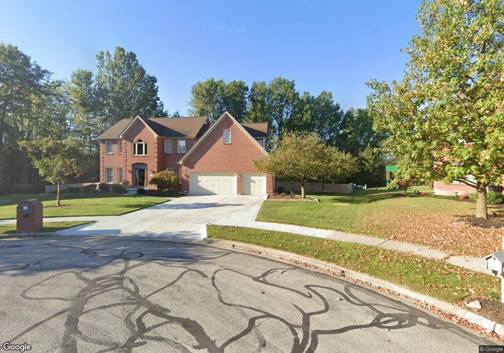
657 Sandpiper Ct Westerville, OH 43082
Estimated Value: $616,499 - $687,000
4
Beds
3
Baths
2,992
Sq Ft
$212/Sq Ft
Est. Value
About This Home
This home is located at 657 Sandpiper Ct, Westerville, OH 43082 and is currently estimated at $635,375, approximately $212 per square foot. 657 Sandpiper Ct is a home located in Delaware County with nearby schools including Robert Frost Elementary School, Heritage Middle School, and Westerville-North High School.
Ownership History
Date
Name
Owned For
Owner Type
Purchase Details
Closed on
Feb 7, 2019
Sold by
Ringer Julie B
Bought by
Ringer Durone D
Current Estimated Value
Purchase Details
Closed on
Mar 9, 1998
Sold by
Silvestri Custom Homes I
Bought by
Ringer Julie B and Ringer Durone D
Home Financials for this Owner
Home Financials are based on the most recent Mortgage that was taken out on this home.
Original Mortgage
$150,000
Outstanding Balance
$27,586
Interest Rate
7.08%
Mortgage Type
New Conventional
Estimated Equity
$607,789
Create a Home Valuation Report for This Property
The Home Valuation Report is an in-depth analysis detailing your home's value as well as a comparison with similar homes in the area
Home Values in the Area
Average Home Value in this Area
Purchase History
We collect this data history from publicly available records. To have your information removed, we recommend requesting removal directly through your county’s website.
| Date | Buyer | Sale Price | Title Company |
|---|---|---|---|
| Ringer Durone D | -- | None Available | |
| Ringer Julie B | $344,240 | -- |
Source: Public Records
Mortgage History
We collect this data history from publicly available records. To have your information removed, we recommend requesting removal directly through your county’s website.
| Date | Status | Borrower | Loan Amount |
|---|---|---|---|
| Open | Ringer Julie B | $150,000 |
Source: Public Records
Tax History
| Year | Tax Paid | Tax Assessment Tax Assessment Total Assessment is a certain percentage of the fair market value that is determined by local assessors to be the total taxable value of land and additions on the property. | Land | Improvement |
|---|---|---|---|---|
| 2024 | $8,598 | $168,770 | $39,550 | $129,220 |
| 2023 | $8,500 | $168,770 | $39,550 | $129,220 |
| 2022 | $8,918 | $137,000 | $33,290 | $103,710 |
| 2021 | $8,995 | $137,000 | $33,290 | $103,710 |
| 2020 | $9,055 | $137,000 | $33,290 | $103,710 |
| 2019 | $7,921 | $123,240 | $28,950 | $94,290 |
| 2018 | $7,788 | $123,240 | $28,950 | $94,290 |
| 2017 | $7,825 | $120,370 | $27,020 | $93,350 |
| 2016 | $8,283 | $120,370 | $27,020 | $93,350 |
| 2015 | $7,924 | $120,370 | $27,020 | $93,350 |
| 2014 | $8,003 | $120,370 | $27,020 | $93,350 |
| 2013 | $8,006 | $120,370 | $27,020 | $93,350 |
Source: Public Records
Map
Nearby Homes
- 980 Landings Loop N
- 6945 Tussic Street Rd
- 1135 Tidewater Ct
- 7568 Park Bend Ct
- 1128 Tidewater Ct
- 6693 Spring Run Dr
- 1067 Weatherwood Ct
- 622 Penbrook St
- 422 Ashford Dr
- 6685 Tussic Street Rd
- 8133 Dunaway Ln
- 6584 Wild Rose Ln
- 498 Olde Mill Dr
- 487 Mill Wind Dr
- 746 Woodbend Dr
- 7026 Sunbury Rd
- 579 Olde Mill Dr
- 766 Kingsmead Rd Unit 27766
- 278 Barrington Dr
- 263 Barrington Dr
Your Personal Tour Guide
Ask me questions while you tour the home.