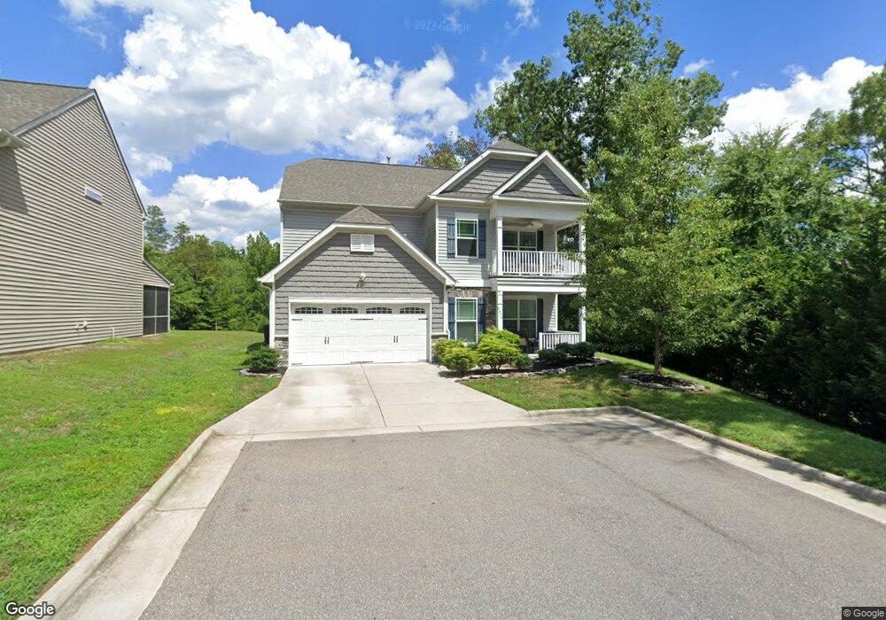
6674 Maize Dr High Point, NC 27265
Estimated Value: $381,592 - $513,000
5
Beds
4
Baths
3,503
Sq Ft
$126/Sq Ft
Est. Value
About This Home
This home is located at 6674 Maize Dr, High Point, NC 27265 and is currently estimated at $442,648, approximately $126 per square foot. 6674 Maize Dr is a home with nearby schools including Wallburg Elementary School, Ledford Middle School, and Ledford High School.
Ownership History
Date
Name
Owned For
Owner Type
Purchase Details
Closed on
Dec 23, 2013
Sold by
Eastwood Construction Llc
Bought by
Lanning Kiley Chet and Lanning Tobbie B
Current Estimated Value
Home Financials for this Owner
Home Financials are based on the most recent Mortgage that was taken out on this home.
Original Mortgage
$223,131
Outstanding Balance
$167,887
Interest Rate
4.38%
Mortgage Type
New Conventional
Estimated Equity
$274,761
Purchase Details
Closed on
Jul 24, 2013
Sold by
Shugart Development Llc
Bought by
Eastwood Construction Llc
Create a Home Valuation Report for This Property
The Home Valuation Report is an in-depth analysis detailing your home's value as well as a comparison with similar homes in the area
Purchase History
| Date | Buyer | Sale Price | Title Company |
|---|---|---|---|
| Lanning Kiley Chet | $235,000 | None Available | |
| Eastwood Construction Llc | $34,000 | None Available |
Source: Public Records
Mortgage History
| Date | Status | Borrower | Loan Amount |
|---|---|---|---|
| Open | Lanning Kiley Chet | $223,131 |
Source: Public Records
Tax History
| Year | Tax Paid | Tax Assessment Tax Assessment Total Assessment is a certain percentage of the fair market value that is determined by local assessors to be the total taxable value of land and additions on the property. | Land | Improvement |
|---|---|---|---|---|
| 2025 | $3,473 | $296,930 | $0 | $0 |
| 2024 | $3,473 | $296,930 | $0 | $0 |
| 2023 | $3,385 | $296,930 | $0 | $0 |
| 2022 | $3,385 | $296,930 | $0 | $0 |
| 2021 | $3,473 | $296,930 | $0 | $0 |
| 2020 | $2,790 | $238,510 | $0 | $0 |
| 2019 | $448 | $238,510 | $0 | $0 |
| 2018 | $2,819 | $237,380 | $0 | $0 |
| 2017 | $2,819 | $237,380 | $0 | $0 |
| 2016 | $2,819 | $237,380 | $0 | $0 |
| 2015 | $2,825 | $237,380 | $0 | $0 |
| 2014 | $2,919 | $242,470 | $0 | $0 |
Source: Public Records
Map
Nearby Homes
- 693 Ansley Way
- 4020 Centerpiece Ct
- 818 Falls Grove Trail
- 397 Curry Rd
- 424 Sandybrooke Dr
- 872 Falls Grove Trail
- 892 Falls Grove Trail
- 6148 Tory Ct
- 6121 Hedgecock Cir Unit 2C
- 3419 Willowcrest St
- 6112 Hedgecock Cir
- 111 Seward Ave
- 220 Hedgecock Rd
- 1513 Birkdale Ct
- 1366 Bayswater Dr
- 110 Hedgecock Rd
- 1329 Bayswater Dr
- 118 Asbill Ave
- 3300 N Main St
- 5430 Forester Dr Unit 3D
- 6678 Maize Dr
- 6682 Maize Dr
- 6686 Maize Dr
- 6702 Planters Dr
- 6704 Planters Dr
- 6691 Maize Dr
- 6708 Planters Dr
- 275 Richview Cir
- 6703 Maize Dr
- 6710 Planters Dr
- 319 Cedarwood Trail
- 6707 Maize Dr
- 6703 Planters Dr
- 6712 Planters Dr
- 6707 Planters Dr
- 6711 Maize Dr
- 6711 Planters Dr
- 313 Cedarwood Trail
- 6715 Maize Dr
- 6720 Maize Dr
Your Personal Tour Guide
Ask me questions while you tour the home.