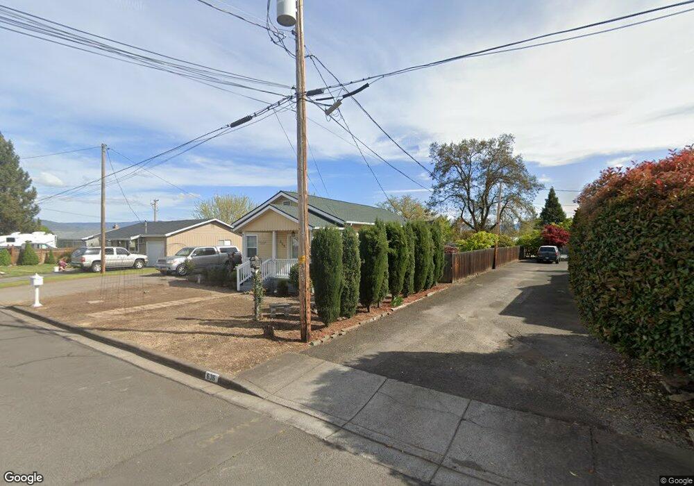
668 Cedar St Central Point, OR 97502
Estimated Value: $258,000 - $302,000
2
Beds
1
Bath
1,000
Sq Ft
$281/Sq Ft
Est. Value
About This Home
This home is located at 668 Cedar St, Central Point, OR 97502 and is currently estimated at $280,572, approximately $280 per square foot. 668 Cedar St is a home located in Jackson County with nearby schools including Central Point Elementary School, Scenic Middle School, and Crater High School.
Ownership History
Date
Name
Owned For
Owner Type
Purchase Details
Closed on
Mar 7, 2012
Sold by
Nielsen Christina
Bought by
Nielsen Christina and Christina Nielsen Living Trust
Current Estimated Value
Purchase Details
Closed on
Aug 4, 2009
Sold by
Mullins Rebecca A and Streibig Michael
Bought by
Nielsen Christina
Purchase Details
Closed on
Aug 30, 2004
Sold by
Pla Alvaro and Mullins Rebecca A
Bought by
Mullins Rebecca A and Streibig Michael
Home Financials for this Owner
Home Financials are based on the most recent Mortgage that was taken out on this home.
Original Mortgage
$114,492
Interest Rate
5.92%
Mortgage Type
FHA
Purchase Details
Closed on
Sep 28, 2000
Sold by
Poulos Joanne
Bought by
Pla Alvaro and Mullins Rebecca A
Home Financials for this Owner
Home Financials are based on the most recent Mortgage that was taken out on this home.
Original Mortgage
$96,402
Interest Rate
7.98%
Mortgage Type
FHA
Create a Home Valuation Report for This Property
The Home Valuation Report is an in-depth analysis detailing your home's value as well as a comparison with similar homes in the area
Purchase History
We collect this data history from publicly available records. To have your information removed, we recommend requesting removal directly through your county’s website.
| Date | Buyer | Sale Price | Title Company |
|---|---|---|---|
| Nielsen Christina | -- | None Available | |
| Nielsen Christina | $140,000 | Ticor Title Company Of Or | |
| Mullins Rebecca A | $10,600 | Ticor Title | |
| Pla Alvaro | $96,600 | Crater Title Insurance |
Source: Public Records
Mortgage History
We collect this data history from publicly available records. To have your information removed, we recommend requesting removal directly through your county’s website.
| Date | Status | Borrower | Loan Amount |
|---|---|---|---|
| Previous Owner | Mullins Rebecca A | $114,492 | |
| Previous Owner | Pla Alvaro | $96,402 |
Source: Public Records
Tax History
| Year | Tax Paid | Tax Assessment Tax Assessment Total Assessment is a certain percentage of the fair market value that is determined by local assessors to be the total taxable value of land and additions on the property. | Land | Improvement |
|---|---|---|---|---|
| 2026 | $1,923 | $116,200 | -- | -- |
| 2025 | $1,876 | $112,820 | $63,530 | $49,290 |
| 2024 | $1,876 | $109,540 | $61,690 | $47,850 |
| 2023 | $1,815 | $106,350 | $59,890 | $46,460 |
| 2022 | $1,773 | $106,350 | $59,890 | $46,460 |
| 2021 | $1,723 | $103,260 | $58,150 | $45,110 |
| 2020 | $1,672 | $100,260 | $56,460 | $43,800 |
| 2019 | $1,631 | $94,510 | $53,230 | $41,280 |
| 2018 | $1,581 | $91,760 | $51,680 | $40,080 |
| 2017 | $1,542 | $91,760 | $51,680 | $40,080 |
| 2016 | $1,497 | $86,500 | $48,720 | $37,780 |
| 2015 | $1,378 | $85,180 | $50,280 | $34,900 |
| 2014 | $1,317 | $80,500 | $46,550 | $33,950 |
Source: Public Records
Map
Nearby Homes
- 450 Freeman Rd
- 555 Freeman Rd Unit 242
- 555 Freeman Rd Unit 257
- 555 Freeman Rd Unit 127
- 647 Shadow Way
- 301 Freeman Rd Unit 30
- 301 Freeman Rd Unit 92
- 301 Freeman Rd Unit 91
- 301 Freeman Rd Unit 70
- 301 Freeman Rd Unit 90
- 604 Hemlock Ave
- 783 Columbine Way
- 230 Peninger Rd
- 512 Village Dr Unit B5
- 1175 Lindsey Ct
- 786 Pittview Ave
- 547 Laurel St
- 566 Village Dr Unit F23
- 3364 Bursell Rd
- 1600 E Pine St
Your Personal Tour Guide
Ask me questions while you tour the home.